Archive

Tag Archives: big sur

We were camping at Huntington Beach in South Carolina, and I woke up before dawn and walked down to the ocean. The sky was beginning to brighten to the east and I watched for the coming sunrise. 

When the sun broke the horizon, its motion was noticeable and I watched it slowly lift from the water. But then, something happened: The sun stopped dead in its tracks and my frame of reference shifted involuntarily and instead of the sun moving up, the earth I was standing on jerked forward, as if I were coming over the top of a ferris wheel and I nearly lost my balance. It seemed the ground was moving away from under my feet, toward the immobile sun. 

At the same time, seawaves reflected the bright copper sheen and the shadowed portions of the water formed a network of glossy black, making the entire landscape before me into a shimmering enameled lattice and more, it seemed not so much to reflect the sun, but rather to be glowing from within. 

The magic lasted only a few moments and the earth stood still again and the sun began climbing once more. I felt that I had been given a chance to see how things really were — a stationary sun and a rotating earth — and the whole, with its copper and black waves, was unutterably beautiful.

Such visions are epiphanies. 

Of course, “Epiphany” means different things. In the Roman church, it is the name for the visitation of the wise men; in the Orthodox churches, it marks the baptism of Jesus and the descent of the dove; according to some early Church fathers, it marks the miracle at the wedding feast at Cana; and for Syriac Christians, it celebrates the rising light of dawn, as expressed in Luke 1:78. In all these versions, it refers to the recognition of divinity as it shines forth. 

But I take the word for its otherwise secular meanings. It is a sudden recognition of reality, or the momentary transformation of the ordinary into something strange, or the psychological state of overlaying the personal in registration with the objective world, the way you might orient a map to match the landscape in front of you. Then the two meld into a single thing. In any version, you experience a moment out of time. 

It is the word James Joyce used when referring to such experiences, usually something quite ordinary, but seen in a new, illuminating way. A theophany with no theos

In his early novel, Stephen Hero, he defined these epiphanies as “a sudden spiritual manifestation, whether in the vulgarity of speech or of gesture or in a memorable phase of the mind itself.” And he “believed that it was for the man of letters to record these epiphanies with extreme care, seeing that they themselves are the most delicate and evanescent of moments.” 

In an early manuscript, Joyce collected 22 pages of these moments he found in his own life, and used many of them later in his finished works. At one point, there were at least 71 epiphanies written down in Joyce’s own handwriting. 

Later in his career, the term grew in meaning and significance, and tends to mean moments of behavior observed or experienced that seem to metaphorically summarize some insight or contain “meaning” in some way or other. 

In ordinary usage, “meaning” is a term of translation: “This means that,” but it has another purpose: significance. An experiences doesn’t have to “mean” something that we can express in paraphrase, or take as a lesson we have learned, but can have meaning, unexplainable except in terms of itself, as when a dream feels meaningful even if you don’t know why. 

I believe we all have such moments. They tend to stick with us. I know I have had them throughout my life. The first one I can remember was at the age of four or five and driving with my family along the Palisades at night, looking across the Hudson River at the constellation of lights in the darkened Manhattan buildings. It was my first remembered experience of something I would call beauty. I couldn’t wait for the next time we visited my grandparents so I could see those lights again. 

Often we function as actors in a stage set, with the world as backdrop. Our focus is on the particular action or conversation, with the set merely happenstance; it could easily be some other set. But the epiphany is when you step back and see actor, set, words, as a single unit, all of a piece. We can live our lives barely noticing the world we walk through, except as it helps or hinders us — it is functional. But that moment comes when the boundary between us and the rest of it all evaporates and we sense ourselves as part of a whole. That instant is the epiphany and for it, time stops, even as the clock keeps moving. It is an uncanny feeling.

It feels as if you are taken out of the real world for a moment, but actually, you are dropped into it. The illusion of separateness is dispelled and you become face to face with something bigger. 

When I was about 10, my younger brother, Craig, and I thought to follow the brook that ran through our property in New Jersey, through the woods behind the house, to see where it went. It ended as it fed into the Hackensack River. We then followed the river to the Oradell Reservoir and followed the railroad tracks. We were crossing a little bridge when a train arrived and we ducked under the bridge, sitting on the concrete abutment  not more than a couple of feet from the screaming wheels of the train as it passed over. Time may have stopped, but the train didn’t. It was thrilling. It was untameably real. 

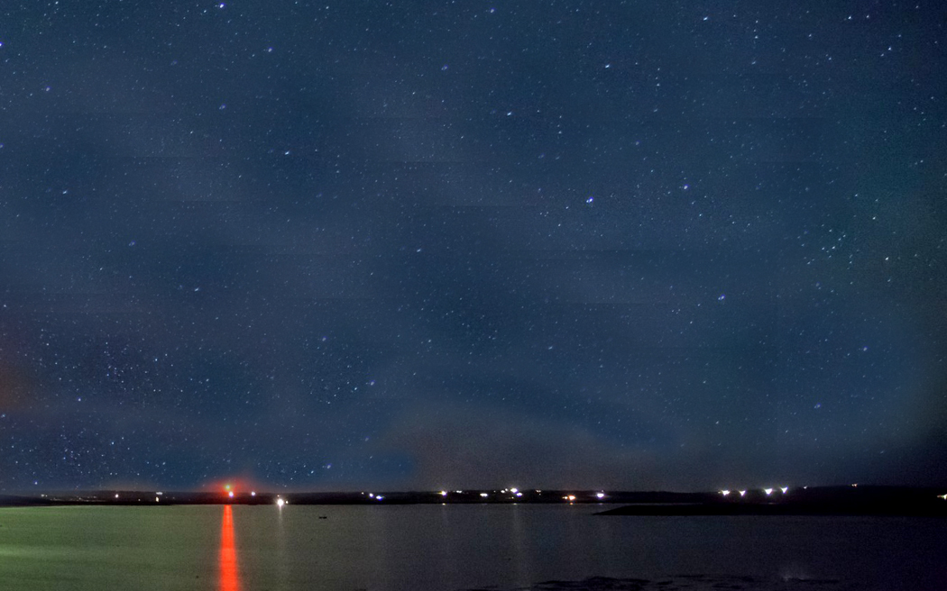
In high school, I spent one summer vacation in Europe, crossing over the Atlantic on a steamship. After days of faceless unchanging ocean horizon, one  night came when on deck I looked out and saw pinpricks of light in the darkness, maybe 8 or ten miles away. It was the Orkney Islands and I was dumbstruck at their remoteness. They were ghostly lights strung out along the horizon in a seemingly infinite blackness. They seemed unmoored to this now. 

There is often sense of the uncanny, of something we don’t quite see, but feel it is there. 

On night, I was driving up the Big Sur, between San Luis Obispo and Monterey. With the sun finally below the horizon, it was completely black, but with grades of black showing in front of me. The blackest black is rock, rising in cliffs to the right side of the road. The glossiest black was the ocean on the left below. As I whipped along the road with my up-beams gleaming back at me from the reflectors on the road stripe, I could occasionally see a flash of light in the corner of my eye. When I looked, there is nothing, but when I turned back to the road, it flashed again. But there seemed to be something riding beside my car. I called it the “God of the Nighttime Highway.” 

It turned out to be my own running lights reflecting off the guard rail at the edge of the road. But for 10 minutes or so, until I figured it out, the experience was eerie and I almost believed in a spirit world that I don’t believe in. 

I imagine it must be episodes like this that gave rise to the myths and folklores of the ancients. The experience feels so real, it must be real. 

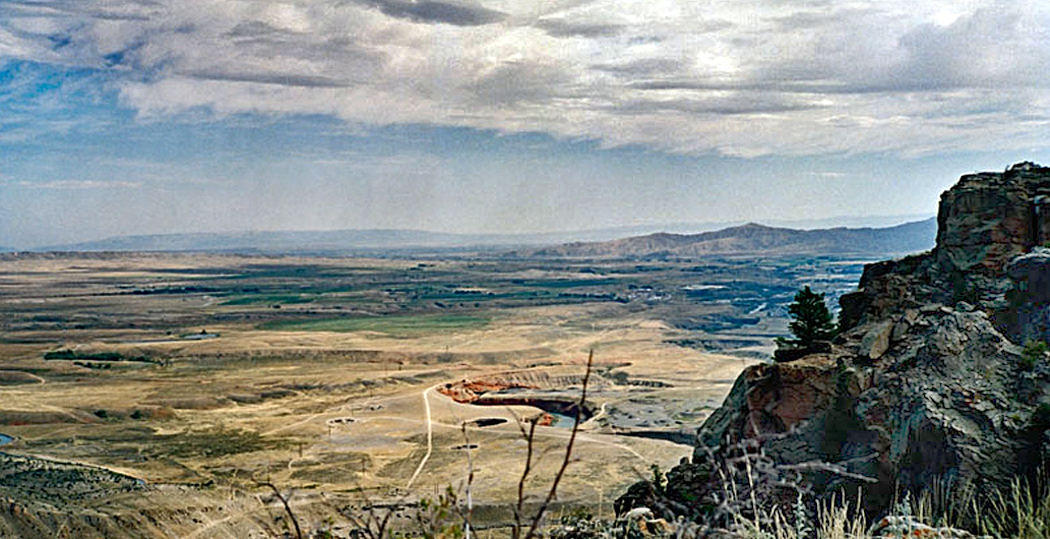
And these epiphanies are not especially rare. I’ve had many in my life. My wife and I had left Yellowstone National Park early on a gray, rainy day, driving eastward on the North Fork Highway through Wyoming’s Shoshone Canyon. At the canyon’s mouth the land broadened out and dipped down into vast plains with the Buffalo Bill Reservoir in the distance. We had just turned on the radio and the skies suddenly parted and the scene before us was drenched in sunlight just as the radio began pouring out the early morning sign-on music of “America the Beautiful,” and the Mormon Tabernacle Choir sang, “Oh beautiful for spacious skies and amber waves of grain…” And there it was, before us, just as in the song, and we had to laugh, but also we had to recognize the emotional power of what we were seeing. 

Once, camping at the Outer Banks with my friend Sandro, we walked along the beach at Hatteras Point at night, carrying a Coleman lantern. The air was so humid that it was on the edge of becoming fog. And the light we carried threw our shadows up into the sky, among the stars, and we could see we were giants. 

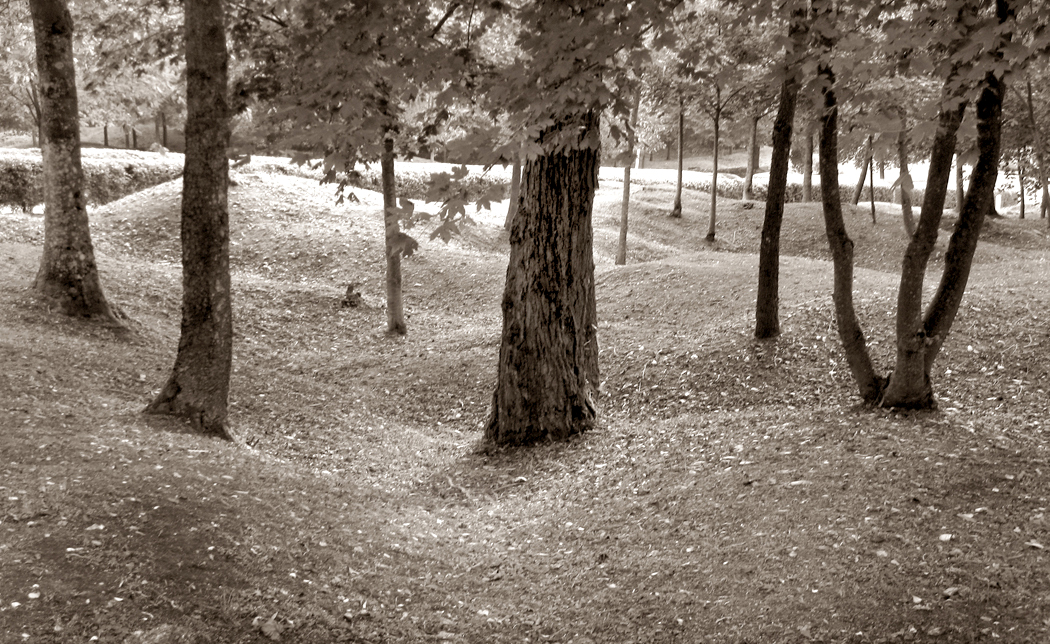
Or, visiting Verdun in France, my wife and I drove through the old World War I battlefields that had been blasted into moonscape by artillery fire, but now had grown back into woodlands. But there, between the tree trunks, the shell craters were still there, pock-marking the ground nearly a hundred years later. 

I’ve had that strange recognition many times when visiting old battle sites — as if the past is always present. I’ve had it at Antietam, at the Little Bighorn, at Shiloh, at the Normandy beaches, at Wounded Knee, at Appomattox. The epiphany that breaks through isn’t just history as you read it in books, but rather the persistence of events: that what once happened is still happening; wave ripples running out through time. 

I once spent the night alone on the North Rim of the Grand Canyon in Arizona. My campsite was a good 30 miles from any other human being and the sky was darker than any I had seen before or since and the stars were spilled like beach sand across the expanse, with the Milky Way splitting the dome in two. About 3 in the morning, I woke up, left the tent and sat on the hood of my car, staring up at the infinity. I stared for maybe 20 minutes or a half hour, and a kind of hypnosis took over and I no longer felt like I was on my back staring up, but rather as if I were at the forward point of a planet racing through infinite space toward those stars. The planet was at my back, and I could almost feel the wind on my face as this planetary vehicle was racing forward toward the lights. 

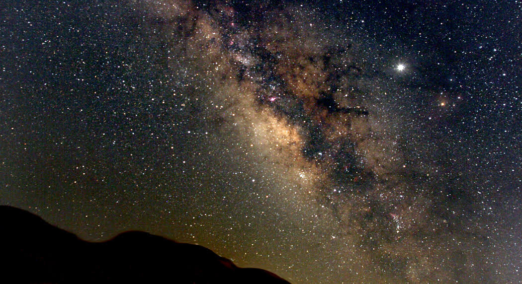
And, of course, this is exactly what was happening. The ordinary sense of terra firma under a wide sky is the illusion. The recognition of a giant ball of earth and water raging through an infinite void is the reality. Sometimes we see it that way. 

And that is the epiphany. 

pacific coast highway

The Pacific Coast Highway travels up the western edge of the North American continent like the vein down the back of a shrimp. 

It has claim to being the single most scenic road in America, passing between the mountains and the sea for 1,500 miles from Southern California to Puget Sound in Washington. 

There may be shorter sections of other roads through the Rocky Mountains or the Appalachians that are equally stunning, but nothing approaches the Pacific Coast Highway for glory over so long a haul. 

If you pick it up in San Francisco, you cross the Golden Gate Bridge and north of the city, you take the cutoff for California Highway 1, leaving behind U.S. 101, and head for the hills. The road to the coast is so curvy and filled with switchbacks, you swear to give up driving altogether. But it finally breaks out onto the sea, and the ride is one of the best in the world.PCH north of SF

The northern half of the Pacific Coast Highway is notable for its quiet emptiness, but that doesn’t mean there is nothing to do. 

Among the attractions you will pass on the Pacific Coast Highway driving from San Francisco to Olympia, Wash.: 

Marin Headlands National Recreation Area — Within sight of the Golden Gate Bridge, the headlands rise above the frequent fog and provide hiking, beaches, history and a Nike missile silo. golden gate bridge in fog

Muir Woods National Monument — One of the great groves of redwood trees, just a short hop from the city and great place for a quiet walk in the woods. 

Bolinas — The small town at the south end of Point Reyes doesn’t encourage tourism. Its citizens have been known to take down the road sign out on the highway to mislead travelers. But it so beautiful a town you can understand why they want to keep it to themselves. 

Point Reyes National Seashore — California 1 rides literally atop the San Andreas fault along the eastern edge of Point Reyes. On the other side, a renegade tectonic plate slowly has floated from Southern California to its current location north of San Francisco. Its hills, beaches and farms eventually will move north to Alaska, but give it a few million years to do so.

We’ll take the road further north, but let’s now consider the southern part of the route. We’ve already covered the glory of the Big Sur, but not all of the southern half of the road is quite so sublime. 

It is, of course, not a single highway, but a confusion of roads, for the PCH, as it is known in LA, is not an official name but a popular one, and it covers several U.S. and state route numbers. 

It is best known, for instance, as the beach road in Santa Monica. You will hear natives say they are going to take the PCH to Point Dume or Leo Carrillo State Beach, but the map of the area shows that the road they drive actually is called Palisades Beach Road. 

What is more, when it was cut through the bluff bottom in 1929, it was called the Roosevelt Highway. That is still its secondary name. 

It is also California Route 1. Through most of the state, the PCH follows California 1 and U.S. 101, hugging the coast and its scenery. 

The PCH is born haltingly and in patches south of Los Angeles. 

If you drive north from San Diego, you will be able to skirt the ocean through the city suburbs. California S21 goes through Del Mar and Cardiff-by-the-Sea, but north of Oceanside, you have no choice: You have to get on the interstate. Interstate 5 goes through Camp Pendleton and San Clemente to the actual origin of California 1 near San Juan Capistrano. 

As it travels north through Orange County and Los Angeles, California 1 is just a city street, blocked with stoplights and suffocated with traffic. It isn’t until Santa Monica that it develops its character. The spiritual beginning of the highway is where Interstate 10 ends and dumps out on the PCH under the muddy slumping palisades past the Santa Monica Pier. PCH begins at santa monica

This is the beach California is famous for — surfers and frozen yogurt shops, lifeguard stands and parking lots crammed to the gills with shiny Hondas and Toyotas. The land of swelling bikinis and glistening sunglasses. 

On summer weekends, the traffic is bumper to bumper through Topanga Beach and Malibu. It doesn’t let up — and then only a little — till past Point Dume. But the wait is worth it as the natural world reasserts itself at El Matador, El Pescador and Leo Carrillo state beaches. PCH at_Gladstones Malibu

And if you are lucky enough to be there at midweek in midwinter, you can have the beach all to yourself. Los Angeles is just a bad urban memory. 

For the next 100 miles, the road alternates between beach and city, passing Oxnard, Santa Barbara and San Luis Obispo on one hand and Point Magu, Refugio Beach and Pismo Beach on the other. The road takes a long inland detour around Vandenberg Air Force Base, through Lompoc, beloved foil for W.C. Fields, and although the ocean is hidden, the grassy golden hills of California make a fitting substitute. 

It is north of Morro Bay, however, that the PCH earns its reputation. It would be hard to find a more stunning stretch of coast road anywhere. 

California 1 rides a shelf above the sea cliffs with the ocean on the west and the foothills of the Santa Lucia Mountains to the east. At times, the mountains crowd on the highway; elsewhere, the broad grassy plain widens out, pushing the mountains back. Farmhouses and pasture fence off the flats and some of the country’s best campsites are just beside the road. 

William Randolph Hearst’s castle, San Simeon, is the biggest single attraction in the area. The original yellow journalist and the newspaper publisher who brought us the Spanish-American War spent more than a quarter of a century building the mansion, turning it into a grandiose monument of risible bad taste. 

So much for the comic relief: The grand climax of the entire West Coast rises out of the water north of San Simeon. Big Sur, it is called, and it is the very model of the rocks and sea fighting over territory. Bixby Creek Bridge Big Sur

The highway through the area wasn’t opened until 1937. Men died cutting the road from the mountains. It corkscrews in and out of coves and headlands, up and down, with precipices to one side and breakers to the other. 

Writer Henry Miller lived in the area in a little shack on Anderson Creek for years. 

”Often when the clouds pile up in the north and the sea is churned with whitecaps, I say to myself: ‘This is the California that men dreamed of years ago, this is the Pacific that Balboa looked out on from the Peak of Darien, this is the face of the Earth as the creator intended it to look.’ ” 

Miller also said, ”It was here at Big Sur that I first learned to say amen!”  

Everything beyond the Big Sur is anticlimactic: The land slowly uncurls and flattens and the real estate becomes populated. Carmel-by-the-Sea is a town of tourists and the slumming wealthy. Coffee shops replace redwoods and couture replaces granite. 

Just outside of town, there is Point Lobos State Reserve, a jutting peninsula filled with sea-weathered rock and Monterey cypress. 

And in the town of Monterey, the aquarium is a perennial favorite. 

But the landscape seems hopelessly mercantile after the sublimity of Sur. Monterey Bay is one vast, flat, muddy estuary given over to the growing of garlic and artichokes. 

North of Santa Cruz, nature reasserts herself, though less majestically. At Point Año Nuevo, there is a state reserve where elephant seals breed each winter. Access is by ticket only, and reservations are a necessity. Pigeon Point lighthouse PCH

A few miles along the road, Pigeon Point Lighthouse is the site of a hostel run by American Youth Hostels with a hot tub perched on a rocky cliff. 

The landscape is green and wet, with creeks gathering from the mountain runoff and pouring into the ocean in sandy deltas lined with beach. There is little traffic most of the year, despite the proximity of San Jose, less than 10 miles away but shielded from the coast by impassable mountains. PCH Pacifica headland

But the closer you get to San Francisco, the more development you find. North of Half Moon Bay, there is only one more brief run of wildness, as the road has to bend around San Pedro Mountain. At the place called Devil’s Slide, where the road cuts through a very unstable portion of the mountain, the road often has been closed by landslide. It is now bypassed by the Tom Lantos Tunnels, which are more efficient, but less adventurous. 

The southern half of the Pacific Coast Highway alternates between the most asphalt-choked cities and the most untamed nature, culminating in the great crescendo of the Big Sur. 

It can be seen as a kind of symphony, building to a grand outburst of brass and timpani, then quieting down to a final city cadence. From Los Angeles to San Francisco — something like 500 miles by this circuitous route — you can forget the planet is filled to the breaking point with humanity. You can reacquaint yourself with the elemental forces of rock, water and air and recharge your batteries. 

But there are some people who say it gets even better. North of San Francisco, there is almost nothing but nature. golden gate bridge

If the southern half is a symphony of alternating moods, the northern half of the PCH is more like the Bach cello suites: solitary, quiet, sublime but reflective. At times, you may feel as if you are the only car on the only road in the hemisphere. 

There are state beaches and parks along the way, and a few towns, like Fort Ross and Albion, but for the most part, this is a road between a green interior and a rocky blue sea: a ribbon of innigkeit. At least until you come back to quasi-civilization at Eureka, and the road (now U.S. 101) heads north into Oregon. 

Along the way, there are punctuations. 

Fort Ross State Historic Park — North of the Russian River, you find explanations for the name: Russian architecture speaks of the days when that nation attempted to colonize the western rim of North America. Sonoma Valley fence

Mendocino — One of the most beautiful of the small towns along the PCH, Mendocino is in grave danger of selling out to tourism. It still is worth visiting, but it will not be long before it goes the way of Ferndale to the north. 

Fort Bragg — Much more blue-collar, and therefore much more real, than its tourist-funded neighbors, the town is home to lumber mills and commercial fishing. In it, you can catch the flavor of what actual living is like on the Northern California coast. Mendocino County, Calif Fort Bragg

Leggett — At this little town, not much more than a point on the map, California 1 rejoins U.S. 101 for the trip through the heart of Redwoodland. It is also the home of the ”original” drive-through tree (there are several others). 

Avenue of the Giants — A 33-mile side road that parallels the main highway from Phillipsville to Jordan Creek, California 254 is an old byway that takes you through the heart of the old tourist redwood areas. There are lots of places to buy clocks made from redwood, and several old-fashioned tourist traps for kids. It is hokey enough to be worth visiting. It is also beautiful. 

Humboldt Redwoods State Park — One of the largest stands of redwood, with 50,000 acres along the Eel River, this is the true heart of redwood country. Camping, hiking and just sucking in the ether makes this one of the best stops along the route. 

Scorched redwood, Humboldt Redwoods State Park

Scorched redwood, Humboldt Redwoods State Park

Ferndale — If you really, really want a place to buy souvenirs and ”old fashioned” candy, the likes of which no old-timer ever saw, Ferndale is the place to do it. Like a chunk of gingerbread Disneyland set down in paradise, it reminds us, if we are ever in danger of forgetting, that America runs on money. 

Eureka — The largest town on the route north of San Francisco, Eureka is another gritty blue-collar town, and a healthy dose of reality after the ersatz huckstering of Ferndale. It is also the home of the Samoa Cookhouse, one of the great eating places in the state, where food is served family style and in huge doses. 

Redwood National Park — Spread out in discontiguous patches through Northern California like spots on a Holstein cow, the park protects about 100,000 acres of redwood. It isn’t the best or most impressive stand of redwoods — I recommend Homboldt for that — it still is worth stopping for, especially for the parts that front the ocean. 

Oregon Dunes National Recreation Area — For 50 miles north of Coos Bay, the oceanfront consists of mountainous sand dunes. At Honeyman State Park, 10 miles south of Florence, a 150-foot dune rises over a reflecting pond. 

Sea Lion Caves — Just north of Florence, the waves have cut a monster cave in the sea cliffs and thousands of stellar sea lions come there each year to breed. It is the only such rookery on the American mainland. It is a much worthier stop than it might sound like: The tourist trap angle is played down and the animals are real and fascinating. 

US101 Near Yachats

US101 Near Yachats

Yachats — This small town is the perfect seaside vacation resort, with all the restaurants and motels, marinas and beaches that implies. Oregonians come here to rent ”cottages” for a week or two in the summer. 

Oregon Coast Aquarium — In Newport, the aquarium is an up-to-date modern facility with wonderful exhibits and a must-stop location along the highway, just under one of Oregon’s great, green bridges, this over Yaquina Bay. 

Tillamook — One of the few places where the highway steps back from the water, Tillamook is the home of a cheese factory with tours and the world’s largest all-wooden building, which is, in fact, a blimp hangar with an airplane museum inside. 

Seaside — Actually, the whole piece of coastline from Rockaway Beach through Cannon Beach to Seaside more closely mimics the New Jersey shore than anyplace else in America. It is a place for frozen yogurt, saltwater taffy and bicycle rentals. 

Fort Clatsop — When the Lewis and Clark expedition finally made it to the Pacific in 1805, they stayed in a tiny wooden fort they built and named Fort Clatsop after the local Indians. The re-creation of this fort is one of the great historic sites and gives you a chance to learn how the 40 men, one woman and a baby spent the miserable winter before heading back to civilization. 

Aberdeen — The Aberdeen, Hoquiam bi-city area is built on the lumber business, or at least it used to be. The factories and docks are still there, although not always busy. This industrial town is also the birthplace of Kurt Cobain and you can visit the high school he attended; a scholarship has been set up in his name, sort of the equivalent of a good citizenship award named for Vidmar Quisling. 

Olympic National Park seashore

Olympic National Park seashore

Hoh River Rain Forest — The western side of the Olympic Peninsula gets nearly 12 feet of rain annually, making its temperate forest of hemlock, cedar and Sitka spruce luxuriant beyond all bounds. Giant ferns catch the humidity and green out the understory and all winter long – the rainy season – drops of water spatter from the leafage. 

Olympic National Park — North of the Quinault Indian Reservation, the highway pokes out to the ocean once more, and the Olympic Coastal Strip, part of the national park, follows the shoreline for 57 miles, making this the longest wilderness coastline in the continental U.S. 

Hurricane Ridge — The northern entrance to Olympic National Park sits just south of Port Angeles and the long climb up to Hurricane Ridge is one of the great alpine drives. You likely will pass mountain goats, elk and tons of yellow marmots, and it is not unlikely you will come across snow all year long. 

Olympia — Home of Olympia beer — called ”Oh-lee” by the locals – and the end of the route. It is the state capital, but, most of all, it’s a good place to have a beer and celebrate the end of the drive.

big sur coast

The sun is dropping into the Pacific, and I’m turning north on the Coast Highway, headed for Big Sur.

The California coast south of Monterey is one of the most glorious in the world. It is a great bumping of hard stone and cold seawater. The headlands jut out into the ocean and the waves erode them back, and at all times you hear either surf or wind, and often cannot tell which.

It is one of those animated places in the world’s geology that reminds you that even if there were no people on it, even if no animals, the Earth would still be alive.

Twilight is early and long in December, and although it has been a clear blue day, there is a ridge of fog out at sea that threatens to come inland and block the last rays of sunlight.

It is about 4 p.m. as I leave Morro Bay and head north. The highway is a four-lane divided road and traffic zips at 70 mph past the small resort towns of Harmony, Cambria and San Simeon.

Then the road becomes narrow and so curvy it seems like an asphalt moth as it flits up to the right and down to the left, not making up its mind where it wants to go.

I have been driving nearly 300 miles since leaving the Mojave Desert in the morning. And I’m feeling a little giddy as I drive the car like an arcade game, following the twisting road, racking up points by passing slower traffic.

The fog bank stays out over the water, but a large, dark patch of cloud lowers over the coastal mountains that rise up out of the water. The Coast Highway hugs the shoulders of those mountains, wrapping into the coves, where streams drop into the sea, and back out around the headlands.

For patches, the road will straighten out as it passes through flat grasslands that make a border between the sea cliffs and the more inland hills, but just as you get used to that, the road climbs up and over a rocky promontory and begins weaving again.

This is not a road for everyone. You have to love driving. I do.

So as the sun goes cold behind the fog, and the light turns a shadowless twilight, I race along like a maniac. big sur

It’s most likely that I’m a bit daffy from long hours behind the wheel, but I can’t help myself. I’m enjoying screeching around the bends, taking the hairpin turns on what feels like two wheels, and passing every slow road-clogger whose backside I come up against.

It is a 90-mile stretch along the Big Sur, that great rocky headland that sticks its face into the sea wind between San Luis Obispo and Monterey. In places, the road is nearly washed away. Only one lane remains and traffic has to take turns going north or south along the remaining pavement.

And with the sun finally below the horizon, there is a strip of bright sky remaining above the fog belt and below the great dark cloud. It is reflected in the sea in a phosphorescent turquoise green that cannot be real.

As I whip along the road with my up-beams gleaming back at me from the reflectors on the road stripe, I can occasionally see a flash of light in the corner of my eye. When I look, there is nothing, but when I turn back to the road, it flashes again.

I almost think it is an angel flying beside my Toyota, keeping me safe; but no, it turns out to be my own running lights reflecting off the guard rail at the edge of the road.

When the last bit of dusk has been drenched in black, there is nothing to see but the reflectors. They dance in my eyeballs. I recognize the symptoms of road hypnosis, but I don’t slow down.

Up the rise, around the tight bend, down over the bridge and up the next rise, all I see is the twin yellow lines of dots flashing at me from the center of the road.

The windshield begins to fog. I wipe it inside with a cloth.

A car comes the other way. I drop to low beam. big sur river inn sign

It is completely black, but there are grades of black showing in front of me. The blackest black is rock, rising to the right side of the road. The lightest black is the ocean below.

I am doing 55 around turns that say ”Curve: 25 mph,” alternately braking and accelerating. It has become a game.

But when I finally recognize my own exhaustion, I pull into a motel on Pheneger Creek and feel how cold the air is. I am almost shaking from tiredness. I cannot wait to sleep.