Archive

Tag Archives: kansas

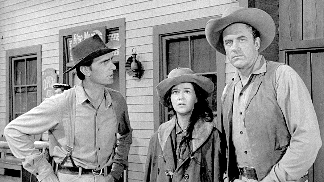
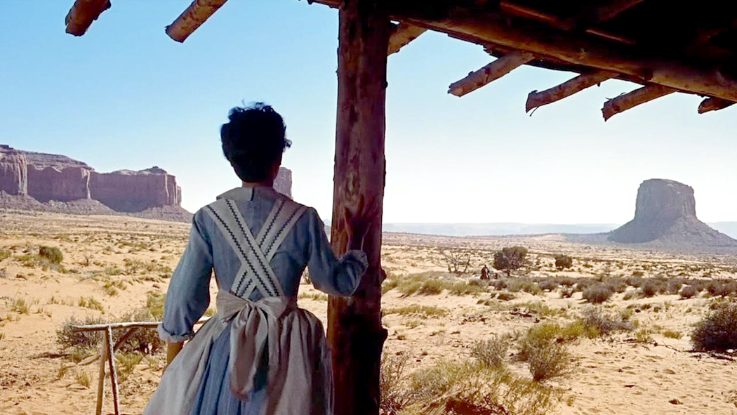
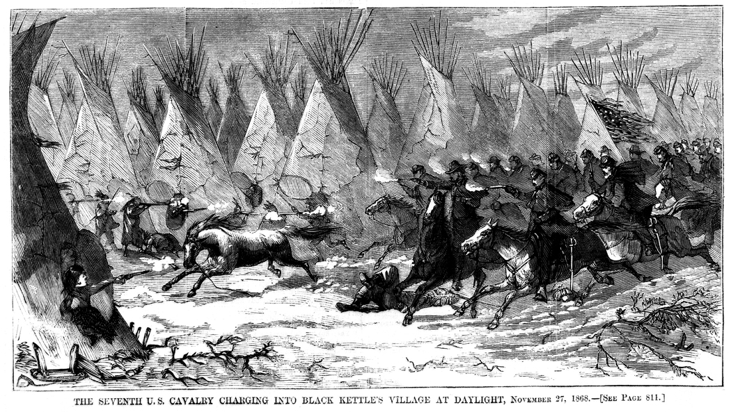
It began when I was watching syndicated reruns of old Gunsmoke episodes and I couldn’t help, as an adult, but wonder, “Where do all these people live?” I mean, there didn’t seem to be any houses in Dodge City. 

Yes, we saw that Marshall Dillon slept on a cot in his office and that Miss Kitty had a room at the back of the saloon, and Doc Adams had an apartment attached to his surgery. And perhaps Sam the bartender had a room upstairs at the Long Branch and perhaps Jonas had a second-floor apartment above his general store. But the town was fully populated with people and the only street we ever see on Gunsmoke is lined with shops and businesses — at least two saloons, the Dodge House hotel and a restaurant where the gang often dined. Where were the houses? 

I know it’s not really important. Westerns are America’s foundational myth, and like myths from the time of Gilgamesh through Ancient Greece and up to Gunsmoke, we don’t ask realism of the stories. They are moral tales, parables, etiologies, and euhemeristic histories. Unnecessary detail just clutters up the telling of the tale. As I said before, no one asks if Hercules had a mortgage. 

But the issue of Dodge City housing interested me nonetheless. 

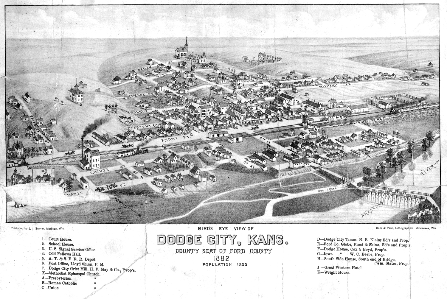
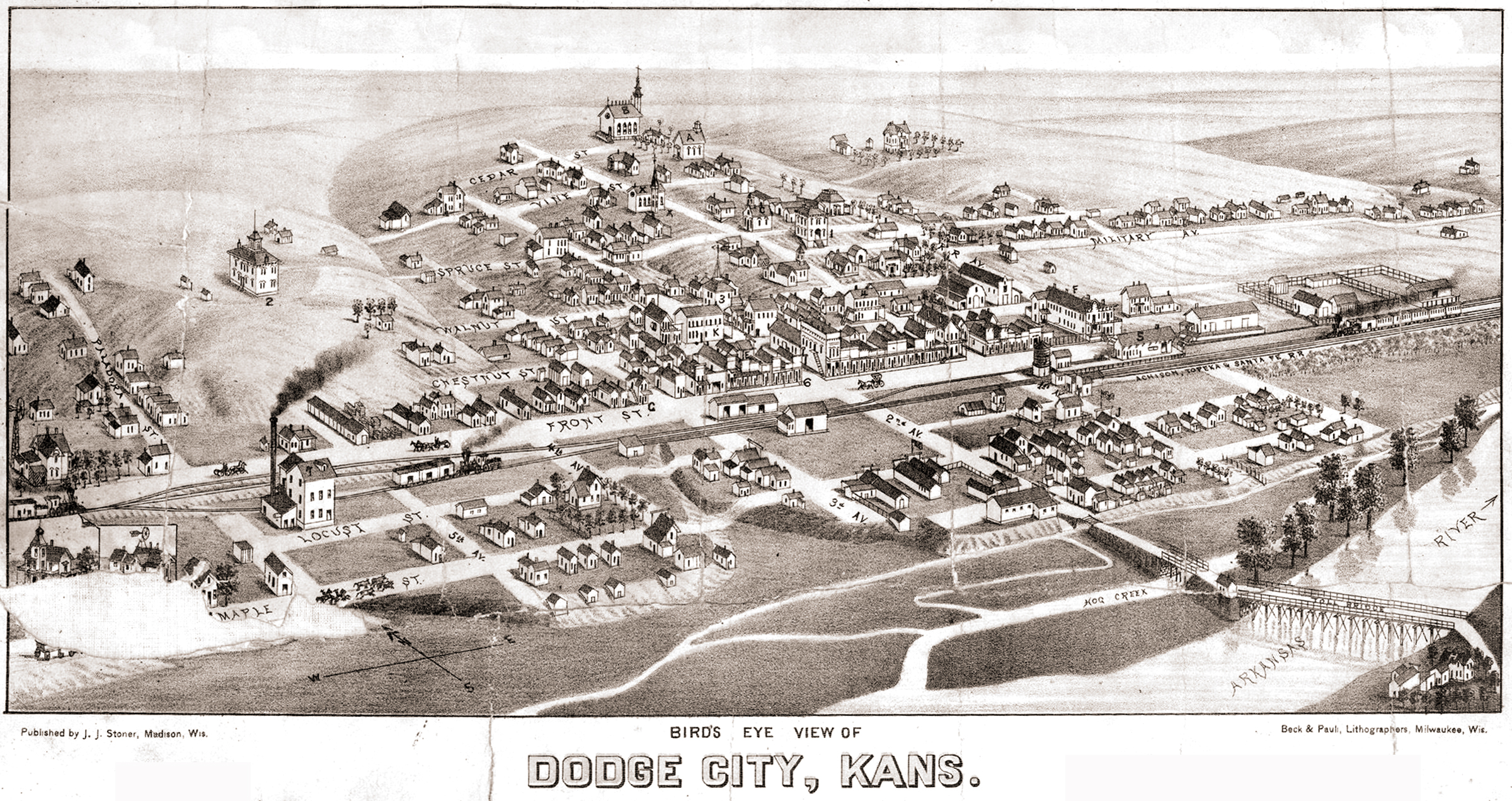
I found an old map of Dodge City from 1882 and there were plenty of houses along the side streets that led off from Front Street, the main road of the town. There were four churches, a courthouse, a school, a grist mill, an Odd Fellows Hall, a railroad depot, a newspaper office and at least four hotels, including the Dodge House, Cox & Boyd, proprietors. 

Admittedly, 1882 is about five or six years later than the fictional Gunsmoke Dodge was supposedly set (according to its creators), but it should tell us something about Western settlements of the era. Yet, except for a few episodes of rowdy trail hands shooting up the place, Gunsmoke rarely mentions either the railroad or the cattle business. Where are the cattle pens? Why does no one ever mention the stink?

Then I discovered a trove of historical photographs from the Gunsmoke era and pored over them for what they might tell me. 

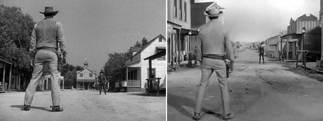
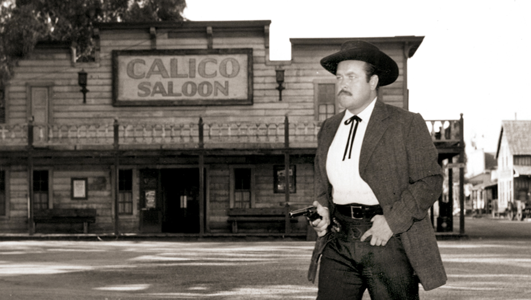
Gunsmoke, first on radio and then on TV for 20 years was intended as an “adult” Western, with more grown-up plots and themes than the standard cowboy movie. And in the early years, largely succeeds, with some quite grim stories about the difficulties of life on the prairie. But even given that, the series relies on many of the Western movie tropes, including its sense of how a Western town is built and functions: one main street lined with storefronts and saloons. 

As I have said, I am not asking a television entertainment to be a documentary, and I am not complaining that Matt Dillon’s town had little to do with the historical Dodge City. But I couldn’t help but want to find out what the reality might have been. 

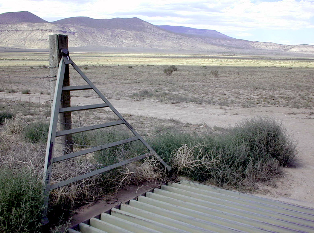
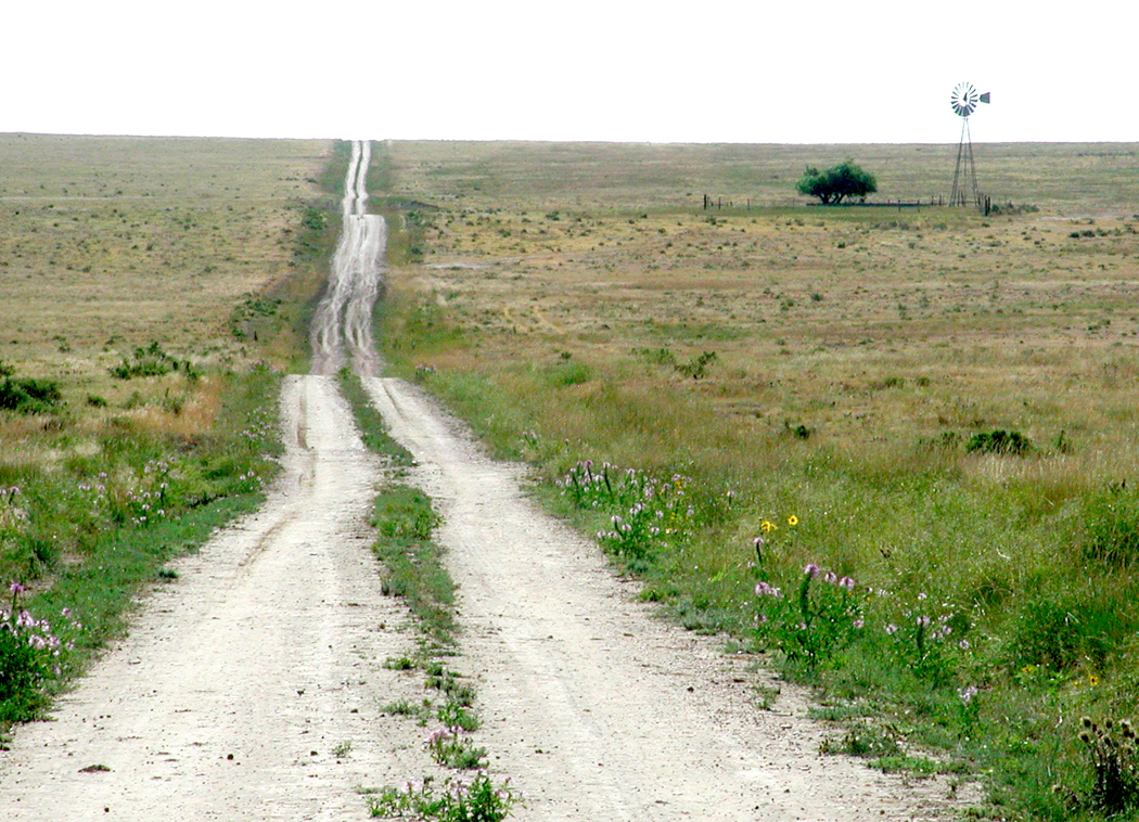
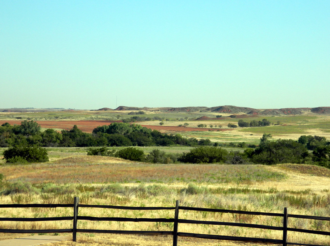
Ruts still visible from the Santa Fe Trail, near Dodge City

A little background: Once, there was a piece of land in the middle of the continent halfway between another piece of land controlled by people speaking English and another piece of land controlled by people speaking Spanish. And the English- and Spanish- speaking peoples wanted to do business together and so wagons of goods moved from one side of America to the other side along familiar routes that eventually became well-worn trails. The one we’re concerned with was called the Santa Fe Trail. 

Of course, the parcel of land between them was not empty, but occupied by native peoples, who sometimes took exception to the Europeans who trespassed over their land, and so, the English-speaking peoples sent out their army to build forts along the trails to protect the merchants and their teamsters, and later to protect the European immigrants who wanted to live in the middle of the continent or travel across it to get to the parts further west. 

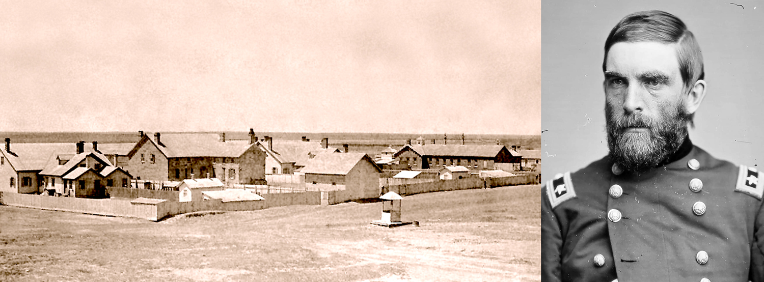
Fort Dodge in 1879 and General Grenville Dodge

And so, on April 10, 1865, a company of soldiers from the Eleventh Cavalry Regiment under orders from General Grenville M. Dodge established a camp on the Arkansas River along the Santa Fe Trail. Lacking building materials, they made dug-outs into the river banks for shelter. Dodge later wrote in his autobiography that the soldiers sarcastically named the place after him because they “were so mad at being sent there .. with so little accommodations that they named the place Camp Dodge.” 


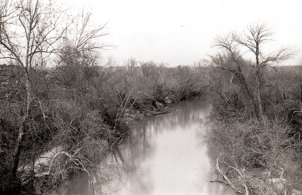
Arkansas River near Fort Dodge

Sidenote No. 1

Researching history can be a nightmare. There are ambiguous and conflicting sources everywhere. Dates are in question, name spellings are helter skelter, tall tales sometimes intrude with frequently told-fictions. First-hand accounts often appear to glorify their authors. I have tried to relate the most dependable version of Dodge City’s history, but there are sometimes smudgy areas. 

For instance, Grenville Dodge isn’t the only Dodge involved, and sometimes one of the others gets credit for the fort’s name. In 1851 a Col. I Dodge established a fort to protect the Santa Fe Trail in Kansas. The fort proved temporary. Gen. Grenville Dodge ordered the construction of Fort Dodge near what is now Dodge City in 1865. Later, in 1872, the fort was commanded by Col. Richard Irving Dodge. Confusion seems inevitable. 

Back to our story

The camp was soon refurbished with sod house buildings and then wood and stone buildings and officially became Fort Dodge and manned by up to four companies of soldiers. 

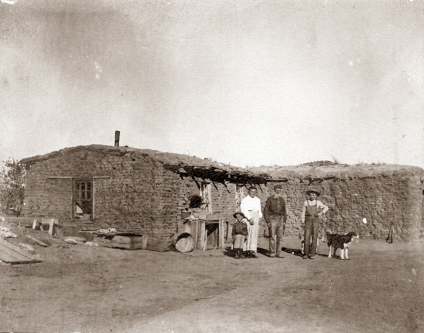
Henry Sitler in later years, and his sod house in 1871

In 1871, rancher Henry L. Sitler built a sod house about five miles west of the fort, which became a stopping place for those traveling on the Santa Fe Trail, and a year later, a town was platted and George M. Hoover set up a tent to sell liquor to the soldiers at the fort. The Atchison, Topeka and Santa Fe Railway arrived in town later that year and things picked up quickly.

At first it was the trade in buffalo hides that built Dodge City, with the bones and skins of the buffalo sent by rail back to the east. Indeed, the settlement was first named Buffalo City. 

Buffalo hides at Dodge City

When cattle from Texas needed to be shipped to eastern markets, towns were established along the route of the railroad. In Kansas, first in Abilene, in 1867. An outbreak of cattle fever led to a quarantine line in the state, and the railhead moved further and further west, reaching Dodge City in 1876, roughly the years when fictional Marshal Dillon ruled the town. 


From 1875 to 1886, some 5 million beeves were herded up the trail from Texas to Kansas railheads. In 1877 alone, Dodge City was the largest of the cattle-shipping boom towns, loading up and shipping out 500,000 head of cattle.

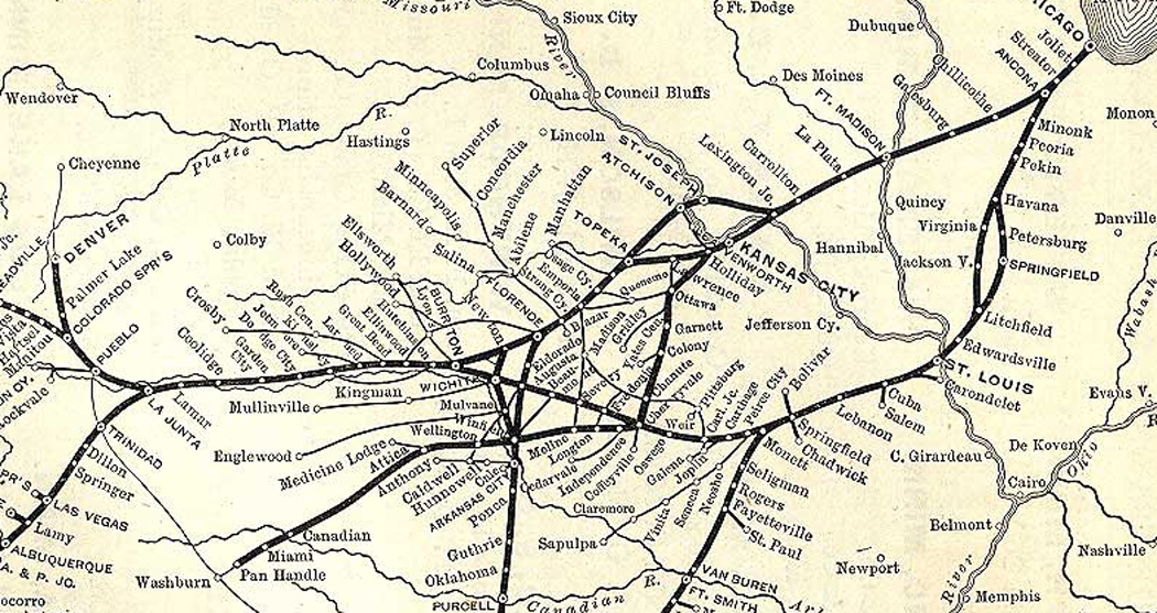
Route of the AT&SF Railway that got the beef to the slaughterhouses and meatpacking industry of Chicago

As Dodge City grew, and Kansas became more populated, the need for a fort on the Santa Fe Trail became less important, and by the end, when the fort closed in 1882, it was garrisoned by only about a dozen soldiers. The remaining buildings were later turned into a home for retired soldiers. 

Dodge City, 1872

This was the milieu that the fictional Dodge City supposedly took place in.

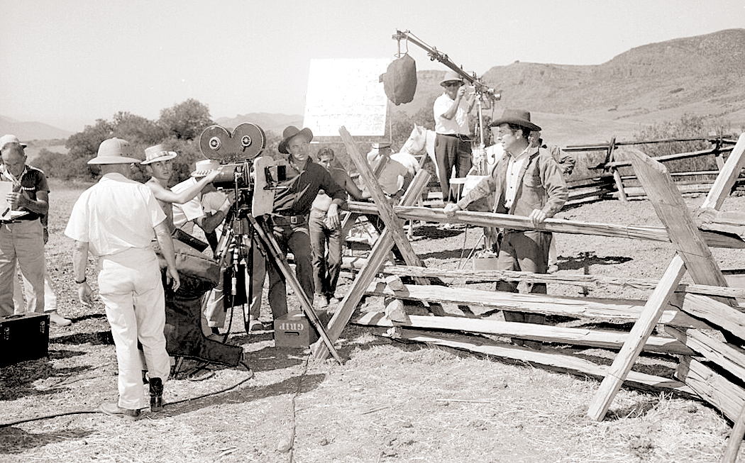
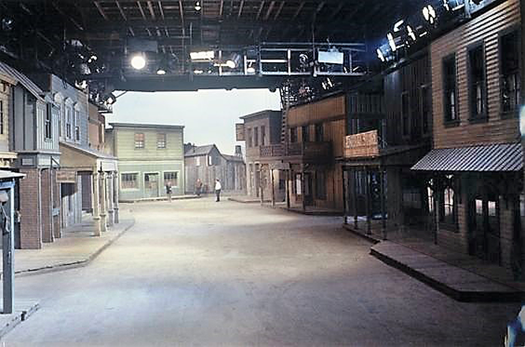
Gunsmoke remained on TV for 20 years and the town barely changed, despite having moved from its original outdoor location shooting to being filmed on fabricated sets in the studio. 

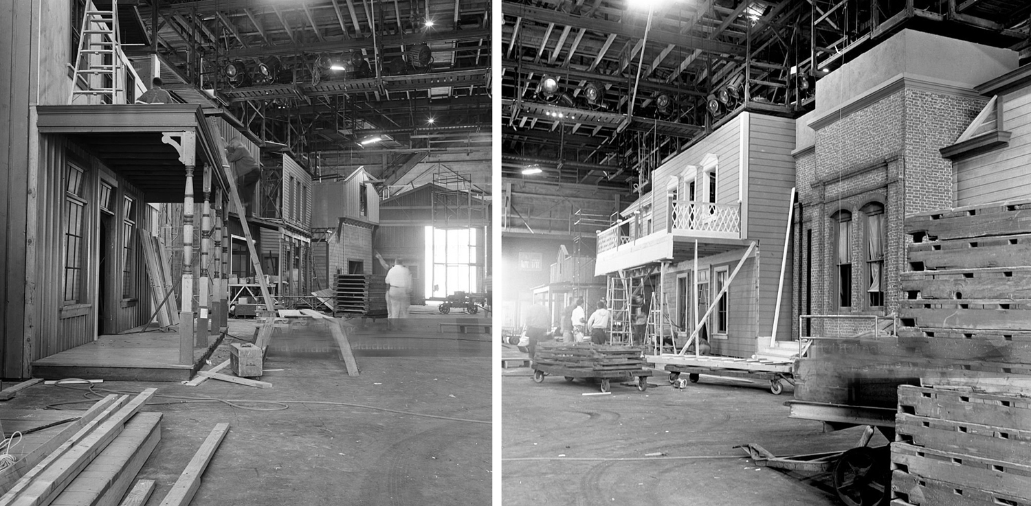
Constructing Dodge City in studio for “Gunsmoke”

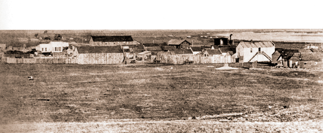
The actual town grew and changed continuously, beginning in 1871 with a population of 1 — as Henry Sitler built a sod house in the location five miles from Fort Dodge — to a population near of 1200 just five years later and to 1,763 by the 1890 census. TV’s Dodge City should have been filled with ongoing construction. The trains not only took cattle out of Dodge, but brought in supplies and lumber to build the town in a region mostly devoid of timber. 

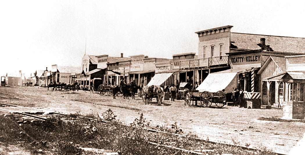
The town was incorporated and platted in 1872, and George Hoover moved to a wood building on Front Street to serve thirsty Fort Dodge soldiers, buffalo hunters and the increasing number of cattle herders. 

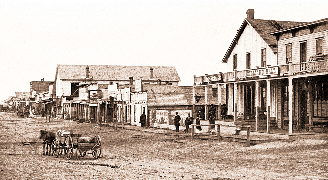
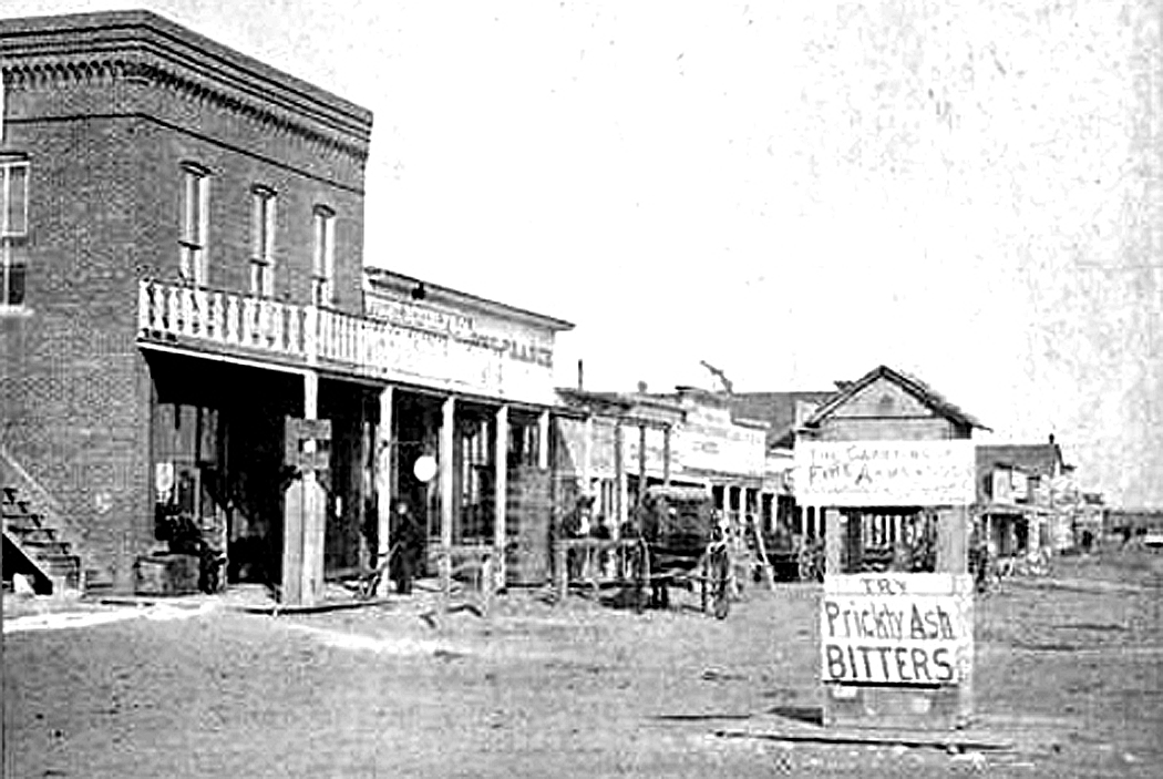
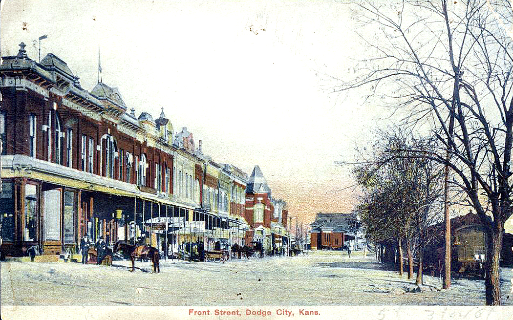
Front Street, Dodge City, 1872

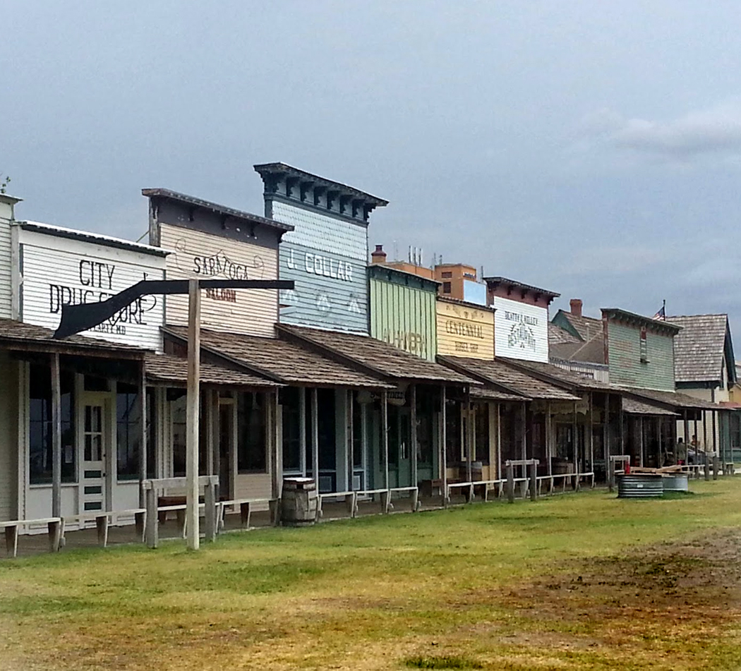
Gunsmoke’s Dodge City was a standard-issue Western town, like those of so many other towns in other TV series and movies — a wide dirt street with wood-frame buildings on both sides. 

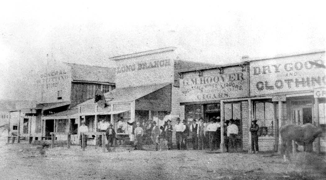
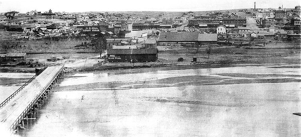
The reality of Dodge City was that it was built alongside the Arkansas River, where the Santa Fe Trail paralleled the river. When the railroad came, it, too, followed the river. The town then grew on the far side of the tracks, leaving the town plan with the river to the south, the tracks to the north, and Front Street and the primary businesses in a single row on the north side of the street, as shown in this detail of the bird’s-eye view map, from 1882.


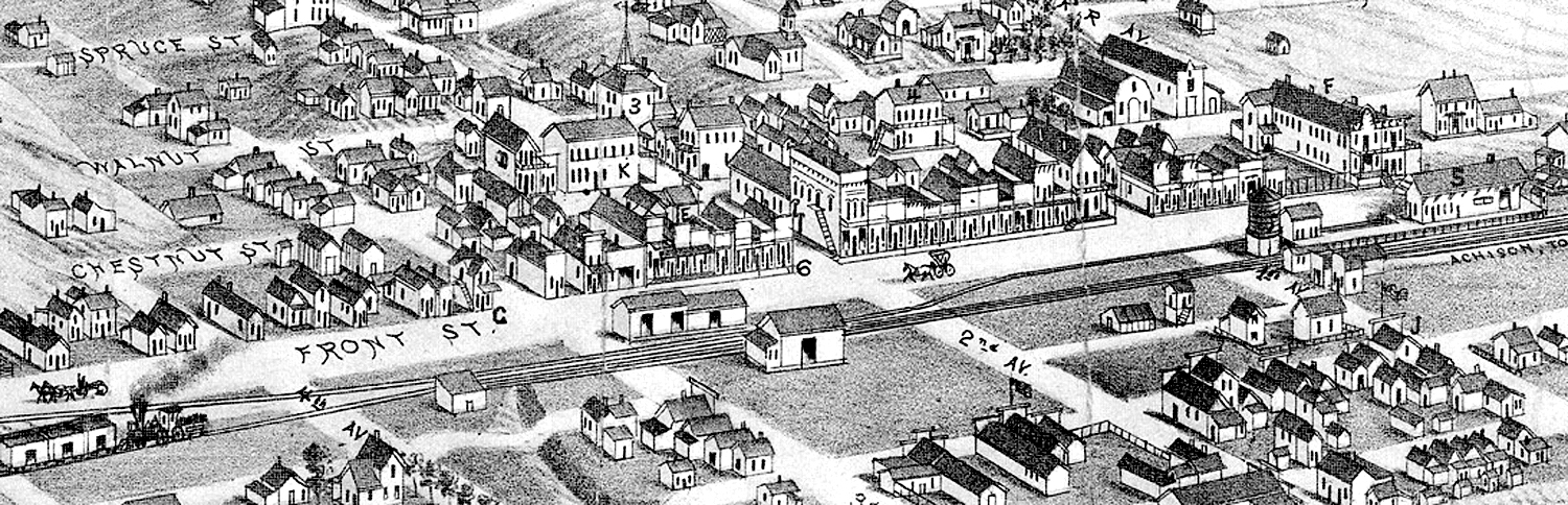
This was a common city plan, and can be found all across both the West and the South, wherever a town grew alongside railway tracks. Tracks; road; storefronts, in that order. 

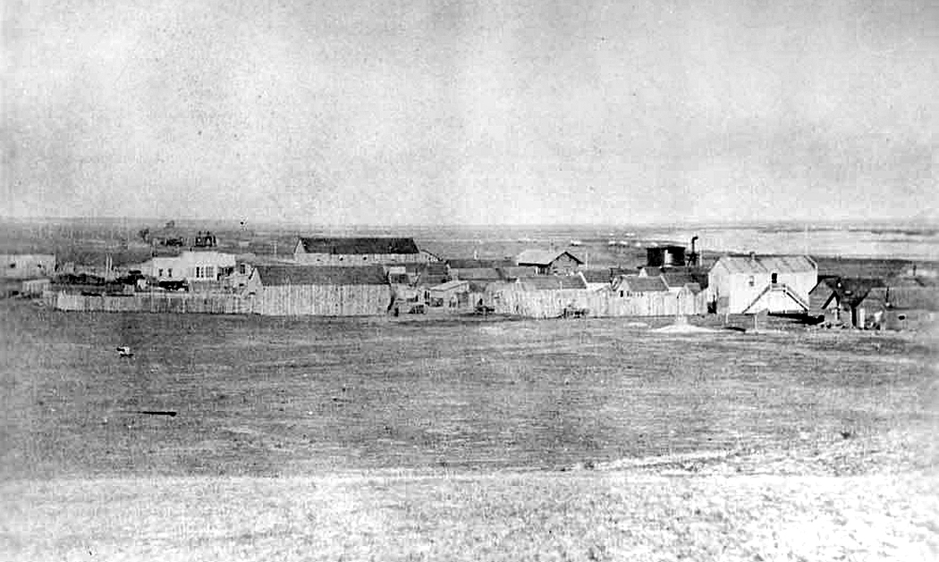
Winter 1872, Dodge City

Sidenote No. 2

The constant growth of the town from 1871 to 1900 means that there is no single version of Dodge City to be had. It was always changing. Over the two decades of Matt Dillon’s TV tenure, the place barely changed a whit, although Dillon did. James Arness was 32 with a boyish face when the series began. When the series ended, he was in his 50s. Gunsmoke movies continued to be made, and by the time of the last, Gunsmoke: One Man’s Justice, from 1994, Arness was 71, which, if we insist on a concurrent timeline, puts the movie’s action into roughly 1914. 

The TV show seems to remain static in time, other than the persistent aging of its inhabitants, but if we pretend the town aged as the actors did, the final episodes would have taken place in the 1890s. By then the cattle drives were long over, the town had settled into domesticity, and the six-guns and stetsons were relics of the past. The most common hat worn by men in Dodge city was a bowler. 

Back to the main story
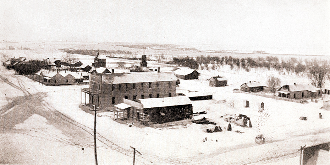
Dodge City, 1873

In the group of photos I collected, I found records of many of the town’s inhabitants, and they tell a story of Dodge City’s growth and character. I wanted to share a few of them. I purposely did not include information on several of the more mythic figures that are frequently dredged out to tell the tale. You can find all kinds of stories about Wyatt Earp, Doc Holliday, Dora Hand or Bat Masterson, and they have all been through the Dime Novel, Hollywood movie, TV series myth-making machine and many of their stories are questionable at best. Many conflicting versions abound. 

So, I wanted to mention George Hoover, Chalk Beeson, Ben Hodges, Thomas McCarty, James “Dog” Kelley, Ormond Wright, and Squirrel Tooth Alice, among others, all of whom are central to Dodge City’s history. 

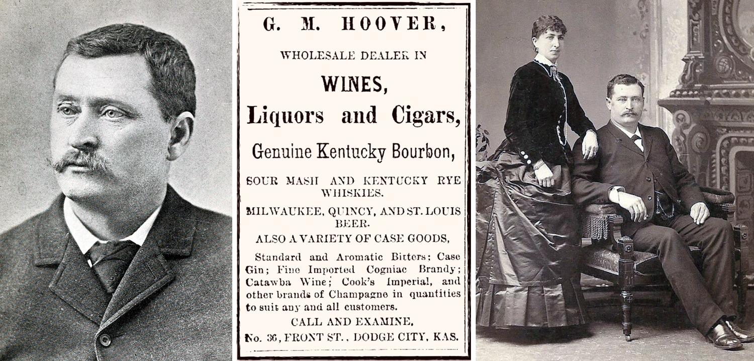
George Hoover and wife, Margaret

Hoover was the second person, after Henry Sitler, to settle on the site of what would become the town, in 1872 and set up a bar to serve travelers and the soldiers of Fort Dodge. He sold whisky by the ladle for 25 cents (equivalent value today: about $20.) At the time, alcohol was forbidden at Fort Dodge and for a radius of five miles, which is why Hoover’s tent-and-wood-plank bar was opened where it was and Dodge City took hold five miles from the fort. 

Hoover became the town’s first elected mayor, reelected three times, became a state legislator, and, after many successful businesses, opened the town’s first bank. He died in 1914, a few months after his wife, Margaret, died. He said, according to the July 16, 1914, Dodge City Globe, “that he had but little desire to live longer, and declared that life had no more interest for him [after his wife’s death].”

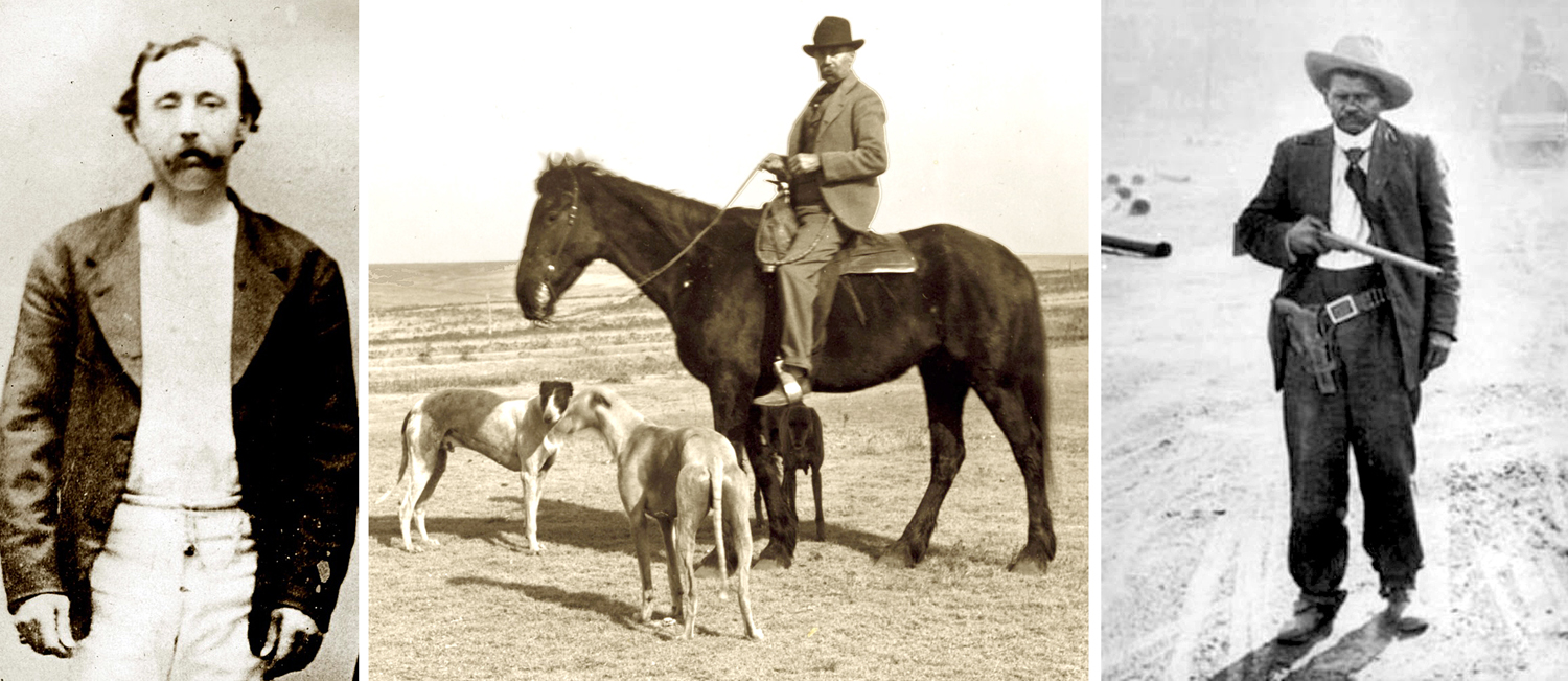
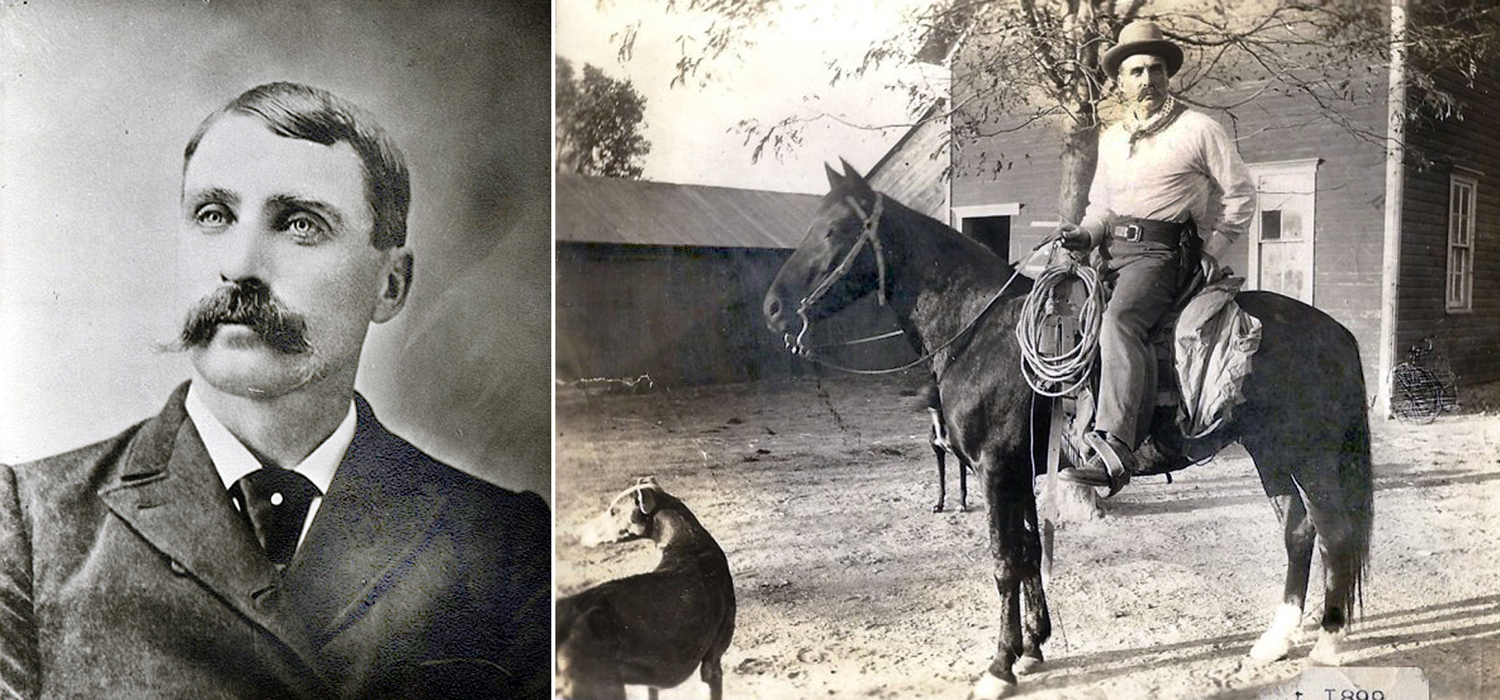
James Kelley, Kelley on horse, and Ben Hodges

British-born James Kelley was mayor of Dodge City from 1877 to 1881. He was part owner of the Beatty and Kelley Restaurant and kept a tamed black bear, named Teddy, behind the shop. Kelley had a white horse and often wore a white corduroy suit and kept a bunch of greyhounds, hence his nickname, “Dog” Kelley. His restaurant burned down in 1885 and he opened up the Kelley Opera House on the corner of Front Street and First Avenue. Kelley died in 1912, having spent his last years at the soldiers’ home at the former Fort Dodge. 

Dodge City, 1878

Ben Hodges was half-Mexican, half Black and a cook’s helper on a cattle drive, who stopped in Dodge in 1872 and began a series of (unsuccessful) land-deal swindles and claims to wealth and nobility. He lived for years in a little shack on the south side of town, near the river and kept young boys fascinated with his tall tales. The town seems to have tolerated Ben as the “town character.” He was made an “Assistant Deputy” and allowed to carry a gun, minus the firing pin and his shoplifting of food from stores was accepted since, “he only took what he needed.” 

When he died, in 1929, a collection was raised to buy him a plot in the elite Catholic cemetery rather than a pauper’s grave. According to one pall bearer, “We wanted him where they could keep an eye on him.” 

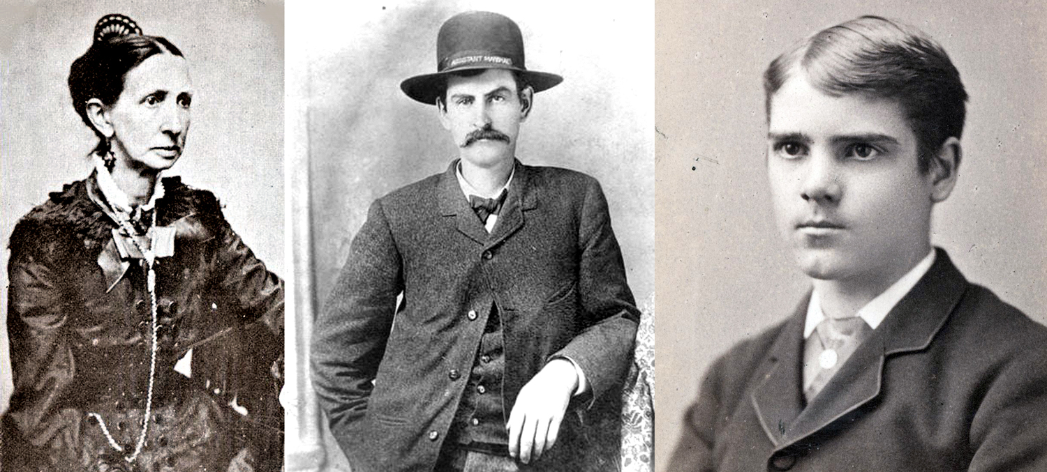
Larry Deger and T.L. McCarty

Dodge City’s original Matt Dillon and Doc Adams were Marshal Lawrence Deger and Dr. Thomas McCarty. Deger was the first marshal of the town. 

From 1871 till it was incorporated in 1875, Dodge City had no law officers, and things were quite chaotic, with a number of murders gone unaddressed until a vigilance committee was formed. Unfortunately, the committee soon became the source of violence and the Kansas governor appointed Charles Bassett sheriff of Ford County in an attempt to establish some order. It is estimated that between 1872 and 1876, some 70,875 gallons of whiskey were consumed in Dodge City, which is the equivalent of approximately or 4,536,000 individual shots — a lot for a town of about a thousand citizens.

St. James Saloon, Dodge City

In 1875, Deger was appointed marshal by the town council (there is some confusion in the popular mind, as a U.S. marshal is a federal employee, while a city marshal is essentially the police chief and is hired by local government. However, in some locations, marshals were elected — it’s all quite confusing. Sheriffs are usually politicians, who are elected). Deger was a saloon keeper and took sides in a developing confrontation among townspeople between those who wanted a more open town to provide booze and professional women to cattle drivers, i.e. “good for business,” and those who wanted a quieter, more civilized town. Deger wanted peace. 

What ensued in 1873 is sometimes called the Saloon Wars and sometimes the Dodge City Wars. Deger was by that time mayor and had laws passed establishing prohibition and outlawing prostitution. It was also suggested, for instance, “We should have an ordinance prohibiting the firing of guns within the city limits.” And, “We should have a law not allowing the riding of horses over sidewalks and into the saloons.”

In the course of these reforms, three “singers” at the Long Branch saloon were arrested, but none of the workers at other saloons were also nabbed. Favoritism was charged and the pro-business group, called “the gang,” hired a bunch of former lawmen as muscle for their side of the argument. 

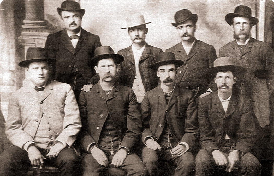
Dodge City Peace Commission

A famous photo of the group was made at the time, with (standing L-R: William Harris; Luke Short; Bat Masterson; William Petillon. And seated, L-R: Charlie Bassett, Wyatt Earp; Frank McLean; and Neil Brown.) 

The sides stared each other down, but it was finally resolved without gunfire, and the Long Branch was allowed to reopen. But women in the profession were moved south of the railroad to the “wrong side of the tracks.” 

Varieties Dance Hall, Dodge City

Deger married German-born Etta Engleman in 1883, and moved to Texas where he operated a lumber company. He died in 1924. 

Thomas McCarty, his wife, Sarah, and Sing Lee

McCarty was the town’s first civilian doctor and Ford County’s first coroner. He and his wife, Sarah, arrived in Dodge City in 1872, on their way further west, but stayed in town. He operated his surgery and partnered in a drug store with Herman Fringer and later opened his own, called City Drug Store. 

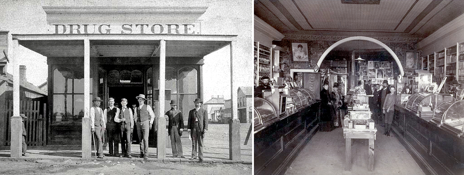
City Drug Store, 1877

McCarty’s son, Claude, was reputedly the first legitimate baby born in Dodge City, and later also became a doctor and with his father opened the McCarty Hospital in 1905, remodeling the old four-story Central Hotel.

The doctor’s household included a servant named Sing Lee, who wore the traditional Chinese queue.  

Dr. Thomas McCarty died in 1930, ten years after his wife Sarah.  His son lived until 1950.


Chalkley Beeson

Chalk Beeson came to Dodge in 1874 with his wife, Ida. Soon, he received the Billiard Hall Saloon as payment for a debt and renamed it the Saratoga, one of the few that didn’t employ prostitutes. Instead, he featured a five-piece band, with himself as leader on the fiddle. In 1877, the Dodge City Times wrote, “It is a rare treat to drop in at the Saratoga upon Mr. Beeson, and listen to his last and best musical combination. Mr. Beeson is a thorough lover of good music, and by his skillful selection of good performers … draws crowds of attentive listeners.” 


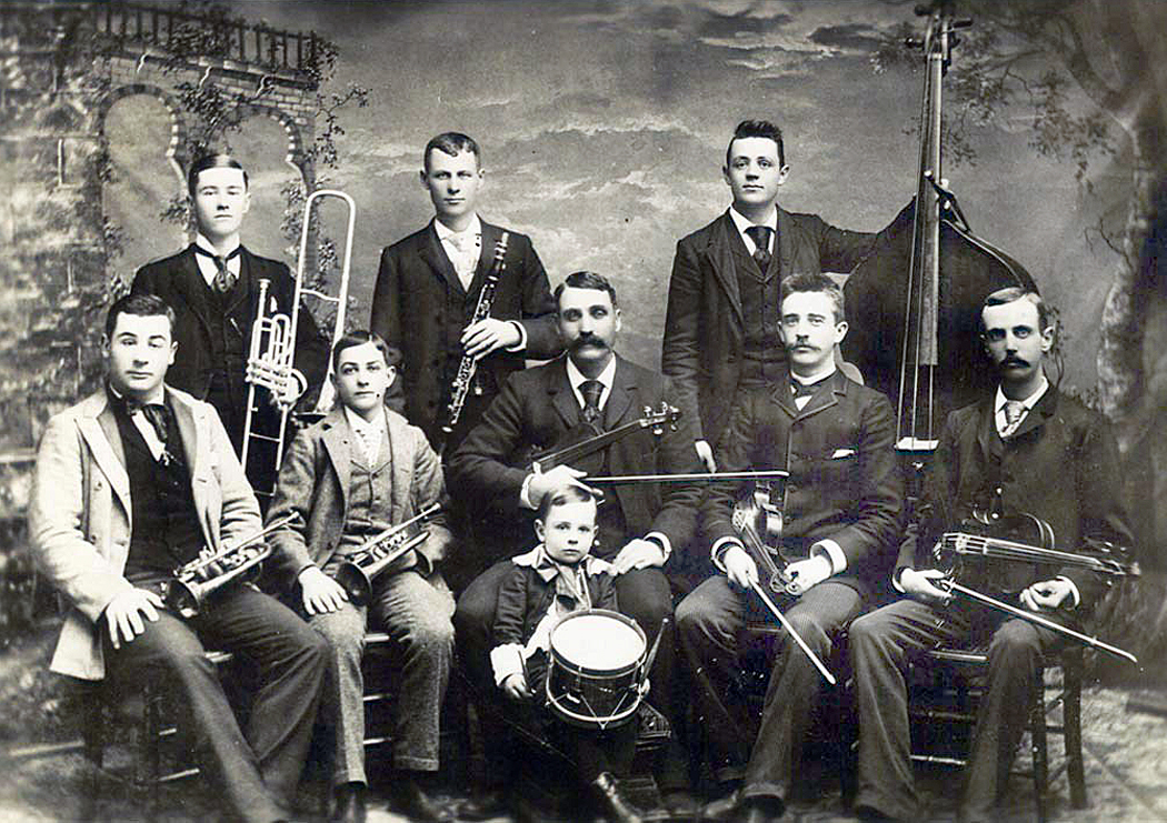
Dodge City Cow-Boy Band, Beeson in center with fiddle

In 1884, he expanded his band to form the Dodge City Cow-Boy Band and toured, including an appearance in the inaugural parade of President Benjamin Harrison in 1889. 

Beeson was later elected sheriff of Ford County and in 1903, elected to the state legislature. He died in 1912 when he was kicked by his horse. 


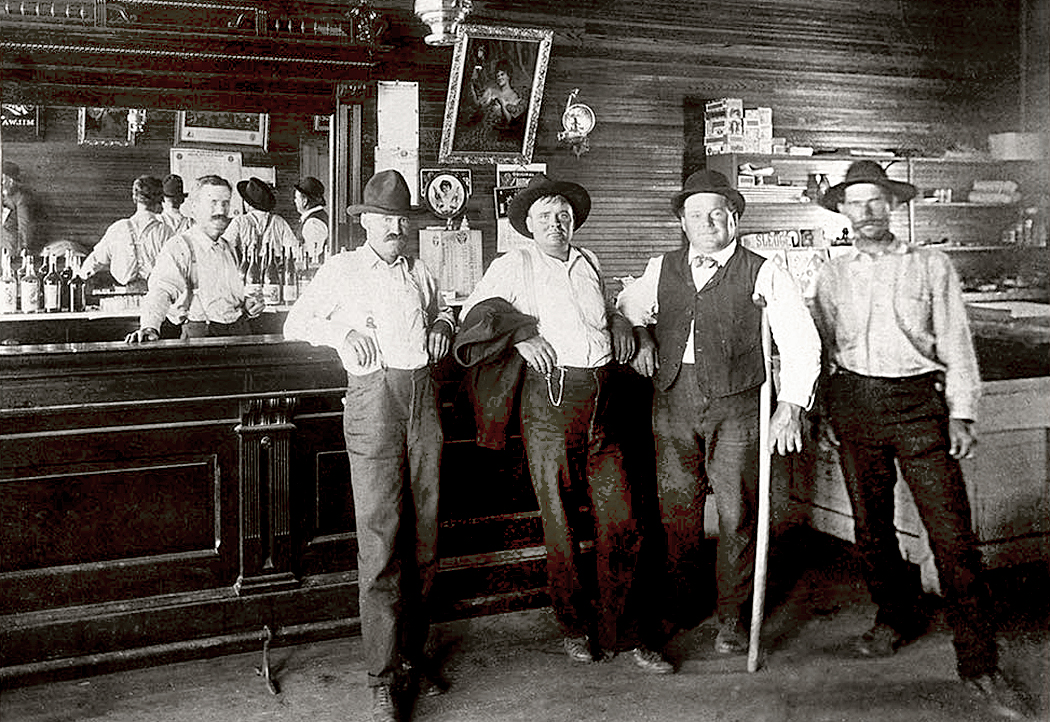
By the middle 1870s, there were a little over 1000 residents in Dodge City but 16 saloons. In addition to the Long Branch and the Saratoga were the Alamo, the Alhambra, the Crystal Palace, the Lone Star, the Oasis, Congress Hall and the Green Front. Some of them just one-room storefronts. 

A reporter from the Hays City Sentinel wrote of Dodge City at the time, “The employment of many citizens is gambling. Her virtue is prostitution and her beverage is whisky.” On TV, the saloon girls share drinks with cowboys, but, as one writer put it, “Miss Kitty wasn’t selling chocolate bars.” We know the names of several of these hard-working women. 


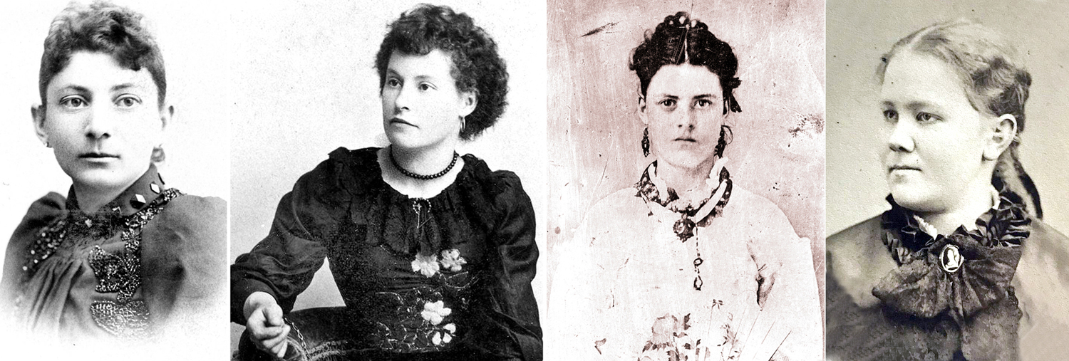
L-R: Sadie Ratzell; Squirrel Tooth Alice; Timberline; Mattie Blaylock

Sarah “Sadie” Ratzell was born in Philadelphia but grew up on a Kansas farm. When she was 18, she became a prostitute and lived with a Dodge City dance hall owner in the 1880s. 

In July, 1881, she complained to then-Marshal Fred Singer about a man prowling around her home after dark. Singer found and shot 23-year-old Joseph McDonald hidden in a growth of sunflowers. A coroner’s inquest that followed notes “the latter raised his arm horizontally, as though in the act of firing. The marshal apprehended some danger from this movement, and not knowing whether the man had a pistol or not, raised his weapon and fired, the shot striking McDonald in the hand and passing into his right side, causing death in three hours.” Singer later resigned as marshal and opened saloon, which occupation he said was more financially rewarding. 

Front Street with Long Branch Saloon, 1875

Squirrel Tooth Alice was born Mary Elizabeth Haley in 1855 in Texas. She was kidnapped by Comanches in 1864 and ransomed three years later.  She ran away from home at 14 to become a dance-hall girl and prostitute. She hooked up with”Texas Billy” Thompson. In 1873, Thompson shot and killed the sheriff in Ellsworth, Kan., but escaped from jail and fled to Dodge City, where she took up her trade. Later the pair, by then married, moved to Colorado and later, Texas. She was known as Squirrel Tooth after a gap in her front teeth. She also kept pet prairie dogs on leash and collar. As Libby Thompson, she had nine children by several men, while running a brothel. She died in California in 1953 at the age of 97. 

Rose Vastine was known as Timberline because she was 6”2’ and worked in Dodge City in the 1870s. According to one account, she was suicidal, and while later living in Creede, Colo., shot herself six times, but lived. “She made yet another attempt to shoot herself in the chest in 1893. ‘Medical attendants were at once summoned and the would-be suicide is in a fair way to recovery,’ said the newspaper.” Little else is known. 

Dodge City, 1879

Celia Ann Blaylock was born in Iowa in 1850. When she was 18, she ran away from home and found her way, as Mattie Blaylock, to Dodge City, where she became a prostitute. In 1876, she took up with city deputy marshal Wyatt Earp and for six years lived as his common-law wife while maintaining her profession. She suffered from extreme migraines and became addicted to laudanum as a pain killer. She left Dodge City with him in 1879, going to New Mexico, and then to Tombstone, Ariz. Eventually Earp left her, and in 1888, she died from an overdose, ruled by the coroner as “suicide by opium poisoning.” She was 38.

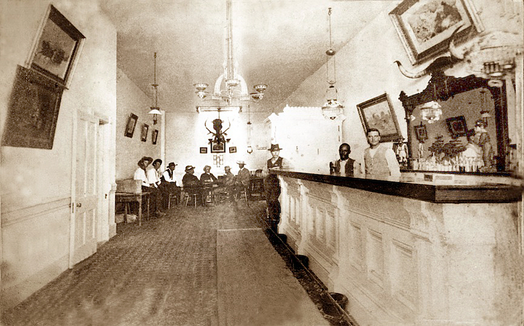
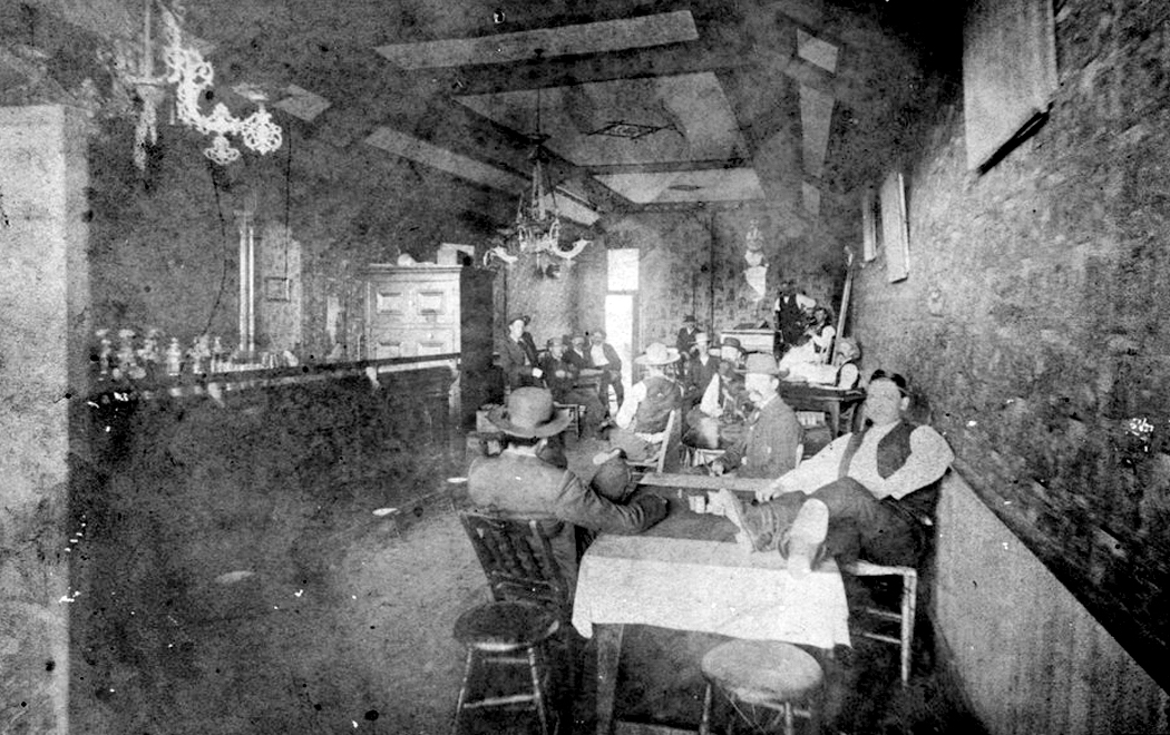
Interior, Long Branch Saloon

The Long Branch has become the most famous, although there never was a Miss Kitty. It was established in 1874 and named for its owner’s hometown of Long Branch, N.J. It passed through several hands and in 1878, Beeson bought a share in it. He sold his portion in 1883 to Luke Short. 


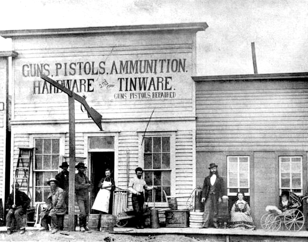
Zimmerman’s hardware store

Two years later, it burned down in a fire that destroyed much of Front Street, taking out in addition, Dog Kelley’s Opera House, Charles Heinz’s Delmonico restaurant, the York, Parker, Draper Mercantile Company, F.C. Zimmermann’s hardware store and even the first brick building in town, Robert Wright’s store, which held out long enough to retrieve a good deal of his merchandise before the building went. But, as the newspaper reported, “Some awful good whiskey was allowed to burn up.”

That fire, and a second, smaller one a month later, led the city council to establish a fire department and a city water works, with fire hydrants around the city. 

Robert M. Wright and his book

There are many more citizens of Dodge back then, and I can’t include them all. One early resident (and later mayor — they all seem to have taken turns as mayor) was Robert Wright, who, in his old age, wrote a book called, Dodge City, the Cowboy Capital and the Great Southwest in The Days of The Wild Indian, the Buffalo, the Cowboy, Dance Halls, Gambling Halls, and Bad Men, published in 1913. It is loaded with familiar stories of the early times in Kansas, but also argues that it wasn’t as bad as all that. He tries to put a clean face on the popular image. (I have read it; let’s just say, Wright was not a graceful writer — it’s a tough slog). Wright dies two years after his book was published. 

L-R: Margaret Walker; Dave Mather; Rev. Ormond Wright

Among the many people I have had to leave out of this blog entry are  Margaret Walker, the town’s first schoolteacher; “Mysterious Dave” Mather, who owned the Opera House Saloon and was the survivor of one of the more famous gunfights in town; Rev. Ormond Wright, who presided over the first church built in Dodge, a non-denominational worship. 

Dodge City, 1887, with Arkansas River

There were enough documented personalities from the early years of Dodge City, that a TV series could have been made without resorting to the fictions of Matt, Doc, and Kitty. (I mean no slight on Gunsmoke, which, especially in its early years did truly attempt to be more faithful to the spirit, if not the fact of its times, and was often extremely well written.)


Dodge City, 1890s

 Dodge City went from tents and sod to wood frame buildings and to multi-story brick in a little over ten years, in the process building institutions, electing a town council and mayor, and hiring a police force, so  that, when the cattle industry largely disappeared in the 1880s, it was prepared to be a self-sustaining community. The real town was a dynamic entity; on TV, it was just a stage set. 

Click any image to enlarge

When I was a wee lad, in the 1950s and television was about the same age, I watched the images on the screen flash by with no critical eye. It was all the same: old movies, kiddie shows, talk shows, variety shows, sitcoms — it all wiggled on the toob and that was enough. 

If there were any difference in production quality, or acting ability, it made no difference. I just watched the story, or listened to the music. The very idea that there were people behind the camera never occurred. I didn’t really even think about there being a camera. Things just appeared. I suspect this is true for most kids. It may be true for quite a few grown-ups, too. 

There were certainly programs I liked more than others, but I could not have given any reason why one and not the other. Mostly, in the daytime, I watched cowboy movies and cartoons, and in the evening, I watched whatever the rest of the family was watching. 

In all that, there were a good number of Westerns. There were those for the kids, such as The Lone Ranger or The Cisco Kid, and later, those in the after-dinner hours aimed at the grown-ups — Gunsmoke or Death Valley Days. There were also the daytime screenings of old Western movies with such stars as Buck Jones, Hoot Gibson, Bob Steele or Johnny Mack Brown. 

I mention all this because I have recently begun watching a series of reruns of old TV Westerns on various high-number cable channels, seeing them in Hi-Def for the first time. I have now seen scores of original Gunsmoke episodes and my take on them is entirely different from when I was in grammar school. I can now watch them critically.

It’s been 70 years since I was that little kid, and since then I’ve seen thousands of movies and TV shows, served a stint as a film critic, written about movies, and introduced films in theaters. I have a different eye, and understand things I couldn’t know then. 

And so, a number of random thoughts have come to me, in no particular order:

1. 

Old TVs were fuzzy; new TVs are sharp. In the old days of cathode-ray tubes, TV pictures were made up of roughly 480 lines, running from top to bottom of the screen, refreshing themselves every 60th of a second. Broadcast TV was governed by what is called NTSC standards (altered slightly over time). Such images were of surprisingly low definition (by modern standards). 

The sharpness of those early TV pictures was not of major importance because most people then really thought of television as radio with pictures, and story lines were carried almost entirely by dialog. The visual aspect of them was of minor concern (nor, given the resolution of the TVs at the time, should it have been.)

Of course, now, we watch those old Gunsmoke episodes on HD screens. And two things become apparent. 

First, is that shows such as Gunsmoke were made better than they needed to be. They were made mainly by people trained in the old Hollywood studio system, where such things as lighting, blocking, focus, camera angles, and the such were all worked out and professionally understood. They were skilled craftsmen. 

However, second, some things were designed for analog screens, and so, often, painted backdrops used, especially for “outdoor” scenes shot in the studio, have become embarrassingly obvious, when, originally, they would have passed unnoticed on the fuzzy screen. 

Outdoor scenes were often shot in studios. Dodge City, during some seasons, was built indoors and the end of the main street in town was a backdrop. Again, on the old TVs you would not notice, but today, it’s embarrassing how crude that cheat was. 

You can see it in the opening shootout during the credits. In early seasons, Dillon faces the bad guy outdoors. In later seasons, he’s in the studio. 

2. 

Because Gunsmoke is now seen on a widescreen HD screen, but were originally shot for the squarer 4-by-5 aspect ratio, the image has to be rejiggered for the new screen. There are three ways of doing this, and as they show up on current screens, they are either shown with black bars on either side of the picture, to retain the original aspect ratio, or they are cropped and spread out across the wider 16:9 space. And if so, there are two ways this happens. 

If the transfer is done quickly and cheaply, the cropping is done by just chopping off a bit of the top and bottom of the picture, leaving the middle unchanged. The problem is this often leaves the picture awkwardly framed, with, in close ups, the bottoms of characters’ faces left out. 

However, in some of the newly broadcast Gunsmokes, someone has taken care to reframe the shots — moving the frame up or down — so as to include the chins and mouths of the characters. To do this, the technician has to pay attention shot by shot as he reframes the image. 

And so, it seems as if the Gunsmoke syndications have been accomplished either by separate companies, or at different times for different series packages. You can see, for instance, on the INSP cable network, examples of all three strategies. (My preference, by far, is for the uncropped original squarer picture.)

3. 

Gunsmoke changed over its 20-year TV run. There are three main versions: Black and white half-hour episodes (1955-1961); black and white hour-long episodes (1961-1966); and hour-long color episodes (1966-1975). The shorter run times coincided with the period when Dennis Weaver played Matt Dillon’s gimpy-legged sidekick Chester Goode. Chester continued for a season into the hour-longs, but was replaced by Ken Curtis as Festus Haggen, the illiterate countrified comic relief. 

Technically, the black and white seasons were generally better made than the color ones. When the series began, TV crews had been those previously at work in cinema, and brought over what they learned about lighting, framing, editing, blocking, use of close-ups. The black and white film stock allowed them to use lighting creatively, using shadows to effect, and lighting faces, especially in night scenes, with expressive shadows. Looking at the older episodes, I often admire the artistry of the lighting. 

But when color came in, the film stock was rather less sensitive than the black and white, and so the sets had to be flooded with light generally for details to be rendered. This led to really crass generic lighting. Often — and you can really spot it in night scenes — a character will throw two or three shadows behind him from lights blasting in different directions. Practicality drowns artistry. 

Gunsmoke wasn’t alone in this: This bland lighting affected all TV shows when color became normal. It took decades — and better film stock — before color lighting caught up. (One of the hallmarks of our current “golden age” of TV is the cinematic style of lighting that is now fashionable. Color has finally caught up with black and white.) 

4. 

One of the pleasures of watching these reruns is now noticing (I didn’t when I was a little boy) the repertory company of actors who showed up over and over again, playing different characters each time. 

I’m not just talking about the regular actors playing recurring roles, such as Glenn Strange as Sam the barkeep or Howard Culver, who was hotel clerk Howard Uzzell in 44 episodes, but those coming back over and over in different roles. Victor French was seen 18 times, Roy Barcroft (longtime B-Western baddie) 16 times; Denver Pyle 14 times, Royal Dano 13 times, John Dehner, John Anderson and Harry Carey Jr. a dozen times each.

Other regulars with familiar faces include Strother Martin, Warren Oates, Claude Akins, Gene Evans, Harry Dean Stanton, Jack Elam. Some were established movie actors: George Kennedy, Dub Taylor, Pat Hingle, Forrest Tucker, Slim Pickens, Elisha Cook Jr., James Whitmore. Bette Davis, too. 

William Shatner, Leonard Nimoy, DeForest Kelley, James Doohan

And a few surprises. Who knew that Leonard Nimoy was in Gunsmoke (four times), or  Mayberry’s George Lindsay (six times — usually playing heavies and you realize that the goofy Goober Pyle was an act — Lindsay was an actor, not an idiot), Mayberry’s barber Howard McNear showed up 6 times. Jon Voight, Carroll O’Connor, Ed Asner, Harrison Ford, Kurt Russell, Suzanne Pleshette, Jean Arthur, DeForest Kelley, Werner Klemperer (Colonel Klink), Angie Dickenson, Dennis Hopper, Leslie Nielsen, Dyan Cannon, Adam West, and even William Shatner — all show up. 

It becomes an actor-spotting game. John Dehner, in particular, was so very different each time he showed up, once a grizzled old miner, another a town drunk, a third as an East-coast dandy, another as a hired gunslinger — almost never looking or sounding the same. “There he is, Dehner again!” 

And it makes you realize that these were all working actors, needing to string together gigs to make a living, and the reliable actors would get many call-backs. It is now a pleasure to see how good so many of these old character actors were. 

5. 

I have now watched not only Gunsmoke, but other old TV Westerns, and the quality difference between the best Gunsmoke episodes and the general run of shows is distinct. While I have come to recognize the quality that went into the production of Gunsmoke, most of the other shows, such as Bonanza, simply do not hold up. They are so much more formulaic, cheaply produced, and flat. Stock characters and recycled plots. 

Gunsmoke was designed to be an “adult Western” when it was first broadcast, in 1952, as a radio show, with stocky actor William Conrad as Matt Dillon. In contrast to the kiddie Westerns of the time, it aimed to bring realism to the genre. 

William Conrad as Marshal Dillon

It ran on radio from ’52 to 1961, and on TV from 1955 to 1975, and then continued for five made-for-TV movies following Dillon in his later years. There were comic books and novelizations. Dillon became a household name.

Originally, Matt Dillon was a hard-edged, lonely man in a hard Western landscape. As imagined by writer and co-creator of the series John Meston, the series would overturn the cliches of sentimental Westerns and expose how brutal the Old West was in reality. Many episodes were based on man’s cruelty to both men and women. Meston wrote, “Dillon was almost as scarred as the homicidal psychopaths to drifted into Dodge from all directions.” 

On TV, the series mellowed quite a bit, and James Arness was more solid hero than the radio Dillon. But there was still an edge to the show, compared with other TV Westerns. After all, according to True West magazine, Matt Dillon killed 407 people over the course of the TV series and movie sequels. He was also shot at least 56 times, knocked unconscious 29 times, stabbed three times and poisoned once. 

And the TV show could be surprisingly frank about the prairie woman’s life and the painful treatment of women as chattels. 

In Season 3 of the TV series, an episode titled “The Cabin,” two brutal men (Claude Akins and Harry Dean Stanton) kill a woman’s father and then serially beat and rape her over the course of 35 days, when Dillon accidentally comes upon the cabin to escape a snowstorm. The thugs plan to kill the marshal, but he winds up getting them first. When Dillon suggests that the woman can now go back to living her life, the shame she feels will not let her. No one has to know what has happened here, he tells her, but, she says, she will know. And so she tells Dillon she will go to Hayes City, “buy some pretty clothes” and become a prostitute. “It won’t be too hard, not after all this,” she says. 

“Don’t let all this make you bitter,” Dillon says. “There are a lot of good men in this world.”

“So they say” she says. 

This is pretty strong stuff for network TV in 1958. There were other episodes about racism, and especially in the early years, not always happy endings. 

Dodge City, 1872

6. 

According to Gunsmoke producer John Mantley, the series was set arbitrarily in 1873 and in Dodge City, Kansas, on the banks of the Arkansas River, although the river plays scant role in the series. In 1873, the railroad had just arrived, although in only a few episodes of the TV series is the train even mentioned. 

The Dodge City of the series is really just a standard Hollywood Western town, with the usual single dusty street with wooden false-front buildings along either side. 

In reality (not that it matters much for a TV show, although Gunsmoke did try to be more realistic than the standard Western), Dodge was built, like most Southern and Western towns, with its buildings all on one side of the street (called Front Street in Dodge) and the railroad tracks on the other. Beyond that, the river. 

Dodge City, Kansas 1888

And in general, the geography of Gunsmoke’s Kansas would come as a surprise to anyone visiting the actual city. The state is famously flat, while the scenery around Matt Dillon often has snow-capped mountains, and at other times, mesas and buttes of the desert Southwest. 

Hollywood’s sense of geography is often peculiar. So, I don’t think it is fair to hold it against the TV series that its sense of the landscape has more to do with California (where the series was generally shot) than with the Midwest prairies. 

I remember one movie where James Stewart travels from Lordsburg, N.M., to Tucson, Ariz., and somehow manages to pass through the red rocks or Sedona on the way. Sedona is certainly more picturesque than Wilcox, Ariz., but rather misplaced.

Or John Ford’s The Searchers, where the Jorgensen and Edwards families are farming in Monument Valley, Ariz., which has no water, little rain, sandy soil and no towns within a hundred miles. It is ludicrous place to attempt to farm. Of course, it is said, in the movie, to be set in Texas, but Texas doesn’t look like the Colorado Plateau at all. 

We forgive such gaffes because the scenery is so gorgeous, and because we’ve been trained by decades of cowboy movies to have a picture of “The West” as it is seen in Shane rather than how most of it actually was: flat, grassy, and boring. And often, it is not even the West, as we think of it. Jesse James and his gang robbed banks in Missouri. The Dalton Gang was finished off in Minnesota. The “hanging judge” Parker presided in Arkansas. Some of the quintessential Western myths are really Midwestern or Southern. 

So, many of the tropes of Hollywood Westerns still show up in Gunsmoke, despite its attempt at being “more realistic” than the standard-issue cowboy show. 

“Gunsmoke” studio set

Two things, however, that are hardly ever mentioned that seems germane to the question of realism on film. The first is the pristine nature of the streets. Historians have shown that, with all the horses, not only in Westerns, but even in 19th-century Manhattan, the streets were paved with horseshit. Cities even hired sanitation workers to collect the dung in wheeled bins, so as not to be buried in the stuff. 

OK, I get that perhaps on TV shows broadcast into our homes, we might not want to see that much horse manure. In reality, the dirt dumped in the studio set of Dodge City had to be cleaned out, like kitty litter, each day, or under the hot lights, the whole set would stink of horse urine. 

But the second issue relates to the very title of the show: Gunsmoke. Strangely, smoke never appears from the many guns being fired in the course of 20 years of episodes. But the series is set in an era at least a decade before the invention of a practical smokeless powder (and 30 years before its widespread usage). And so Matt Dillon’s gun should be spouting a haze of nasty smoke each time he fires at a miscreant. 

Me firing a black powder rifle

We know, from records of the time, that Civil War battlefields, and before that, Napoleonic battlefields, were obscured by clouds of impenetrable smoke, blocking the views of soldiers aiming at each other. And I know from my own experience firing black powder weapons, that each show spews a cloud of smoke from the barrel. So, why no gun smoke on Gunsmoke?

Click on any image to enlarge

I have lived in the four corners of the U.S. Born in the Northeast, I went to college in the Southeast, later moved to the Pacific Northwest and for 25 years, lived in the desert Southwest. I found value and pleasure in each region. 

But having moved back to North Carolina after so many years in Arizona, I am having lurching pangs from missing the West. I cannot deny that when I lived in Seattle, I had similar pangs about the South — I missed the tremendous variety of plant life when faced with forest consisting of nothing but Douglas fir and western redcedar. Hundreds of miles of Douglas fir and western redcedar. Where were the dogwoods, the sweetgums, the witch hazel, the sassafras, the red maple, canoe birch, beech, elm, oak? 

Aspens, Rocky Mountain National Park, Colo.

And so, I moved back to the East and back to North Carolina, where I had by then spent the largest portion of my life. I met my wife there and some years later, we moved to Phoenix, Ariz., where she got a job teaching and I found my life’s work writing for the newspaper. For the paper, I did a lot of traveling, and visited every state west of the Mississippi to write art and/or travel stories. It is always a pleasure to travel on someone else’s dollar. 

Pacific Coast Highway, Marin County, Calif.

After retirement, we moved back to the mountains of North Carolina, which I love. But I have to admit a nagging desire to spend time again in the desert, on the Colorado Plateau, driving up the coast of California, or revisiting the less glamorous portions of Los Angeles. The American West has wormed itself into my psyche and I feel almost as if some part of it has been amputated and I’m now feeling “phantom pain” or at least pangs in the missing limb. 

It is not the idea of the West that I harbor. The idea has been around since before Columbus thought to sail west to find the East. It was there for Leif Erickson; it was there for the Phoenicians; and before that for the Indo-Europeans. It was the idea that grabbed the early American colonists who saw the trans-Appalachian lands and envied their possession.

The West of the mind is a West of infinite possibility, of clean slate and fresh start, of fantastic riches to be had, of prelapsarian goodness. People emigrated to the West for a better life and a quarter-section. 

Fort Bragg, Calif.

The reality, of course, is something different: not enough rain for crops, prairie fires and tornadoes, mountain ranges nearly impossible to cross. And an indigenous people we first needed to wipe out and then mythologize into something noble and vanishing — as if the erasure had happened on its own. 

The Greeks had the Iliad and the Odyssey; we had our two epics: First, the Civil War, which is our battle epic, and then the wandering to find a new home in our Westward expansion, our odyssey. We made movie stars of our cowboys. The West of the movies is scenic and immaculate. It is a cinemascope landscape. 

But that isn’t the West I miss. The West I knew isn’t pristine; it is dusty, dry, spackled with convenience stores and gas stations, and getting hotter every year. It is even boring: If you’ve ever driven across Wyoming, you know what I mean. It has been described as “miles and miles of miles and miles.” 

Near Pendleton, Ore.

Gertrude Stein’s description of America is really a description of the West: “In the United States there is more space where nobody is than where anybody is. This is what makes America what it is.”

The West I miss in my deep heart’s core is the dusty, windblown vastness, but it is also the crowded, traffic-choked cities. I miss Los Angeles as much as I miss the Rocky Mountains. 

And let’s be clear. There are four very different Wests. There is the Great Plains region; 

the mountain West; 

there is the desert West; 

and the Pacific West. 

Each has its character and its psychic magnetism. I am drawn to each. 

Route 66 near Oatman, Ariz.

The flat middle of the country is usually forgotten when we talk of the West. In the movies, Dodge City always seems to have the Sierra Nevadas in the background. The Kansas reality is very different: grassy, flat, and smelling of cattle dung. 

San Xavier del Bac, Tucson, Ariz.

As you drive across the Staked Plains of West Texas, you feel you might as well be out on the high seas with no land in sight. Indeed, that is how Herman Melville describes it in his story/poem, John Marr, about an old salt now living in the center of the continent. “Hooped round by a level rim, the prairie was to John Marr a reminder of ocean.” And the wind in the tall grass makes waves that undulate like the sea. 

Friends used to laugh when they asked where I planned to spend my vacation and I said, “Nebraska.” No one, they said, goes to Nebraska. How about the beach? How about Manhattan. But I had in my head a sense of Manhattan, Kansas, instead. I loved seeing grasslands, badlands, farmlands and cowhands. 

Republican River, Kansas

The mountain West is spread into broad bands. The largest is the Rocky Mountains that were such a barrier to the early pioneers.  We drove up and through the Rockies in many of its latitudes, from the Southern Rockies in New Mexico to Glacier National Park in Montana — and further up into Banff and Jasper parks in Alberta. 

My wife wanted to see bears. When we camped, she threatened to tie a peanutbutter sandwich to a string and drag it through the campsite, saying, “Here, Mr. Bear. Here, Mr. Bear.” I persuaded her that was a bad idea, but we found several bears on the side of the road as we drove. 

Then, there are the Sierra Nevadas of California, some of the most photogenic peaks in the country, and the background to so many cowboy movies of the ’30s and ’40s. The mountains are home to the sequoia forests and Yosemite National Park. The lowest point in the U.S. is Death Valley and the highest peak in the Lower 48 is Mount Whitney of the Sierras and they are only about 80 miles apart. You can practically see one from the other. 

The Sierras eventually turn into the Cascade Mountains in Oregon and Washington, and a series of giant volcanoes, such as Mt. Baker, Mt. Hood, and Mt. Rainier. And Mt. St. Helens. I have climbed up portions of Rainier and walked along the Nisqually Glacier on its southwestern face. On a clear day in Seattle, the snowy, ghostlike presence of Mt. Rainier seems like a permanent cloud on the horizon south of the city. It is immense. 

Zabriskie Point, Death Valley, Calif.

The desert West is the one I know best. I lived in it for a quarter of a century, in Phoenix. But it is not Phoenix that I miss, except for the friends I left there. No, Phoenix is merely Cleveland in the desert. But outside of the city the desert is beautiful. In a good year — about one in every 15 — the winter rains make the desert floor a paint palette of wildflowers. The January explodes. 

To the north of the city, the Colorado Plateau is what I miss the most, those long vistas of grassland and badlands, the Navajo and Hopi reservations, the mesas and canyons, the Colorado River and a half-dozen national parks. The plateau continues north into Utah and into the southern parts of Colorado.

Petroglyphs scar the rocks and cheap souvenir shops, like those called “Chief Yellowhorse” dot the interstate. 

I can no longer count the number of times I have visited the Grand Canyon, both north and south rims, and the forlorn and uninhabited parts of the western stretches of the canyon on what is called the Arizona Strip. Anytime someone visited us in Phoenix, we took them up to see the Canyon. Pictures just don’t suffice; you have to see in to understand the awe. A picture is static, but the canyon changes color minute by minute as the sun slides across the sky and clouds pass over the rock. One of my great experiences was to arrive before dawn and watch the growing light slowly illuminate the stone and see the slim, glowing white ribbon of river a mile below us. 

South of Phoenix, there is the Sonoran Desert, with its Saguaro cactus and unending greasewood plains. And rivers with no water in them. The common joke in Arizona was about a long-time desert rat who took a trip to New York City and when he returned, his friend asked him about it. He saw all the sights, including the Empire State Building and the Brooklyn Bridge. “And did you see the Hudson River?” “Yeah, but there weren’t nothing to see; it was covered in water.” 

Lavender Pit, Bisbee, Ariz.

The picturesque parts of the desert are certainly attractive, but what I miss are the unlovely bits. The decrepit mobile home parks of Quartzsite, in the middle of nowhere, with its pyramid monument to Hi Jolly, the camel herder hired by the U.S. Army in a futile experiment. The burned out and abandoned shacks in 29 Palms, Calif.; the stink of dead fish along the shores of the Salton Sea; the shimmering fata morgana over the Wilcox Playa; the city-size holes in the ground where copper is hauled from the pits; and the mountain ranges of slag heaps hanging over the cities of Miami and Claypool. 

Miami, Ariz.

In so much of the desert, it is not the unsullied nature that used to be there, but the used-up quality, the peeled paint and weathered wood and broken-out windows, the abandoned and rusting cars, the roads cracked with weeds growing through. These would never be called pretty, but they have an intense kind of beauty about them. There is something very human about the ruins that no bland red sunset can match. 

As I said, it is the physicality of the West that speaks to me, not the idea. It is the West as it is, not as it is imagined to have been. 

Mural, Los Angeles, Calif.

This is true also of the Pacific West. I have written many times about Los Angeles and the parts of the city I love most: the concrete river, 

the oil wells on the Baldwin Hills,

the thousands of little strip malls and their ethnic restaurants and food markets. The bungalow houses, the back streets, the Deco architecture. 

I have driven from Tijuana to Vancouver along the coast, soaking up cities and redwoods, mountains and rushing rivers; the Samoa Cookhouse of Eureka; the bridges of Conde McCullough; the stonehenge of Maryhill; the Channeled Scablands; the floating bridge over Lake Washington; the Olympic Mountains. 

Jupiter Hot Springs, Yellowstone National Park

I have visited every state except Hawaii and every Canadian province except Prince Edward Island and Labrador, and I have absorbed the geography into my tiny head, swallowed whole. 

Mexican cemetery, Chandler, Ariz.

We all become the landscape we have lived in. It is what makes a Southerner so darned Southern, the Yankee so taciturn, the desert rat so possessive of his burning sun-broiled gravel. In the past — and still in the American South — people tend to live within a few miles of where they were born, and their regional differences become part of their DNA. In more mobile times, when so many move around the country or even to foreign climes, that conflation of land and psyche may attenuate. But it is still there, defining, in lesser or greater extent, who we are and what we feel and think. It is why red states tend to be rural and blue states urban. 

Yosemite Falls

And because I lived in the dry air so long, with the greasewood flats and the arroyos and the roadrunners and javelinas, the West — not the idea, but the real thing — has become a part of my insides. It is why even in the gorgeous Blue Ridge, I miss the desert, mountains, plains and cities of the West. We are in some part, the same thing. 

Click on any image to enlarge

goode mapWhen I was growing up — in the Antediluvian Age when everyone smoked Lucky Strikes and cars all had clutches and carburetors — the maps in my grade school rooms had 48 states on them.

Those classroom roll-down maps were beautiful to my young eyes — all that green, yellow and ruddy brown in wood engraving density. They are maps that have never been equalled, and I knew, looking at the map, pulled down in front of the black chalkboard, that I wanted to go to every one of those states and see if Colorado were really the color of chestnuts, if Florida were really Kelly green. It seemed so lush.

Over the years, I’ve gone to — and written about — all 48 contiguous United States, seven Canadian provinces, a couple of edgings into Mexico and a few places in Europe and Africa.

In each of the places I’ve been, there is a top sight to see, like the Grand Canyon in Arizona or Yellowstone in Wyoming. And I’ve loved them all.

But there are also smaller, less well-known places that have quietly become some of my favorites. I’m sure everyone has the same: places where something special happened, or that sum up the qualities of a state or region, or that just seem so relaxed and beautiful that they draw you back over and over.

For me, such places are often remote from normal tourism attractions. I am a sucker for unspoiled grasslands in the Great Plains, for alligator-filled swampland in the South, for backcountry roads in the Appalachians. Others may look for happy crowds to join, for music and dancing or roller coasters. My favorites, however, tend to be empty of people, silent and to provide long views over a significant arc of the planet.

So, here are a few of those places, listed state by state.

edmund pettus bridge

Alabama

If you want to learn about the Deep South and how much it has changed, you should visit Selma. It is where the great Civil Rights march of 1965 began, crossing the Edmund Pettus Bridge and heading on to the state capitol at Montgomery. If you think the battle is over, you should visit Selma and see, despite how far we have come, how distant is the horizon.

Badger Springs Road 1Arizona

Of course, the Grand Canyon is on our license plates, but almost any other square foot of the state is nearly as wonderful, from Hoover Dam to Douglas, from Four Corners to Yuma. But I have a special place in my heart for an obscure exit ramp from I-17 north of Phoenix. Badger Springs Road is a bit of largely undisturbed desert, with trails and cactus, and I can always pull off the highway and find a bit of peace and quiet.

Arkansas


The state is rich in rural areas, craggy in the north, flat and muddy in the east through the Mississippi flood plain, steamy with hot springs toward the south. But the little town of Toad Suck in the center of the state seems even a little quieter, a little more remote than most, and is graced with a state park as well, along the Arkansas River. No hotels, but friendly people.

manzanar

Northern California

California is too rich; I have to split it in two. Even then, I could name a dozen places in each half: In the north — Tule Lake National Wildlife Reserve, Mono Lake on the eastern side of the Sierras, Lassen National Park, the Humboldt Redwoods, the tule marshes along the Sacramento River. But I keep coming back to Owens Valley, just below Mt. Whitney. From the soda-flat Owens Lake north to the ruins of the Manzanar Relocation Center — where Japanese-Americans were interned during World War II — the valley is both picturesque — the Alabama Hills where so many Western films were shot among the wonderland of rocks — and historic — in addition to the concentration camp, there is the sorry and violent tale of how a thirsty Los Angeles stole the valley’s water earlier in the century.

Southern California

East of San Diego is one of California’s most pristine deserts. It is called Anza-Borrego Desert State Park and it is the primordial home of all those Washington palm trees that line the streets of Phoenix. Borrego Springs is a surprisingly kempt little town in the middle of it, but the rest of the park usually seems as empty as a college campus during spring break.

Pawnee Buttes 5 copy

Colorado

For most people, the state probably brings to mind skiing or expansion baseball, or an over-hyped beer, and certainly Colorado is best remembered for post-card mountains — all those “fourteeners” — but I love the Pawnee National Grasslands, one of the best places to get a sense of what the West was really about, what the Great American Desert was — not desert, but the Great Plains, vast, sweeping and grassy.

Connecticut

There is no more peaceful a river valley in the nation than the Housatonic north of New Milford. The Appalachian Trail winds along a portion of its banks. There are covered bridges, meadows and not too far away, near Cornwall, there is a large stand of virgin white pine, called the Cathedral Pines. U.S. 7 parallels the river most of the way.

Delaware

Delaware is a tiny state, and most people notice it, if at all, for the chemical plants and refineries that stick their bellowing smokestacks into the air, and the highways that pass through it on their way elsewhere, up over the twin Delaware Memorial Bridge. But there are the “Hooks” — Prime Hook and Bombay Hook national wildlife refuges, swampy and woodsy on the broad mouth of Delaware Bay.

Florida

If you cannot get enough of the Everglades, or if the national park is too crowded, head north off U.S. 41 on any of a dozen gravel roads into Big Cypress National Preserve. Or take the loop road to the south, through incredible cypress wetlands, with sagging Spanish moss and blackwater swamps.

Okefenokee

Georgia

The Okefenokee is my favorite swamp. That’s saying a lot. I’ve seen more wildlife in it than in any other. Drive up Georgia 177 from Edith into the Stephen C. Foster State Park and rent a canoe. Paddle within inches of swimming alligators. Look into the trees for the snake birds — anhingas — with their darting necks and their wings spread out in the sun to dry.

Idaho

With its camas prairies, steep mountains and gaping canyons, the Nez Perce Indian Reservation is one of the most beautiful parts of this beautiful state. You can see the valley where Chief Joseph began his tragic 1,500-mile unsuccessful flight to freedom for his people in 1877.

Mississippi barge

Illinois

Chicago has big shoulders in the north, but down at the very bottom are the forlorn toes of Cairo, one of the most memorable of Mississippi River towns. It is aging, with peeling paint and boarded up storefronts, but you can feel in the humid air the history behind it. And you can see the conjoining of the muddy Mississippi water with the clearer, faster moving Ohio River. Boats and barges move past in the misty mornings like iron dreams.

Indiana

If you want to find the prototype of Disney’s “Main Street U.S.A.,” you couldn’t do better than to see Paoli, in the southern part of the state. No more perfect quiet little Middle-American village can be found. There are no tourists and nothing to do, but imagine what it must be like to live there, under the spreading chestnut trees just off the town square.

Iowa

Iowa is sometimes surreal: At the bottom of the bluffs of the Mississippi are cities filled with Victorian architecture. There are trees and vines. On top of the bluffs, there are endless rolling farms, with silos instead of trees, like some Grant Wood painting. The best of the cities is Dubuque, one of the greatest surprises of my travels. It is one of America’s most beautiful cities.

Kansas

If you want to get away from civilization, you can hardly do better than the middle of Kansas. Just north of Lebanon is the “Geographical Center of the Conterminous U.S.,” which is a highly qualified title to be proud of. But    you stand there, looking out over the grass and wonder, if they dropped the Big One here, would anyone hear it?

harlan county ky

Kentucky

   The state is mud in the west, limestone in the center and coal in the east. Among the stumpy, round-bumped mountains of coal-mining Harlan County and neighboring Letcher County, are some of the poorest homes and interesting people of the country.

atchafalaya thicket

Louisiana

It surprises even me, but one of my favorite places is along the Interstate. For 20 miles, I-10 rises on piers over the Atchafalaya Swamp. Take an exit into the dark woods and drive along the river into old, mossy river towns, built where the terra is not so firma. Even the pavement seems squishy beneath your feet.

Schoodicwaves2x

Maine

Everybody heads to Bar Harbor, where the T-shirt shops and frozen yogurt stores are chock-a-block. Pass on that and head to Schoodic Point further north. Also part of Acadia National Park, it is one of the ruggedest, rockiest parts of the rocky Maine coast.

Maryland

Antietam National Battlefield, near Sharpsburg, is the most emotional Civil War site I have visited. Every aspect of the fight, and all the blood and bullet-holes, seem spread out graphically, and the spirits of the dead and suffering seem almost palpable at the sunken road called Bloody Lane.

Greylock Mt from Melville home Mass

Massachusetts

Arrowhead is the one-time home of Herman Melville in Pittsfield. The house is actually a character in many of his stories, and you can look out the second-floor window of his study, where he wrote Moby Dick, and see the saddle-back peak of Mt. Greylock to the north, “Charlemagne among his peers.”

Michigan

The Upper Peninsula is a big place, but everywhere you turn, there are forests, lakes and rivers, including Papa Hemingway’s Big Two-Hearted River. It’s hard to pick a single place, but there is always the drive on U.S. 2 along the southern shore of the peninsula along Lake Michigan.

Minnesota

A river doesn’t really start from a single source, but the agreed fiction is that the Mississippi begins at Lake Itasca, southwest of Bemidji. The lake is not that large, by Minnesota standards, and seems quite placid. The “father of waters” begins at a reedy little outlet that you can step across and brag you crossed the Mississippi on foot.

Mississippi

The blues began in the Mississippi Delta, and they are still played in the shabby juke joints of Clarksdale, one of those old, cracked-concrete, grass-in-the-railroad-ties, dying-downtown Deep South county seats. Everybody you see, sitting on their porch fronts, seems more human, more profound. Maybe it’s the blues.

Missouri

The Ozark Mountains can be beautiful, with lichen-covered limestone and rivers that disappear underground. Like at Big Spring State Park on the Current River, where the river comes gushing back out of the rock like a fountain.

bear paw surrender site

Montana

Chief Joseph began his three-and-a-half month trek in 1877 in Idaho, he ended it on the flat, grassy, empty plains of northern Montana, at a place called the Chief Joseph Battlefield near the Bears Paw Mountains, only 40 miles from the safety his Nez Perce Indians sought in Canada. He was captured by the U.S. Army, and promised “From where the sun now stands, I will fight no more forever.”

bailey yard nebraska

Nebraska

People look at me funny when I tell them that Nebraska is probably my favorite state to visit. The sand hills, the puny “national forest,” the Platte River and Scotts Bluff — they all seem unbearably windblown and lonesome. I love them all, but in North Platte, you cannot feel alone at the biggest railroad freight yard in the country. You can watch trains all day.

Nevada

If Nebraska is my favorite state, Nevada is probably my least favorite. It is empty, true, but its emptiness seems hard and thoughtless, like a biker at a roadside bar and casino. But I cannot deny the beauty of such places as Big Smoke Valley, between the Toiyabe and Toquima mountains, and the wide sagebrush plains where you don’t see a car for hours, but maybe a dozen dusty pickups.

New Hampshire

The Kancamagus Highway is one of the most beautiful drives in the country, winding through the White Mountains along the Swift River. It goes from Lincoln to Passaconaway and passes some stunning stony waterfalls.

pulaski skyway copy

New Jersey

This is the state where I grew up. I came to despise the suburban banality of most of the state, but I loved two things: the northwest corner, with its minuscule mountains and bucolic forests; and most of all, the industrial corridor of the Jersey Turnpike, with its refineries, chemical plants and the always-beautiful Pulaski Skyway.

New Mexico

At the top of the Sacramento Mountains, in the Lincoln National Forest is a place called Cloudcroft. There is great camping, wild animals and — usually — clean air that is so clear, it could cut diamonds.

Bear Mtn Bridge

New York

New York offers more than any other single state except California. There are dozens of favorite sites, from Montauk Point to Niagara Falls. But I will always have a special affection for Harriman State Park, along the Hudson River, and Bear Mountain, that looks down at the gorge, just south of West Point and its military academy. Seven Lakes Drive, through the park, is what nature in the East is all about.

Ashe County road, creek &dogwoo

North Carolina

No question here: Ashe County, tucked up in the northwest part of the state, above the Blue Ridge, is away from the normal tourist loop, but more beautiful than any other place north of the Smoky Mountains. Any gravelly back road will take you to something surprising and there is the New River to canoe down.

Sunflowers Zap North Dakota

North Dakota

It hardly counts for anything, and there is no real reason to visit, but I cannot get enough of Zap, a tiny crossroads, where the roads don’t go anywhere. Between Beulah and Golden Valley, Zap sits among the rising and dropping swell of the grasslands, with the occasional pond for cattle to drink from.

Virginia Kendall SP, Ohio 3 copy

Ohio

Just south of Cleveland, there is a small bit of woods and rock called Virginia Kendall Park. It is right next to the larger Cuyahoga Valley National Recreation Area, and benefits from more people going there than here. There is a rocky bluff in the middle of the park and echoing voices in the forest among the leaf litter.

Oklahoma

One of the worst massacres of the so-called Indian Wars took place just outside of Cheyenne, along the Washita River. The site is now nothing but grass, a line of trees along the water, and some outcroppings of rock. But the surrounding Black Kettle National Grasslands can give you a real sense of what the land looked like 121 years ago.

Columbia River Gorge Oregon-Washington

Oregon

The Columbia River Gorge is one of the scenic wonders of America, and one of the most scenic drives is along the old, outmoded Columbia River Gorge Scenic Highway, which rises up the mountainside above the interstate highway, and takes you through more waterfalls than any comparable stretch of road outside Hawaii.

falling water

Pennsylvania

The second most famous house in America — after the White House — is probably Frank Lloyd Wright’s Fallingwater, a vacation home he designed for Pittsburgh’s wealthy Kaufman family beginning in 1934. It is also one of the most beautiful buildings in the country, sitting literally atop a waterfall and jutting out over the small forest glen.

Rhode Island

If you’re on the A-list, you’ll naturally gravitate to Newport and its extravagant mansions. I’m not on that list; I prefer the more humble Conanicut Island, where real people live. It sits in the middle of Narragansett Bay and gives you a good sense of what life on the bay is like.

South Carolina

Myrtle Beach gets all the traffic and spring-breakers, but Huntington Beach, 10 miles further south along Murrell’s Inlet, is the better place to be. With Huntington Gardens just across the street, with all those animal sculptures of Anna Hyatt Huntington, and a fresh-water alligator pond next to the salt marsh, Huntington Beach is a great — a great — place for seeing birds.

pine ridge rez

South Dakota

The Pine Ridge Indian Reservation may be poor, but it is beautiful. And as with many places noted for its poverty, it is very real. The people take the time to talk to you and there is history at every turn in the road — not all of it very comfortable for an Anglo to remember.

Tennessee

Most of the crowds at Great Smoky Mountains National Park gather along U.S. 441 across the crest of the range, or in Cades Cove in the southwest of the park. But one of the great drives, and less crowded, is up the Little River Road through the back side of the park. It follows the cascading Little River most of the way, and finds its way back to the visitors center at Sugarlands.

lbj ranch grandparentshouse

Texas

Even Texans will tell you the center of their state is the best part: The Texas Hill Country is an oasis in the middle of a state that sometimes seems like nothing more than the world’s largest vacant lot. And the best part of the Hill Country is found at the LBJ Ranch near Johnson City. It is no wonder that our 36th president loved his ranch so much. It is a jewel in a perfect setting.

Utah

Is there a square inch of the state that doesn’t deserve to be a national park? I haven’t found it. But one of the most overlooked gems is the ride along Utah 128 from Moab to Cisco. Through most of its route, the road seems to be the one you would imagine at the bottom of the Grand Canyon. Well, perhaps that exaggerates it a wee bit. But it is special.

coolidge plymouth

Vermont

Near Plymouth is the birthplace and homestead of Calvin Coolidge, who has recently lost his title as the president we made the most jokes about. In fact, Silent Cal was a smart cookie and not at all the buffoon stand-up comics make him out to be. He was raised in a tiny Yankee village that is preserved as a state park.

Monticello Entrance Hall copy

Virginia

Virginia is another state that seems to have more than its fair share of special places. Perhaps it’s history, perhaps geography, but almost anywhere you turn, there is something that will draw you back over and over. Still, there is something special about Thomas Jefferson’s mountaintop home, Monticello, a monument to just how profoundly beautiful a little nuttiness can be. The Age of Reason meets Henry Thoreau.

Washington

Eastern Washington is largely a blank spot in America’s consciousness. Seattle, the Olympics, the Cascades, Mt. Rainier — they are all in the west. But there is hardly an odder or more peculiar and spooky landscape on Earth than what is called the Channeled Scablands east of the Cascades. The Grand Coulee Dam blocks the Columbia River there, where a prehistoric flood scraped the earth clean for hundreds of miles.

West Virginia

The Hawks Nest, on U.S. 60 between Gauley Bridge and Ansted, looks out over the deep declivity of the New River Gorge and is one of the great scenic views of the eastern U.S.

Frosty dawn Wisconsin

Wisconsin

Southern Wisconsin has many treasures, including the Mustard Museum in Mt. Horeb, and the world’s largest six-pack of beer at La Crosse, but nothing can beat the genuine zaniness of the Dickeyville Grotto, a religious site in Dickeyville created out of broken bottles, seashells, stones and broken crockery. It is one of the great “outsider art” sites, and don’t miss the tribute to Columbus.

Wyoming

What’s the highest, most alpine road in America that actually goes somewhere? Undoubtedly, it is the Bear Tooth Highway, U.S. 212 from Red Lodge, Mont., to Yellowstone National Park. It climbs up over Bear Tooth Pass at 10,940 feet and provides more long Rocky Mountain views than any other road. Look out for the marmots.


road ribbon

In 1997, I took an epic road trip north along the 100th longitudinal meridian from Laredo, Texas, to the Canadian border. Previously, I covered the part of the trip in Texas. This second part covers the Central Plains. Next will come the Northern Plains and the end of the trip.

cheyenne okla

Mile 631, Cheyenne, Okla.

One cannot forget the Native American presence in the Great Plains. The sense of the Plains, with the Cheyenne and Lakota riding horses across it, looking for buffalo, still is felt in every little corner not yet given over to corn and sorghum.

And one sad reminder of the history of Indians is the Washita River, near Cheyenne, where George Custer and his troops slaughtered a band of friendly Cheyenne Indians who were camped in the snow along the banks of the creek in late November, 1868.

The band, under the leadership of Black Kettle, attempted to remind the army over and over that it intended to remain peaceful.

“We want peace,” he said. “I would move all my people down this way. I could then keep them all quietly near camp.”Washita woodcut

But Custer and his superior, Gen. Philip Sheridan, decided to “make battle.”

In the cold of Nov. 27, Custer divided his troops up into four parties, just as  he would do eight years later at the Little Bighorn. But there was no Native army lying in wait at Washita. Just a village filled with families.

When Black Kettle realized what was going on, he fired his rifle in the air to alert the rest of his band that they should flee for their lives. Black Kettle had seen this sort of thing before: He had lived through the massacre at Sand Creek, Colo., in 1864 and knew what was coming.

But it was too late, the army had already descended on the encampment. Black Kettle was one of the first to be killed, with a bullet ripping through his belly. His wife was killed at the same time.

After the action, Custer reported that he had won a great battle and had killed 130 warriors. A later counts run from as few as 11 warriors and 19 women and children to around 100, mostly women and children.washita battlefield

The site of the battle is in a coulee a mile west of town. Most of the countryside around it is farmland and grazing land, but down in the wedge, along the stream is a dark line of trees where the Cheyenne camped. It is a lonely place among the lonesomeness of the Plains.

woodward downtown 1

Mile 705, Woodward, Okla.

County historical museums exist in almost every small town in the Plains. And there is a peculiar sameness to them.

They all seem to have the identical items on view, but gathered from their different locations. After wandering through a few of them, you come to know what an old-time dentist chair looks like, or the old telephone switchboard, or the pigeonholes from the old post office.

There are white-enamel ladles, wagon wheels, butter churns and moldboard plows. There are “Old Flo” blue china sets, cornucopia-topped Victrolas and immense oaken bankers’ desks.

But it is the sameness that is important. For, north of Texas, the Great Plains is surprisingly homogenous culturally.

Whether it is Oklahoma or North Dakota, the same rugged immigrants plowed the land. German here and Irish there, but otherwise, the same.woodward museum

Like the land itself, the variation is slight.

One of the best tended and displayed of these museums is the Plains Indian and Pioneers Museum in Woodward, Okla. It tells the familiar history: a land occupied by Native Americans; incursions by whites; a growing cattle industry on the open range and cows replace buffalo; the raising of fences and the building of farms.

In this portion of Oklahoma, the white invasion began in earnest in on Sept. 16, 1893, when northwest Oklahoma was opened to permanent white settlement in the third great land run in the state. Some 100,000 homeseekers carved the prairie into 160-acre homesteads in a single day. Almost overnight, towns popped up — first as tent cities — as land offices registered homestead claims.

Woodward itself sprouted 500 buildings in its first three months of existence. The railroad came through.kansas sod house

Outside the towns, however, buildings were hard to come by. Many settlers made their homes in dug out hills. Others built up “soddies,” or sod homes made of dirt bricks spaded from the turf. In those dusty, buggy, leaky homes, they set up their lives, cooking, sleeping and freezing their way through winters with nothing to burn in their stoves but buffalo chips or cowpies, and sharing that warmth with mice.

Yet, they made the best of it, usually whitewashing the mud walls, tamping down the dirt floors, bringing in their sideboards and pianos.

If they succeeded in busting through the soil knotted with grass roots, planting and harvesting their potatoes, wheat or corn, they may eventually have built a lumber house.

But much of the farm life of the Plains was disrupted in the 1930s by drought and the blowing dust. They had to adapt, and those who didn’t move away, did.

The “dusters” sometimes blackened the daytime sky for a week at a time, stuffing sand under the doorjambs and blowing the precious topsoil to Virginia and New York.

Now, the crops are mostly forage corn and milo, mixed with wheat. Cattle still take up a lot of the land, but there is a change in the wind — literally and none too pleasantly.

“There is a pig boom going on in Oklahoma,” explains Louise B. James, director of the museum. Huge hog farms are being built across the Plains, to make pork intended to pick up the slack in beef sales.hog snout

“They make pork chops and Spam, yes,” says James, “but I’m boycotting them. It doesn’t seem to be doing any good, though.”

Runoff from the farms is seriously polluting streams and groundwater.

“It’s real touchy stuff. A lot of people really hate the pigs. This is cattle country, but many people look to the hogs as salvation.”

Meanwhile a law is slowly working through the state legislature that would control the size of the hog farms.

dodge city

Mile 747, Dodge City, Kan.

I took up life as a pedestrian in Dodge City.

This wasn’t a state I would have chosen for myself; it was brought to me when my rental car coughed, wheezed and then decided to take a nap in the turn lane of Wyatt Earp Boulevard, which is both Main Street and Motel Row in this Kansas cattle town.

The problem, I was told, was not really bad and could be quickly fixed, if they could find the part they needed. Unfortunately, the nearest part turned out to exist in Oklahoma City.

“We can have it here tomorrow,” they said.

Which was going to leave me on foot. First they drove me back to my motel so I  could arrange for the room. The man who drove me was 83.

“I came to Dodge City in 1921 in a covered wagon,” he tells me.

“We came from Colorado. My father worked for the government.”

I asked him what had changed over the years.

“It’s all changed,” he answered. “There used to be a livery stable on this corner and over there,” he motioned to a vacant lot, “that used to be City Hall.”

The railroad tracks run through town, paralleling Wyatt Earp Boulevard.boot hill

“That used to be Front Street,” he says. Now Front Street is a tourist trap behind a chain link fence where you pay $5 to see “Boot Hill” and a streetfront of Hollywood-set buildings where you can get a sarsaparilla at the “Long Branch” saloon or pay to have the printer work up a wanted poster with your name on it.

“Is that the way Dodge City used to be,” I ask.

“Hell, no,” he says. “That’s just for tourists.”

He has lived in Dodge for most of his life.

“Do you like it here?”

“Yes.”

“Why?”

“I don’t know nothing else, I guess.”

For the rest of the day, I walk. It wasn’t a first choice, but Dodge  City is light on public transportation. There are no buses and when I call the taxi company, I get a recorded message that asks me to leave my name and number and they’ll “get back to me.”

So, I head off in the direction of downtown, following the Atchison, Topeka and Santa Fe rail line (or more accurately, in this age of railroad megamergers, the BNSF rail line). On the other side of the tracks are green fields and old houses.

Grasshoppers jump under my feet like popcorn.dodge city grain elevator

The gigantic grain elevator roars with cooling fans and a train pulls by me, squealing and humming.

After so many days of driving, it is a revelation to be on my legs once more. When the wind shifts, I can smell the feedlots on the edge of town.

Wyatt Earp is lined with Taco Bells and Burger Kings. It looks like every generic “Miracle Mile” in the West.

The Dodge City most people think of from Gunsmoke reruns is a flat town surrounded by the Hollywood version of the West, full of woods, deserts and mountains.

There are no mountains anywhere near Dodge City, but surprisingly, the downtown is built on one of the few hills in the area. Walking through it means climbing steep streets paved with bricks.

The Chamber of Commerce plays up the “Old West” angle and everywhere you see come-ons that tout the “gunslingers” and saloon girls.

The prize, though, must go the the Gunfighter’s Wax Museum, which is even cheesier than it sounds. Taking up the second floor of the Kansas Schoolteachers Hall of Fame, it’s dark corridors are filled with cartoonish murals lit with blacklight. There’s Jesse James and Davy Crockett, although I never heard of Crockett called a gunfighter before.

But then, John F. Kennedy wasn’t a gunfighter, either and he’s here, along with LBJ and Dracula.dodge city bull statue

A gigantic bronze longhorn steer acts as official greeter for the town: It is the first thing you see when you reach downtown.

It commemorates the hundreds of thousands of “beeves” that were herded to Dodge City in its prime, to be shipped on the railroad back to markets in the East.

As I walked back to my motel after dinner, I saw a cloud of about 2,000 or more blackbirds trail across the sky like a river, slowly filling the sky channel from one horizon to the other, then the first birdstream was joined by a second, running right beside it, with its own several thousand birds.

It was a monumental Western sight, a Milky Way of black stars spread out over the twilight. When the first herds rode through, a third followed and after they left, a fourth: a sky with something like 10,000 blackbirds, twisting and skittering like sparks from a fire.

oakley kansas sign

Mile 880, Oakley, Kan.

Vi Fick couldn’t stop collecting shark’s teeth. She collected so many in the fossil beds near Monument Rocks in western Kansas that she didn’t seem to know what to do with them.

So she wound up giving them to the tiny community of Oakley, Kan., providing, she said, that they erect a building for the collection, which included not only the 11,000 teeth, but dinosaur bones, mammoth teeth and the hysterical paintings she created with them. The museum opened in 1972.fick museum exterior

For Vi Fick had something of the crazy folk artist about her. She painted oil paintings in the learn-to-paint-from-the-TV-painter school, but she added a touch of her own with bits of seashells, bones and shark’s teeth.

The Fick Fossil and History Museum is one of the must-see stops in northwest Kansas. Not only will you find her bones and her pictures, but a decent local history museum, with its usual collection of old Victrolas, antique dentistry tools and antediluvian flour canisters.

The fossil collection is genuinely impressive and scientifically identified. Some of the fossils are from Fick, others from the collection of paleontologist George F. Sternberg, including a 15-foot Portheus molossus, a kind of huge prehistoric fish.

But you have seen fossils before, I’m sure. What you probably haven’t seen is a painting of the American flag with sharks’ teeth for all the stars and the stripes covered in more teeth, pointed one way for the red and the reverse way for the white.

Nor have you likely seen an entire wall lined with 2-foot tall oval picture frames — 30 of them — each filled with neat, symmetrical arrangements of sharks’ teeth.vi fick art

There are also the great seals of the U.S. and Kansas, outlined in the teeth.

There is a photograph of Vi Fick in the museum. You can tell from her modest dress, set with a cameo pin at the collar, and from her well-scrubbed face that she was a hard-working, pioneer-stock God-fearing woman.

But you can likewise tell from the pile of tight white-haired curls, gathered in a football-shaped pompadour over her head and rivaling it for size, that she wasn’t completely in control of herself.

If you have any doubts, just look at her eyes, wider than any normal person feels comfortable holding them and staring out at you with the intensity of thumbtacks.

It may be true that the obsessive dedication Vi Fick felt toward her sharks’ teeth and her wacky paintings is the very dedication needed to make a successful life on the farm in the Great Plains, where everything in the natural world conspires against you.

oberlin kansas 2

Mile 942, Oberlin, Kan.

The wind blows across the plains the way it blows across the ocean, ceaselessly, raising great waves in the grasses and grains that cover the great sea-swell of the hills.

It is not possible, once you have been here, to imagine the plains without the blow. Spiny tumbleweeds barrel across the road in front of you and if you look in your rear-view mirror, you may very well see one caught in the grille of the  car behind you.

Near Oberlin, Kan., I saw the biggest tumbleweed I have ever seen, and the darkest. Usually, they are a kind of straw-yellow and a foot or two in diameter. The one that blew straight northward with me on U.S. 83 was about four feet in diameter, rotating on its edge like a wheel. It sped along in a 40-mile-per-hour gale, turning top over keel for a hundred yards down the highway.tumbleweed 1

When I passed it, it was still following me till I lost sight of it in the back window as I drove up over a rise. For all I know, it made it to Nebraska just behind me.

The wind rattles the windows at night and if it gets under your house, can seem to be in immediate danger of lifting it in the air like a kite.

The worst winds, in terms of consistent blow, are found in the panhandles of Texas and Oklahoma, and western Kansas and Nebraska, where the average hourly wind velocity climbs to 12 and 14 miles per hour.

As I drive through, the wind runs a constant 40 mph, gusting to 50. When I step out of my car, the wind rips my shirt clean out of my trousers.

When I ask in North Platte about the winds, an old town resident thinks carefully and tells me, “On Aug. 13, 1947, we had a calm day. I remember it well.”

bailey yard 2

Mile 1039, North Platte, Neb.

Union Pacific’s Bailey Yard in North Platte, Neb., is the largest railroad classification yard in the world. Every day, 10,000 railroad cars in 120 trains run through on the 260 miles of track telescoped into a yard 8 miles long.

It runs through the city and out for miles to the west, where an observation tower is built for trainwatchers.

But, when I drive through North Platte in October, the yard is also something of a problem.

This fall has brought one of the best harvests ever to the Great Plains and there is concern that there are not enough railroad cars to transport all the grain, corn, sorghum, milo and beets.

“North Platte is reportedly one of five railroad ‘bottlenecks’ in the Union Pacific system that are causing disruption to business and industry across the country,” I read in the North Platte Telegraph.

The problem is the merger between Union Pacific and Southern Pacific railways. Bookkeeping and bureaucratic snafus have tied up some 10,000 railroad cars in limbo and there are not enough locomotives to redistribute the needed cars.

Senator Bob Kerry (D., Neb.) expressed his concern about “delays in grain car deliveries, pick ups and system gridlock,” an article reads.

“These shortages and backlogs are especially troubling since the harvest season has barely begun,” the senator said.north platte grain elevator

Nebraska beef producers were running out of molasses, which they mix into their cattle feed.

Concern has been expressed for the health of Nebraska cattle. UP delivers entire train cars of molasses that beef producers use to make feed more appealing to their cattle.

Trucks have been hired to move the molasses, but a business spokesman said that trucking “can’t continue to handle loads of this magnitude.”

“We have a plan in place to fix (the problem),” said UP Chairman and Chief Executive Officer Dick Davidson.

The company said it had purchased 288 new higher-horsepower locomotives this year and would buy another 229 next year. To help with the short-term situation, Davidson said, 214 locomotives have been leased during the past few months.sandhills square

North of the town, the Sand Hills spread out like a lunar landscape, if they grew grass on the moon. Ducks fly west along the Platte River so low I can see their eyes.

And when I reach Thedford, at the edge of the Nebraska National Forest, the wind is blowing at 30 mph, with gusts up to 50 and there are people out on the golf course, playing.

Next: The Northern Plains