point roberts shoreline

Point Roberts is one of those funny little anomalies you spot on the map and wonder about. It is an exclave — a place that cannot be reached by land without leaving the country to which it belongs. Like the Northwest Angle on Lake of the Woods in Minnesota, that tiny bump in the U.S.-Canadian border.

It is a tiny community on the end of a small peninsula that sticks down from British Columbia like a uvula into the Straits of Georgia south of Vancouver. But by a historical oversight, Point Roberts is not in Canada, but in the United States — the county of Whatcom in the state of Washington.

When the border between Canada and the United States finally was agreed upon in the 1846 Treaty of Washington — brokered, by the way, by that 19th-century Henry Kissinger, Kaiser Wilhelm I — and the 49th Parallel became the official boundary line, it cut across the Tsawwassen Peninsula, slicing off a teensy 4.9 square miles at its end, leaving the tip accidentally in the United States. Point Roberts map

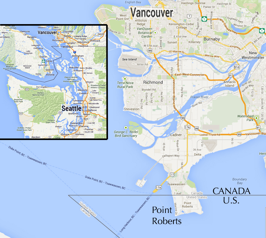
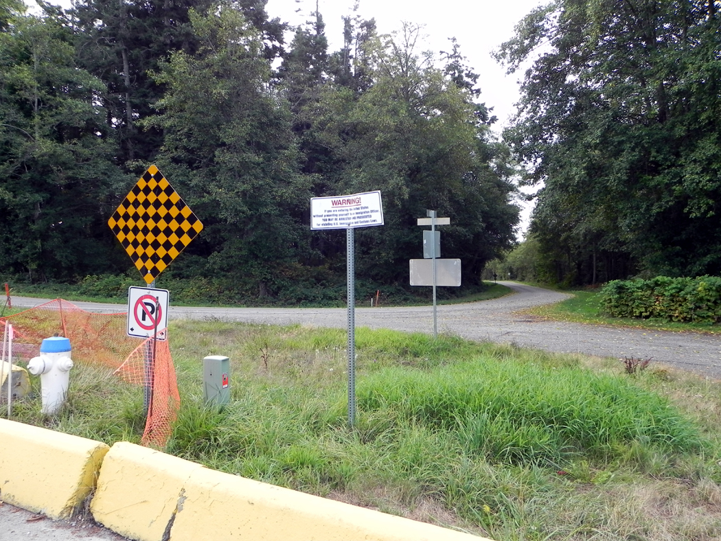
Now, Point Roberts might as well be an island. It is surrounded by water on three sides, with the Canadian border on the fourth. It is a 23-mile drive through British Columbia to get from Point Roberts to the rest of Washington.

It has made life interesting for the 950 people who live there.

For one thing, all electrical power and telephones have to be contracted from Canadian companies; yet when there is a repair problem, American companies are responsible.

And when a crime is committed — admittedly not a common occurrence — the miscreant must be helicoptered or boated back to the mainland; he cannot be squired by road through Canada and back into the United States.

The police blotter of Point Roberts is worth mentioning.

In the four months from August through November, as reported in the All Point Bulletin, the local newspaper, the majority of reports were of three types: drunkenness and drunken driving; trying to cross the border with marijuana; and burglar alarms that went off accidentally. Sometimes a power surge is blamed.

There are also a few nasty tales of domestic violence: A daughter got into a fight with her mother and ”knocked a bunch of books off some shelves,” and a girlfriend threw a brush at her boyfriend.

But amongst the reports are a few worth quoting whole.

”Sept. 20: An individual reported that Camp Ruth Morton had been broken into and three fire extinguishers were stolen and recovered on the property empty. Fingerprints were taken. Case under investigation.”

”Sept. 21: A park manager in the 1400 block of Gulf Road reported that after having a dispute with a tenant, the tenant exposed his buttocks to him and his young children. The manager wished the information to be documented and the tenant contacted. Tenant denied any wrongdoing.”

”Sept. 22: A 46-year-old Vancouver, B.C., man was arrested for assault in the fourth degree after police, who had been called to the residence in the 1500 block of Panorama Drive for a possible domestic dispute, witnessed the man jerking a female by the collar and would not allow her to get up. The man was escorted back to Canada.”

U.S.-Canadian border

U.S.-Canadian border

”Sept. 29: An individual in the 100 block of Monte Road reported that his next-door neighbor had plugged a travel trailer into his house without asking. The individual does not know how long it had been plugged in. A note was left for the neighbor who had said no note was found. A summons will be sent to the neighbor for theft in the third degree.”

”Oct. 1: An individual advised that around the first of August, an unknown subject entered the U.S. from Canada and requested political asylum. The subject was Canadian and did not meet any requirements. The subject ran back to Canada leaving a bicycle and has not returned.”

So, you see, life is not uneventful in Point Roberts, especially in late September.

Point Roberts was named in 1792 by Captain George Vancouver after his longtime friend Captain Henry Roberts. Point_Roberts guard sign

It was settled by Icelanders, who scraped out a living by fishing and farming, although the soil is some of the worst in Canada. Later, canneries opened up to process the haul of fish from traps set into shallow Boundary Bay. Point Roberts reached the apogee of its fame during Prohibition, when the community was a hotbed of rumrunning.

Tables turned after the repeal of the Volstead Act, when Canadians began to come to Point Roberts on Sundays to drink. At the time, it was illegal to serve alcohol on Sundays in Canada. A thriving saloon business began that survives to this day, with the addition of bingo, although the bars advertise it as ”gambling,” because bingo just doesn’t sound illicit enough.

Things begin hopping in Point Roberts in the summer, when vacationers from Vancouver swarm the place, quadrupling the population. A marina is the central attraction. boundary obelisk

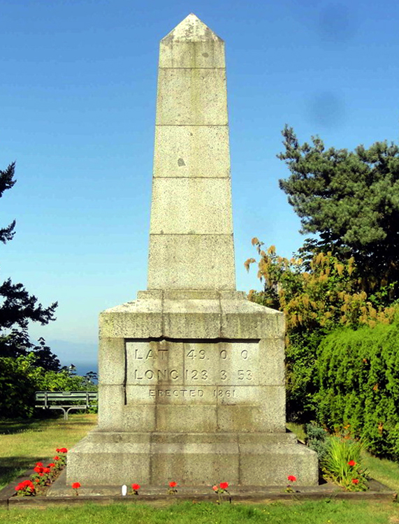
But hidden in the northwest corner of the enclave, along Roosevelt Way, is a monument of historical importance: the westernmost boundary marker along the 49th Parallel. It is a worn, lichen-crusted stone obelisk marking latitude 49 degrees north and longitude 123 degrees, 3 minutes and 53 seconds west. The surveyors who fixed the border started from this point and worked their way east.

Small customs offices are on both sides of the border on Tyee Drive. The Canadian office is newer and slightly larger. But the United States, not to be outdone, has built a new $5 million facility to replace the old one.

In the basement is a jail, needed to hold criminals until the boat can take them to the mainland.


This brings to an end the series of entries for “California and the West,” chronicling the drive from Tijuana, Mexico to Vancouver, Canada.

seattle aquarium rainy day

It is one of the unexpected symmetries of nature that the tropics should spawn the zillions of exotic flowers and vines that are its trademark, but that the abundance of ocean life grows where the water is cold. Puget Sound is cold year round.

A short list. Puget Sound has: 50 species of sponge; 200 species of annelids; 20 species of anemone; 70 species of shrimp; 25 species of hermit crab; 20 species of seastars; 36 species of sculpin; 24 species of rockfish; 16 species of limpet; and four species of octopus, including the world’s largest at up to 20 feet across and over 100 lbs., the Octopus dofleini.

And the animals of the Sound are often as exotic and lurid as any humid liana or dripping orchid.sea pen 2

There is, for instance, the Ptilosarcus gurneyi, or seapen. This has nothing to do with the spiny bivalve of the East Coast. It is not even a bivalve. It is an aquatic plume with its nib in an inkwell, buried in the sandy bottom of the Sound. It is bright orange with a fringed plumage that stretches up to a foot long. It is luminescent and produces a bright green light when stroked.

Seapens belong to the same general group of Cnidarians as the sea anemones, but the fact that their polyps are small and organized into a featherlike colony obscures that relationship somewhat.

What binds most of the invertebrates of the Sound together is color. The richness of the colors on the seabed shame the peacock. There are the three sea urchins each a different lascivious hue. Stongylocentrotus purpuratus is dayglo purple; S. droebackiensis is forest green; and S. franciscanus is 6 to 8 inches across and bright red and purple. It is a basketball among urchins.

The white sea cucumber is white as milkglass with electric orange thorns along its length. starfish pile

The starfish were manufactured by Binney and Smith. The Solaster stimsonii has 10 legs and each is striped with blue showing brightly against the field of ocher. The bloodstar is blood red; the rose star is pink; and Leptasterias hexactus has six legs and shows the color of a pomegranate.blood star

The sunflower star has up to 24 fat legs and is a dull yellow with bright orange rays.

The sea lemon is a 7-inch long nudibranch that is lemon yellow — a translucent yellow back with amorphous scores of lacy tubefeet. Puget Sound has more kinds of echinoderms than anywhere else in the world.

There are lavander abelones; 8-inch-long gumboot chitons; light blue filaments on algaed rocks that are an annelid, Thelepus crispus; crimson anemones; giant barnacles (Balanus nubilus) that are over 3 inches across; red-tissued scallops with rock colored shells and dozens of black eyes peering through the feathery antennae around the seems of the shell; gordian-knotted basket stars; warty, transparent, hairy sea squirts and sea pork; a red and pink anemone that is 12 to 15 inches across its waving tentacles.Green anemone

There is the edible pride of the Sound, the Panope generosa, or geoduck clam (pronounced as “gooey-duck.”) It is a bivalve that weighs up to 20 lbs. and, with its oversize siphon, looks like a bratwurst on a sliced kaiser roll. The meaty parts of the geoduck are so large that it cannot close its shell.geoduck

The other edible wonder is the sweet-meated Dungeness crab. Others may brag on their Alaskan king crab, but to those who have tasted the Dungeness, so much bragging on a thing merely because it is large is gauche, fit only for a Texan. The Dungeness makes the AKC seem like a can of tunafish.

So far, I have barely mentioned any fish. But they are as abundant and varied as the invertebrates. There are prickleback, gunnels, tubesnouts, pipefish, sea horses, sculpins, clingfish, and spiny lumpsuckers among the odder finny wonders.striped greenling

The painted greenling has zebra-stripes of cobalt blue on a salmon field with random purple and white spots. The Gobiesox, a clingfish, is round and fat with a flat head and a sucker on his bottom and is tan, netted with purple and with white spots or freckles. One tubesnout, Aulorhynchus flavidus, is translucent and yellow-green. It is 3 or 4 inches long, but narrow as a drinking straw and one can see his organs twitching on his insides.

By far the best place to see these zoological delights is the Seattle Aquarium. It is the best aquarium I have ever seen, making even the Coney Island show look bush league.

And the most wonderful feature of the Seattle Aquarium is the dome.Aquarium big room

Inside a huge tank of seawater, there is a many-windowed dome looking up and into the fish-filled water. The tank is decked out to look like the bottom of the Sound, one side complete with harbor pilings to gather barnacles, and the other strewn with rocks and sand. And swimming around are many of the aquadynamic shapes common to Puget Sound.

The sides of the tank scintillate with the wavering colors of sunlight broken up by the prisms of the waves on the tank surface. Through the spectrum swim trout, tomcod, salmon and catfish. The silvery salmon look like something manufactured by Boeing, like unpainted airplanes with scales for rivets. The glint of sun runs from nose to tail as the fish whips its body, propelling itself through the fluid.

The brown trout show an irridescent green when the sunlight hits.octopus 2

Huge scrotal octopods, all valves, siphons and tentacles, are strangely graceful.

A lime-white seastar rests on the sandand over it a flounder, like some Arabian magic carpet, flies, wavering its Persian body.

There are tomcod with supernumerary fins and charcoal gray dogfish with white-limned fins.

Looking sleepy among the rocks is a wolf eel with its prizefighter’s prognathous face. He is metallic blue with black coindots in bands across his body. He slithers around the floor boulders prehistorically.wolf eel 2

A sculpin stares straight at me from behind the glass with two Japanese fans for fins. A round, flattened seaperch floats slowly past the window. He has neon blue skin showing through rows of brown scales. Fom a distance he just looks brown, but up close, he is a vision.

Near me on one of the seats (church pews, I almost wrote) were four children, kicking their legs back and forth, ready to move on to whatever was next along the wall, and their shepherd, an older woman who must have been an aunt, asked almost of no one, but talking to the kids, “Isn’t it restful to watch them swim?”

But it is only restful to the adult, who has need of it. The children cannot yet understand the longing for such things.

coup de soleil, Puget Sound

coup de soleil, Puget Sound

Morning in Seattle and the drizzle slowly brightens in the dawn.

For those of us who wake up early, cities can be a problem. For although a city has a special attraction in the hours before traffic and business, it is also an oddly dead time. At 5 a.m., the light from an overcast sky slowly turns the glass on the empty bank buildings snow white; the downtown streets are vacant.Seattle roofs

And there’s really no place to find a good breakfast.

Sure, there are 24-hour chains like Denny’s, but I’m talking about a real breakfast. The fact is, a city is a slow riser. Like a groggy sleeper that first hits the snooze button, later spends a long time rubbing its eyes and finally stands under the shower half asleep, the city really takes all morning to get ready. Museums and the aquarium don’t open till 10. That’s five hours from now.

That’s one of the attractions of camping. No matter how early you get up in the wilderness, it’s open.

But there are secrets the urbanite knows. There are places he finds where he and his truck-driving buddies can get a plateful of scrambled eggs and a cup of coffee. The kind of place you don’t want to wander into and ask for Evian water or eggs Benedict.

Seattle is one of America’s great cities, or at least it was before all the Californians started moving there, before every streetcorner was anchored by a designer coffee stand.

It was a city that had a waterfront, with docks and boats. Most of the waterfront is now a tourist attraction, but the seafood companies and shipping wharfs can still be found, a little north of the aquarium and Ivar’s Acres of Clams.

In the early morning, before the tourists hit, the railroad switcher still shunts boxcars up and down a rain-shiny Alaskan Way and workers still pile fish into the backs of trucks.

There is an industrial clatter and clang along the road, under the viaduct, and steam mixes with exhaust in the mizzle.

And the city’s most beautiful breakfast can be had beginning at 5:20 a.m. on board the Kitsap.

MV Kitsap arriving in Seattle

MV Kitsap arriving in Seattle

One of the jewels of Seattle is the Washington State Ferry System and the huge, 2,000-car ferries across Puget Sound start operating each day at that hour. For a round-trip ticket of $7.70, you can board the Kitsap (or Walla-Walla, depending on which one starts the morning in the city) and take the one hour ride to Bremerton on the Kitsap Peninsula.

On board, there is a cafeteria line where you can get eggs and bacon, or a sticky bun and a cup of coffee to take to the table by the thick-painted window where you can watch Alki Point glide by as you leave Elliot Bay and enter the sound proper.

From the water, Seattle shows itself off as a seaport. You pass Harbor Island and its 10-story tall orange cargo derricks, you pass the waiting Japanese freighters anchored in the bay, and you see the working wharfs along the waterside.Seattle docks and cranes

The ferry rumbles through the water with its great diesel engines rattling the floors and windows. It churns a frothing wake through the water behind you and your coffee seems more leisurely. You get a chance to observe the weather as you eat and notice the deep slate color of the water and the patch of sunlight that breaks through near Vachon Island. Maybe the rain will break, you say to yourself.

If you’ve been here long enough, you know better.

The ferry curls around the southern end of Bainbridge Island and through the tight passages of salt water running between red cedar trees.Tacoma head on

When it docks in Bremerton, you can just stay put and wait to take the boat back to the city.

If the 2 1/2-hour round trip to Bremerton is too much time for you to spend, the ferry to Winslow costs the same and takes only 35 minutes each way. For that trip you ride the Tacoma or Wanatchee.

Either way, the trip is Seattle’s greatest bargain.

Seattle skyline, Elliott Bay

Coffeemania has abated slightly in Seattle.

There are still ”espresso” signs in drugstores and hardware stores and a local radio station advertised ”egg nog latte” at Christmas. But there used to be a Starbuck’s or a coffee wagon on every street corner. Now, they are on only every other street corner.

And the image Seattle projects through movies and Frasier of an upwardly mobile society surviving on caffeine is still at least partly true.

But there are other Seattles. There is Ballard, for instance.

Ballard is a section of town where the Norwegians live. The tourist brochure actually says, ”Velkommen til Ballard,” in ekte Norsk.

And although most of Seattle is notoriously hilly, Ballard is flat. It is looked down upon, literally and figuratively, by most of the more trendy portions of the city.

Ballard

Ballard

I remember living on Phinney Ridge, directly above Ballard, and looking down at night to see the whole city illuminated below me. ”Ah, Ballard, City of Lights,” I used to sigh.

The point being that Ballard was entirely too dull a place for anyone to actually live.

But although most of Seattle, at least in the media, is a white-collar town driven by Microsoft wonks and Boeing engineers, Ballard is uncompromisingly blue-collar. Along the Salmon Bay waterfront are working fishing boats. They pass under the steel-girder railroad drawbridge and through the Hiram M. Chittenden Locks that connect Salmon Bay with Puget Sound.

Hiram Chittenden Locks, Ballard

Hiram Chittenden Locks, Ballard

The main street, Market Street, is lined with stores where you can buy useful things, like tools and food, and the people who live there are soft-spoken and decidedly normal.

The locks are the main tourist attraction, with the salmon ladder where, in the proper season, you can watch coho and chinook salmon swim upstream to spawn. And in another season, you can see steelhead trout come back downstream and head out to sea.

May 17 celebration, Ballard

May 17 celebration, Ballard

The Nordic Heritage Museum is a large and somewhat dusty collection of Norwegiania. Some of it is genuinely cultural, much of it has more to do with the folkways of second- and third-generation immigrants whose knowledge of the ”Old Country” is confined to woodcarvings in the form of trolls and funny-looking cookies made at Christmas.

Ballard is also a good place to shop for Norwegian cooking implements.

But if Ballard sounds more neighborly than exciting, then Bell Town may be more to your taste. That is, if you wear black clothes, tattoos and have parts of your body pierced. Belltown sign with space needle

In the area around Bell Avenue, between Second and Fourth avenues, there is a kind of neo-Haight-Ashbury growing up.

In the Speakeasy Cafe, you can order a vegetarian sandwich and sit down at a computer and check your e-mail or do the Internet research you need for the article you are writing on the resurgence of Marxism in counterculture music.

On certain days of the week at the Speakeasy, there are poetry readings and live music by bands you have not yet heard of. Belltown street

Up the street is Sit & Spin, a combination cafe and laundromat. Its walls are plastered with handbills for local bands and revolutionary art lectures.

”The Cacophony Society,” reads one, ”is a randomly gathered network of free spirits united in the pursuit of experiences beyond the pale of mainstream society. We are the irreverent industrialists of mirth, gleeful unionists struggling for the liberation of daydreams and special interest groups of absurdity. You may already be a member.”

While your underwear is in the spin-dry cycle, you can wander up to the counter and ask for homemade five-bean vegetarian chili on brown rice with cheese — $2.10 per cup — or the hummus plate, with cucumbers and pita bread, for $4.10. bell street belltown seattle

The place is decorated eclectically. Coaxial cable is a unifying motif, alternating with loops of old clothes-dryer exhaust hoses. There are video games, jigsaw puzzles and a lot of young, sturdy women in black wearing Doc Martens. The men are in black, too, with the occasional plaid shirt and jeans. There is an ethnic mix, although Seattle is predominantly white. Tans are even hard to find up here where it rains all winter.

Olympic mountains precipice

Washington’s Olympic Mountains are wet. Their slopes are covered in rainforest, with broad ferns and tall redcedars with soggy, mossy bark. When it isn’t raining, it is drizzling and when it isn’t drizzling, the fog is so thick it soaks your clothes.

The western slopes of the mountains average 140 inches of rain per year; its highest point, Mount Olympus at 7,965 feet, receives the equivalent of 220 inches, most of it snow.

The Olympics are also steep. Everything in the Olympic National Park is vertical. Nearly every mountain is a towering cliff. Driving the 17-mile park road from Port Angeles to Hurricane Ridge, one side of the car views an uplift of rock only inches from the window while the other side looks out over cirques whose centers plummet thousands of feet straight down.

Mountain goats manage to dance up the sheer wall of rock as obliviously as dervishes.Deer at Hurricane Ridge Olympic NP

Hurricane Ridge is the place inside the park most accessible to the outer world, with a parking lot at the end of the road and a lodge and snack bar looking out over the Elwha Valley and the wall of peaks on the other side.

Even in June, the spring wildflowers are just beginning to poke through the snowbanks on Hurricane Ridge. Clouds blow over the mountaintop and sometimes in the middle of a white out, when you are inside a cloud and cannot see what your feet are stepping on, you are treated to the peculiar vision of a hole in the scud, a circular opening that will drift past through which you can see 15 miles to the sunlit peaks across the valley.Hurricane Ridge, Olympic NP, Wash

But my favorite spot in the Olympics is not Hurricane Ridge with its car exhaust and souvenirs, but the trail to Lake Angeles.

Beginning at Heart O’ the Hills, it climbs 2,379 feet in 3.7 miles, or an average loft of about one foot for every eight feet. That is a grade steeper than any freight train can manage.

And the first time I made that hike, I went with a friend who was a bicycle messenger in Seattle, with a stainless steel cardiovascular system. I made the first two or two and a half miles just fine, but the fatigue began to do me in, while my companion might as well have been riding an escalator.

I continued, walking ever more slowly and thinking of Sir Edmund Hillary making those last steps up Everest at a snail’s pace, stopping to breathe after each choppy step.Near Lake Angeles, Olympic NP, Wash

As the altitude changed, so did the weather. What was a pleasant 55 June degrees at the trailhead became sleety as we moved from the Hudsonian biozone, out of the Douglas fir and into the subalpine zone with its spruce and cedar.

When at last the path flattened out and we turned out of the last cove and over the last ridge, we saw Lake Angeles. We had climbed from 1,879 feet to the lake at 4,196 feet and still above us, at the opposite side of the lake, were the triple peaks of Mt. Angeles rising to 6,454 feet.lake angeles

A sheer rock wall, partially obscured by mist, rose straight up to the jagged tops of the peak, like something from a Bierstadt painting.

In the middle of the lake was an island covered with Caspar David Friedrich trees and the colors of the whole scene were Thomas Moran’s.

I was standing in the mizzle, my glasses blotted out with droplets and my clothes too wet to wipe them clear.

Across the face of the cliffs beyond the lake was a line of falling water like a John Martin lightning bolt zagging its way 400 feet down the rocks and silently roaring at its half mile distance into the gray waters of the lake.

“We shouldn’t look at angels too long,” I said and we turned to descend.

a portland collage

What makes a city urban?

Those who live in the Western half of the country have to wonder sometimes. For Phoenix or Los Angeles — and most trans-Mississippi cities — are fundamentally different from the core cities of the East. The Western-model cities are sprawling suburbs, spread like a great tablecloth over the landscape.

It isn’t that they don’t have character. LA has enough character for a dozen smaller cities. And even Phoenix has its personality, although it is that of a raw, unformed, undisciplined adolescent.

But for anyone who grew up near New York, Philadelphia or Boston, there is something urgently missing out here that prevents the West from becoming authentically urban.

Purists may argue that any concentration of population must be considered urban. And they are technically correct. But walk the Loop in Chicago or by the row houses of Baltimore and you instantly sense the difference.

It is true that there are small bits of citiness in the West — a neighborhood in Denver, sections of Seattle or San Francisco. But these are fragments.

There is one place that has undiluted citiness in concentration.

On the banks of the Willamette River in Oregon is a true city. Portland has a downtown that could be a relocated Pittsburgh, bridges and all, and walking through its sinewed city center is a glory of chattering urban detail, all screaming out that this is a real city.

For it is the details that define the urban.

a portland strip 5

Portland is filled with the tiled floors, fireplugs, storm drains, eroded curbsides, overarching trees, root-buckled sidewalks and brownstone stoops that make a city feel urban.

It is all the more significant because the Portland downtown is so tiny. You can walk almost anywhere you need to go.

Yet in those 100 miniature city blocks — less than a square mile — you can discover all the urban detail, ornament and design that you need to serve as a madeleine to your Proustian nostalgia for a citiness.

Along the sidewalk, a checkerboard of frosted glass squares underfoot illuminates an old basement.

a portland strip

A brass fire-hose connection splits like a Brancusi torso.

A dull iron streetcar track in the cobblestones is wheel-shined.

An Art Deco 317 glows above the glass doors of the Loyalty Building.

The city is built of hard, durable metals and stone, yet all its edges are softened and weathered.

There is the steep ramp of the old brick parking garage. a portland strip 2

The spear points topping the black iron fences.

The revolving clock-thermometer at the corner of the bank building.

The equestrian statue in the middle of the park, with its benches and chess players.

”Joy The Tailor” is written in mosaic on the sidewalk in front of an empty storefront. Who knows how many businesses have operated in that building since Joy left?

There is the neon ”pizza” sign in the window, a neon ”Western Union” and a neon ”color copies.” a portland strip 4 copy

In front of a blockwide pit being dug out by the steam shovel, men on their lunch hours gather in a crowd behind a fence to stand and stare. One of them is eating a Fig Newton.

The one thing all those details speak of is age. The rounded edges of the curbs, the worn writing on the manhole covers — these things come with maturity.

The younger cities of the West — or the cities such as LA that seek eternal adolescence — cannot achieve the respectable age of the Eastern cities. It is a miracle that Portland survives.

For in LA, as in Phoenix, any building older than our high-school years tends to be flattened and replaced with one of those brittle, obdurate, unweathered and machine-edged monoliths, too juvenile to know better, too inexperienced to have the wisdom time brings to sandstone and concrete.

In a real city, you see the scoops of accumulated footfalls on the marble museum steps, you see ailanthus trees growing in the unattended spaces between buildings and moss on the gutters.

A real city is a stage set for our lives. We eat at the lunch counters, recline in the grassy parks, live when we are young or very old in the plastered apartments above the storefronts, drink grappa at night in the jazz bars.

The urban city is a setting not only physically but also historically. Its worn details, visible at every turn, remind us that we live in history, too. The city was there before us and will be after us.

In a city of strident newness, such as Phoenix, we can forget the big picture and think we are all that matters. In a city full of its own past, you are always reminded of your grandparents and grandchildren.

And it is all in the details.

columbia river gorge panorama

Imagine another Yosemite Valley, only 10 times larger and with a great river running through it, with twice the flow of the Nile.

The Columbia River Gorge, between Oregon and Washington, is just such a place. And if it had not been settled and its river used for commerce from its earliest discovery, it would have been a cinch to be made a national park.

Even so, it is still a National Scenic Area and runs 80 miles from near rain forest in the west to near desert in the east. It is a scenic prodigy.

Mt. Hood

Mt. Hood


You can see its immensity best perhaps from the air. Flying up the Willamette Valley into Portland, Ore., the Cascade Mountains stretch out to the east like a great rumpled bedspread, green with trees. Above the range are the white, snowcapped cones of the huge volcanoes — the Three Sisters, Mount Jefferson and Mount Hood, piled Ossa-on-Pelion above the greener peaks below.

As the plane turns west to land, you can see the Cascades continue north to Canada, and the white pyramids piled on top include Mount Adams, Mount St. Helens and, way out on the horizon, the biggest of all, Mount Rainier.

But gouged out of the mountains, running east and west in the space between Hood and Adams, the gorge looks like a giant slice taken from the middle of a continental meatloaf.

From the air, you can get some sense of the proportions of the gorge. It becomes easier to understand the geological processes that formed it, from the greenish Ohanapecosh Formation of mostly metamorphic rocks, some 40 million years old, to the many basalt flows and volcanoes that poured through the mountain valleys.

Most astonishing might be the great floods that tore through the gorge during the Ice Age, some 15,000 years ago.

Melting water had backed up across Idaho and Montana behind a dam of ice half a mile high. When the dam broke, 500 cubic miles of water — a fifth the volume of Lake Michigan — churned across eastern Washington and through the narrow gorge. Water left its mark 1,000 feet above the present-day city of The Dalles.

The Dalles

The Dalles

It is hard to comprehend the strength of the water. Nearly 10 cubic miles of water poured through the valley every hour for more than 40 hours — 10 times the flow of all the rivers in the world combined. It washed eastern Washington bare, leaving behind the area we now call the Channeled Scablands, still largely naked rock.

The Scablands

The Scablands

The ice dams reformed and rebroke as many as 100 times. Geologists believe the floods occurred on average about every 55 years for 2,000 years, widening and reshaping the Columbia River Gorge into its current U-shape.

Indians lived along the river as long ago as 10,000 years. Europeans first sailed up it shortly after the American Revolution and an American named the river after his ship, Columbia Rediviva, in 1792.

But it was the Lewis and Clark Expedition that literally put the river on the map.

The expedition followed the river to the coast in 1805 and camped there over winter, looking for a clear Northwest Passage from the East Coast to the West Coast.

By 1840, the Oregon Trail brought hordes of immigrants to the area, looking to farm and build new cities.

They came down the river, by road where possible, but across the watery rapids in the tighter sections where no roadbed was possible.

Nowadays, Interstate 84 follows the river’s south shore, or Oregon side, but it wasn’t until 1913 that anyone tried to find a way to build a continuous road through the gorge. scenic highway

That road, the Columbia River Gorge Scenic Highway, has been superseded and largely obliterated by the interstate, but sections of it are still driveable — 22 miles from Troutdale to Dodson and nine miles from Mosier to Rowena.

You can get the big picture from the air, but to really know the beauty of the gorge, you need to be on more intimate terms, and the remnants of the old highway — now called the Historic Columbia River Highway — are the best way to do that.

Beginning in Troutdale, you drive across the Sandy River toward Springdale. The road stays on the back side of the ridge, so you cannot see the river until you get to Portland Women’s Forum State Park, where a small parking lot affords a grand view up the gorge. You are on a bluff some 700 feet above the water, and the mountains pale into powdery blue as they recede. In the rake of morning light, it looks like a Chinese ink painting.

A mile or so down the road, the next outlook comes at Crown Point and the historic Vista House built in 1916. The octagonal building serves as a visitor center for the gorge and has exhibits and a very good gift shop.

View from Crown Point

View from Crown Point

It also has views for 30 miles in each direction.

The highway climbs down the river side of the ridge and begins to follow the water and the interstate. Nevertheless, this section from Latourell Falls to Horsetail Falls is the highlight of the trip.

The river is lined with a thousand-foot cliff, some 10 miles long, over which cascade more waterfalls per mile than any place in the world outside Hawaii.

They jump off the top of the cliff and pour, almost in slow, misty motion, to the pool below. With names like Mist Falls, Bridal Veil Falls and Punch Bowl Falls, they give you a sense of almost tropical richness.

Multnomah Falls

Multnomah Falls

Indeed, just above the most famous of them, Multnomah Falls — with its parking lot and lodge — sits Larch Mountain, where the annual rainfall is 200 inches.

Another 50 miles down the gorge, at The Dalles, the rainfall drops to 12 inches a year.

The best view of the dry, eastern end of the gorge is from Rowena Crest, where an overlook sits like an aerie over the dry basalt hills near The Dalles. Grass is yellow in the summer, and you sometimes can look out over the shoulders of hawks.

The eastern end of the gorge also can be quite hot. In July, the temperatures easily can top 110.

If you continue east on Interstate 84, past the Deschutes River, you can cross the Columbia on the Sam Hill Memorial Bridge at Biggs.

Once across and in Washington, there are two other Sam Hill monuments you should see.

Hill was the Washington mover and shaker who managed to get the early highway built. He also constructed a mansion for himself out in the blasted rocky grasslands. He called it Maryhill, and it is now an art museum with a respectable collection of work, specializing in Russian icons, art chess sets and the sculpture of Rodin.

But the oddest Hill monument is the concrete Stonehenge he built in 1918 as a memorial for the war dead of Washington’s Klickitat County. The imitation Stonehenge was meant to look like the original did when new, so it has a strangely antiseptic look, without the patina that age gives history. Maryhill stonehenge WWI monument

Coming back through the gorge on the north shore along Washington 14 — known as the Lewis and Clark Highway — you retrace your route with a whole different look. The desert gives way to the trees, and the smaller road twists around headlands and coves.

At Stevenson, Wash., the Columbia Gorge Interpretive Center has exhibits not only on the geography of the area but also its history and culture.

And near North Bonneville, the great Bonneville Dam blocks the river flow in five disjointed segments between four islands. It was one of the great public works projects of the Great Depression and opened in 1938.

Bonneville Dam

Bonneville Dam

There are modern visitor centers accessible from each shore.

The Bradford Island Visitor Center, reached from the Oregon side, is the larger, but the Washington Shore Visitor Center has the better view of the powerhouses with their huge generators.

Further along, Beacon Rock stands like a giant upended football, 848 feet high, with a hairpin stairway up its side for adventurous climbers. It was named by Lewis and Clark and marks the beginning of Columbia River tidewater.

Beacon Rock

Beacon Rock

The final monumental attraction of the trip is the skirting of Mount Pleasant and the section called Cape Horn, where the road barely holds onto the rock wall. Several turnouts offer a final glorious view of the gorge.

All along the way, there are state parks and nature preserves. Wildflowers are startling, hiking is popular and so is bicycling.

And above everything, you get the occasional unblocked view of white-headed Mount Hood, a beautiful, symmetrical volcano that is the symbol of the area.

fort clatsop brochure

Most people visit Fort Clatsop in the summer and so miss understanding history. The only proper way to see it is in midwinter, when the air is as raw as frozen hamburger and the rain drizzles down into the fibers of your clothing.

Fort Clatsop National Memorial is just a few miles from Astoria, Ore., and is where the Lewis and Clark expedition spent four cold months in 1805-06, waiting for the spring thaw so they could return to civilization. Meriwether Lewis and George Clark had led an expedition of 45 men up the Missouri River beginning in 1804, exploring the Louisiana Territory that President Thomas Jefferson had just bought from France. Lewis and Clark were charged with finding a way through the territory to the Pacific Ocean on the other side of the continent.

They spent two summers and a winter getting to the Pacific and another winter camped at Fort Clatsop, which they built as temporary quarters and a way to keep some of the constant rain off their heads. Of the 106 days they spent at the fort, the sun shone for six. fort clatsop fog

Life was constant misery. According to their journal entry for the day after Christmas, 1805, ”rained and blew hard last night, some hard Thunder. The rain continued as usial all day and wind blew hard from the S.E. Joseph Fields finish a Table & 2 seats for us. we dry our wet articles and have the blankets fleed, The flees are so troublesom that I have slept but little for 2 night past and we have regularly to kill them out of our blankets every day for several past. maney of the men have ther Powder wet by the horns being repeatedly wet, hut smokes verry bad.

Lewis and Clark were not hired for their spelling.

The original fort is long since returned to the soil it came out of. But a copy of the original, built from the description and plans in the expedition journals, has arisen in the original location.

The fleas have not been re-created for the modern visitor.

It is a very small fort by the standards of anyone who has seen palisaded forts in John Wayne Westerns. It is exactly 50-feet square and divided into eight rooms, three on one side and five on the other, with an open plaza between them. This was technically called the ”parade ground,” but no parade longer than a pace and a half would be possible in its Lilliputian length. Fort Clatsop interior

The largest room went to Lewis and Clark. The three smaller rooms on one side were given over to the remaining crew, up to 15 per room. And the smallest quarters, next to the commanders’, was given to the French trapper Touissant Charboneau and his Indian wife, Sacagawea, and their infant baby. The remaining small rooms were a meeting room and a supply closet. sacagawea dollar

In December, when you should visit the fort, fires crackle in the hearths of the rooms and volunteers give demonstrations of some of the things the explorers had to do.

A class of visiting high-school students was divided into a group that used rod and chain to learn primitive surveying and mapping techniques; another group that attempted to write with quill pens; a third group that made candles out of tallow; a fourth group that learned how to blow a glowing flint-and-steel spark into a flame; and a fifth group that heard about animal furs.

The smell of wood smoke penetrated everything. Hours later, I still could smell it in my coat. The smoke hung low above the log-cabin fort, which is a sign that canny weather watchers can use to predict rain. As if the prediction were necessary for an Oregon winter.

In 1805-06, the men came down with influenza and other sicknesses brought on by exposure. They managed to kill and eat 131 elk and 20 deer.

Lewis and Clark had to leave the fort earlier than planned when the early spring thaw drove the elk up into the surrounding mountains and left the men without a dependable menu. fort clatsop postcard

”We have not fared sumptuously this winter and spring,” they wrote in the journal as they prepared to break camp.

And when they reversed their route, they returned to St. Louis in half the time it took them to go out.

USACE Tillamook Bay Oregon

Tillamook has a more interesting history than most towns of its size and obscurity.

While most towns north or south of it on the Oregon coast have catered to the vacationer, with beachfront motels and seafood restaurants, Tillamook remains a working town.

And although it is situated along U.S. 101, which is the famous Coast Highway, Tillamook is back from the ocean, in a wide flat valley filled with cows and lumber.

There are also a series of prominent mud flats.

But the predominant impression is of green: vast pastures filled with cows. Tillamook is primarily a dairy town, with several cheese factories.

There is a short-line railroad with a diesel locomotive painted in the black-and-white patchwork of a Holstein cow. Tillamook Cheese Factory

Self-guided tours of the Tillamook Cheese factory are available, with samples of curd and Cheddar. The factory produces 40 million pounds of cheese each year. You can watch it being made in 40-pound cubes and then cut by automated cheese slicers into smaller familiar sizes. An small army of snood-headed women watches over the assembly line to keep track of errant chunks of cheese and misshapen cubes.

I briefly considered buying a whole 40-pound block but changed my mind when I discovered it would cost about $120.

The high school football team is known as “The Fighting Cheesemakers.”

Tillamook was also the site of the worst natural disaster in Oregon history, in 1933 with the first of a series of devastating forest fires known as the ”Tillamook Burn.”

The fire had a 15-mile front and in only two days destroyed 255,000 acres. And the fire raged for four weeks.

Fires recurred every six years until 1951, causing them to be named the ”six-year jinx.” Ultimately, 325 square miles were burned. It cost $13 million to reforest the blasted areas, which now look green and woodsy.

Natural devastation also did in the vast land speculation known as Bayocean. Beginning in 1906, a series of investors cooked up a scheme to turn a sand spit at the mouth of Tillamook Bay into a vacation paradise, with cottages, hotels and a gigantic natatorium with heated water.

Bayocean natatorium and dance hall

Bayocean natatorium and dance hall

Lots were sold, buildings were built and sales were slow, in part because there was no way to get to the development. There were neither roads nor trains, and the yacht that was supposed to carry passengers across the bay was too large to pass over the mud bars.

But more devastating was the fact that the builders hadn’t taken into account the nature of spits: They grow and shrink with the waves, and it wasn’t long before Bayocean’s cottages fell into the aggressive surf. There was a brief period of prosperity in the community during the ’20s, but by 1932 the natatorium collapsed into the sea. In 1952, a storm split the spit into three smaller islands. The last vestiges of construction on the spit were wiped out in 1960. Today, it is just a story they tell in town.

Bayocean hotel view

Bayocean hotel view

I doubt many in Tillamook still sing the popular song from 1925, Tillie From Tillamook: ”Tillamook Tillie got wild one day, packed up her things and went away. She got weary of the birds and the bees and living on Tillamook cheese.”

According to the song, she moved to Manhattan and the chorus sings out: ”Wooden shoes, a hole in her sock, knees that knock-knock, knock-knock. She’s lopsided and she got that way getting up at break of day. Tillie, Tillie, Tillie, sweeter than the new mown hay. She’s the crash of Broadway today!”

Another piece of Tillamookana, however, is still there to see, just south of town: the world’s largest wooden building. It is a blimp hangar built during World War II for the Navy. There used to be two of them, but one burned down in 1992 when its contents, $300,000 worth of straw, caught fire. The conflagration was so intense that the fire drew 80 mph winds into the hangar.

Hangar B

Hangar B

The remaining hangar for now contains the Tillamook Air Museum, with a handful of World War II-era planes, a couple of blimps and some helicopters, along with interpretive exhibits that tell the story of the hangars and the blimps that were used during the war to patrol the Pacific looking for Japanese submarines.

The building is 1,080 feet long, 300 feet wide and 195 feet high and covers 7 acres. You can’t miss it as you drive along 101. There are geological features listed on maps that are smaller than this great humpbacked mega quonset hut.

Yaquina Bay Bridge

Yaquina Bay Bridge

Forget the bridges of Madison County, the bridges worth writing about are on the Oregon coast.

As the coastline meanders in and out along the Pacific, the roadmakers were faced with two problems: how to climb the rocky headlands and how to bridge the broad, flat river estuaries. They took care of the headlands with dynamite and pick, but the rivers were something else.

First, they were unusually broad, combining, as they do, elements of river, estuary and tidal mud flat. The soft ground didn’t make it easy to anchor a bridge. Second, the usual material for building bridges in the early part of this century was iron, which tended to rust out very quickly in the salt-spray air of the coast.

Wilson River Bridge

Wilson River Bridge

Consequently, most rivers were crossed only by ferry, even after the Pacific Coast Highway was dedicated in 1923. It wasn’t until federal matching funds were made available for highway construction, and later the Works Progress Administration kicked in, that the final T’s were crossed and the last bridges were installed.

Now, bridges ordinarily don’t get me excited. I like a good bridge as much as the next guy, but I can’t claim to be a fanatic. conde mccullough

But the bridges that cross the Oregon coast are different. They are some of the most beautiful bridges ever built. And the credit goes to one exceptional man: Conde McCullough, a South Dakota-born engineer who presided over the Oregon Highway Department as bridge engineer during those critical years.

His designs are admired both for their engineering skill — he was an innovative engineer and used many new techniques, including prestressed concrete, for the first time, or very nearly so — and for their aesthetic grace.

I cannot speak with any authority on their technical aspects, but I can say that, taken as a whole, they are the most beautiful set of highway bridges I’ve ever seen.

McCullough had a few recognizable habits. He used a good deal of Art Deco ornament on the bridges. Many have decorated pylons at the entrance to the bridge. Others have abstract floral scrollwork carved into their girders.

And these certainly make the bridges distinctive.

But it isn’t the ornament that makes them so satisfying to look at; rather it is the incredible sense of proportion and rhythmic movement McCullough managed to enshrine in his steel and concrete sculptures.

Anyone who has taken notice of the mint-green steel arches between molded concrete abutments that cross the river mouths on the Oregon coast will be able to recognize McCullough’s handiwork whenever else he sees it.

Coos Bay Bridge

Coos Bay Bridge

The bridge over Coos Bay, for instance, which now is named the McCullough Memorial Bridge, is a series of long arches like the path of a bouncing ball. Over them the roadway passes, rising slightly and connected to the arches underneath with a series of vertical beams, just the same graceful thickness as the arches themselves.

Coos Bay Bridge girders

Coos Bay Bridge girders

And across the main span, an equally graceful series of steel girders crosses the roadway in a series of gothic arches, crossing themselves in a way reminiscent of the great crossed arches of Exeter Cathedral in England.

As you drive across, you can’t help but have the feeling that you are driving down some great dignified nave.

His bridge over the Rogue River is a counterpoint of tall, Roman-aqueduct-style arches against the longer bouncing-ball arches of the spans themselves. Built in 1931, it was the first structure in America to be constructed with the Freyssinet method of pre-stressing concrete and has been designated as a National Historic Civil Engineering Landmark by the American Society of Civil Engineers.

Cape Creek Bridge

Cape Creek Bridge

Three different types of arch work together in the Cape Creek Bridge at Devil’s Elbow State Park, and in the Yaquina Bay Bridge at Newport, the 3,223-foot structure is a graceful ascending line of highway supported by long, flowing arches, with a center-span arch that leaps high above the roadway. The center span is further set off by the concrete ”finials” that top off the support span.

Yaquina Bay Bridge

Yaquina Bay Bridge

A lot of money has been spent on public art, but very little is of such lasting significance as these civil projects created by an engineer who was also an artist. When McCullough died in 1946, he left a more lasting and distinct personal signature on the state than any political or social leader.