Archive

Tag Archives: hiking

It has been 50 years since I was a Yankee student at Guilford College in Greensboro, N.C. The day I arrived, as a tender freshman, a 20-foot banner hung from the front of my dorm that said, “Forget? — Hell!” I had never been any farther south than Washington DC. I didn’t know what that meant until someone told me. The South has a long memory — at least for a grudge. 

I have since come to love the American South, and have lived in it longer than I have lived in any other region of the country. I don’t share its politics, but I was at a Quaker college and its values were those I shared. I studied hard — not really true: I took lots of courses and wanted to learn everything, but I can’t say with any honesty that I was a hardworking student. I read constantly, but not always those things required for my courses. 

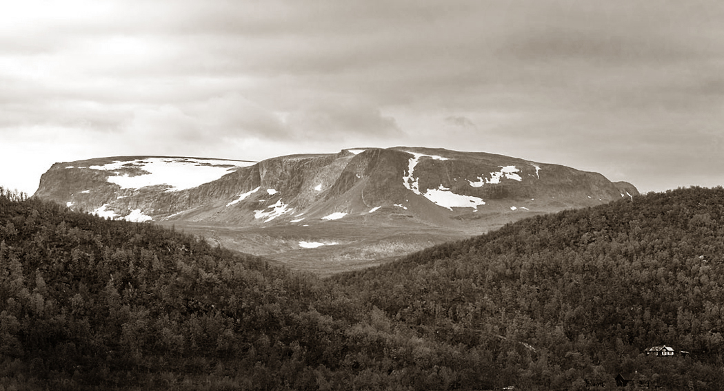
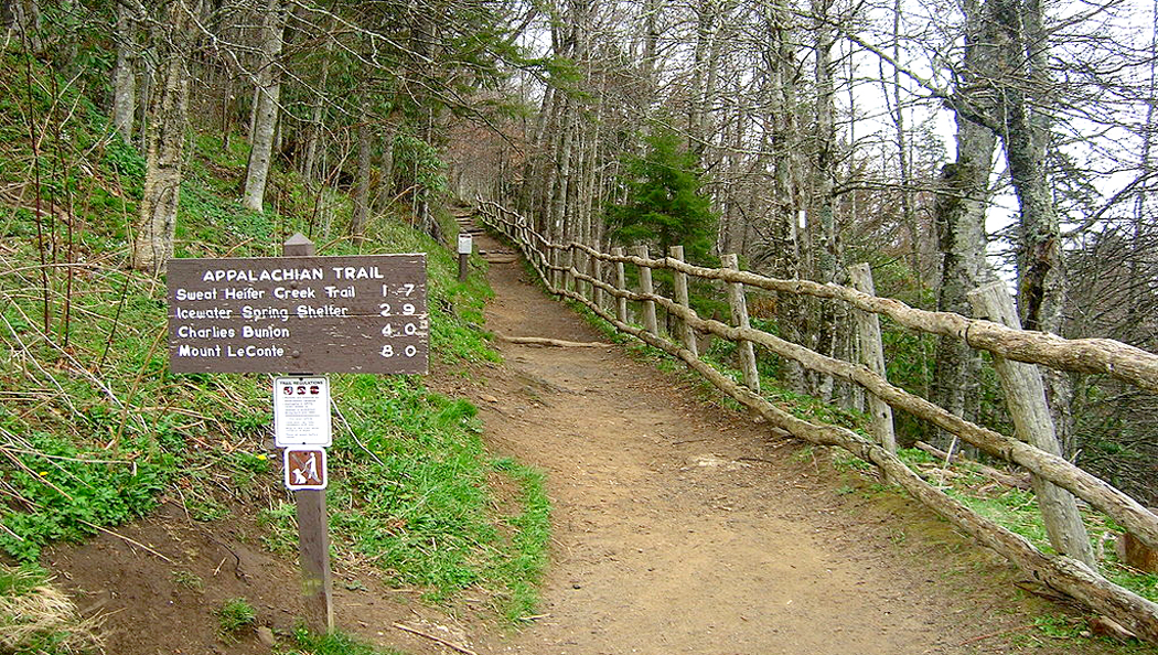
One day, another student, Big Jim McLarty, said, “I’m going hiking in the Smokies next week. Wanna come?” The Great Smoky Mountains National Park strides the boundary between North Carolina and Tennessee with some of the highest peaks east of the Rockies. The Appalachian Trail balances on the top of its ridges. Big Jim wanted to hike the central portion of the range, to Ice Water Springs. 

Big Jim was the son of a noted Methodist minister from Asheville, and the baby brother of the actress whose stage name was Eileen Fulton. (Birth name: Margaret Elizabeth McLarty). For 50 years, she was a fixture on the soap opera, As the World Turns, where she played Lisa Miller Hughes Eldridge Shea Colman McColl Mitchell Grimaldi Chedwyn, wife of six husbands, divorced three times, widowed four times, participant in more than 30 love affairs and victim of amnesia, kidnapping, hysterical pregnancy and auto accidents.

Big Jim had a “stage name,” too. He was the Nunny (more properly, The Noney.) When he first came to Guilford, he had to fill out a form with personal information and in the box for “church preference,” he wrote: “None.” It caused a kerfuffle at the time (We’re talking the late ’60s in the South, where there is a church on every other street corner) and he became known for his freethinking answer. (I came a few years later, and when I had to answer the same question — church preference — I put down: “Gothic.”)

Anyway, The Noney said just to pack sleeping bags. He would bring the food for the trip. “I have lots of stuff left over from earlier camping trips,” he said. 

And so, we drove up U.S. 421, U.S. 64 and U.S. 70 to Asheville, where we stopped at The Noney’s ancestral home to pick up his gear and then drove down past Maggie Valley and Lake Junaluska to the Smokies. The sunny day turned cloudy and The Noney explained that the mountains sometimes make their own weather. This was a new concept to me and I was suitably amazed. Nothing like that happened in New Jersey, where I grew up. The turnpike never made its own weather, although perhaps the Monsanto plant did. 

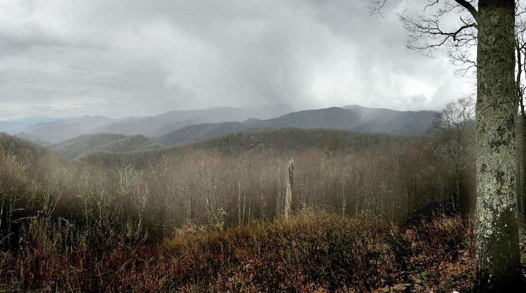
We parked in Newfound Gap and began the hike about three miles north on the Appalachian Trail and stopped for the night at a lean-to at Ice Water Springs. 

The woods were thick around us, but you could see parts of Tennessee to the west. There was a wooden lean-to in a clearing. It had eight bunks along its back wall, in double decker, and with a chain link fence across its front. 

“Are there bears?” I asked, with some thought to my own safety. We didn’t have any bears in New Jersey. My only experience with a real bear had been at the Bronx Zoo. Other than that, there was Yogi Bear on TV and when I was an infant, a giant stuffed panda bear. But there were actual bears in these woods. 

“Don’t worry,” said The Noney. “You just treat ’em like a big dumb dog.” This pretty well capsulized The Noney’s approach to life in general. He was one of those sparkly people that nothing bad ever touches — or who remain unaware that bad things are even a possibility. 

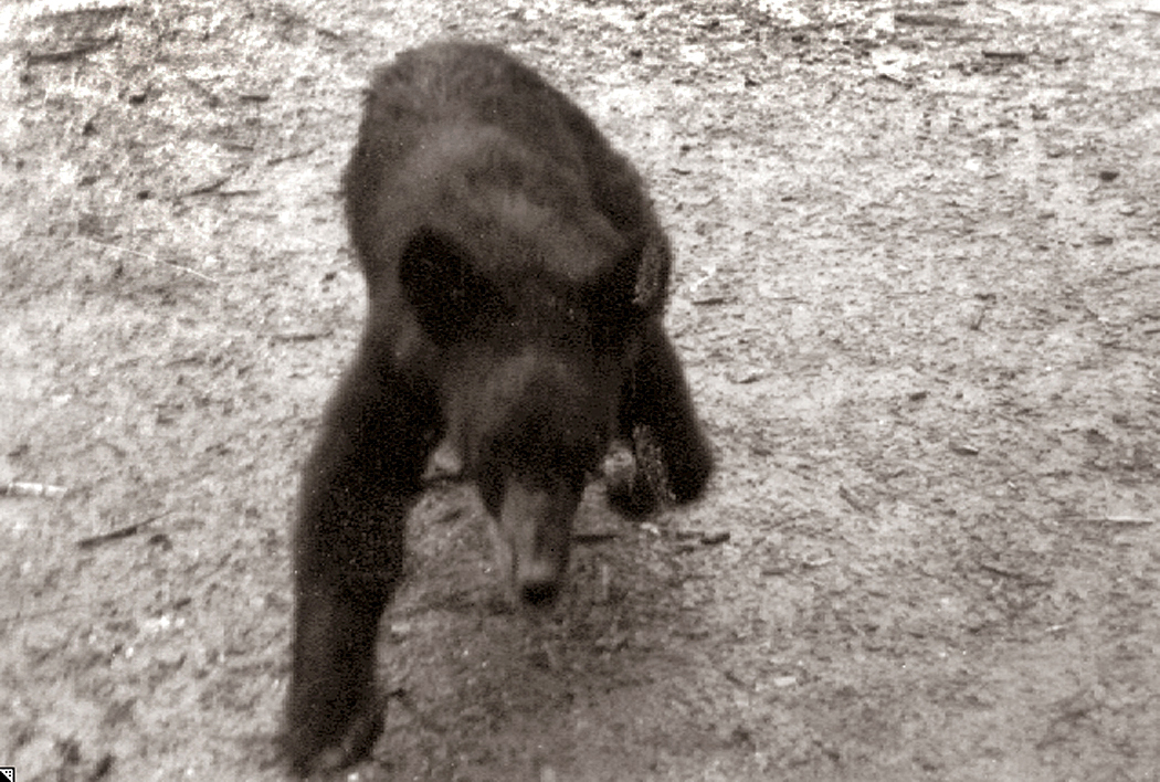
It remained overcast and by late afternoon, I was standing just outside the lean-to making photographs, when a bear crossed the path about 30 feet away. It spotted me, hesitated a moment and then charged. It lumbered (as bears do) straight at me and got to within a few feet of me before turning away and running off into the woods. Big Dumb Dog. Big Dumb Me — I stood there and took a photo of the bear charging. Maybe it wasn’t the biggest bear in the woods, but it was big enough. And I snapped the shutter instead of ducking.

Come dinner time and the dusk, and The Noney scrounged around in his knapsack and pulled out a handful of tinfoil bags, looking for a dehydrated dinner. But there was nothing but dehydrated strawberry milkshakes. “I guess I must have already used up all my dinners,” he said. We were hungry after a day’s hiking and bruin-dodging, but the cupboards were bare. Lucky for us, some other campers in the lean-to were generous and offered us some of their food. The Noney just laughed it off. 

And so, in the middle of the night, sleeping behind the wire-mesh fencing that protected the lean-to inhabitants from the creatures of the woods (although not from the mice), a noise woke me up. The knapsacks hanging on the wall were rocking back and forth, the fencing was jangling. A bear — rather larger than the one I photographed — was attempting to steal our bindle, reaching between the fencing and the wall, stretching out its paw to get the goodies. It was pitch dark. I didn’t know what to do.

Then The Noney flew from his sleeping bag as if he were shot from a cannon, and screaming at the top of his lungs with his arms flailing, running toward the bear. The bear was stopped short and the half-dozen campers in the other bunks were jerked awake not knowing what all the noise was about. The Noney screamed and flailed; the bear withdrew judiciously and everyone else’s flashlights turned on. The Noney stood in the spotlight and smiled. “Big dumb dog.” 

carnac-alignment

We went to see the stones. They stretched for miles, each stone like an  upright soldier in a formation. They are called “menhirs,” and they populate the area around the seaside town of Carnac in Brittany.

When we drove up to the first formation, the sun was low in the sky and shadows stretching long. We stopped by a field filled with menhir and dolmen, the ancient stones erected some 7,000 years ago for god knows what purpose. Thousands of the stones in stripes across fields, and made of a type of granite that is not local. No one knows how they were made nor why. Carole was especially worried about why.

“Maybe they were religious,” she said. That is the most common supposition. But that didn’t really satisfy her.

“I know,” she said, “they must have been used for some sport. If something was important enough for men to exert this much communal effort to transport tons of stones over miles and miles, there must be a stick and a ball involved.”

We’d drive for a few more miles and she’d pop out with, “Or maybe they were the foundation for some kind of building,” and then, after not saying anything for a long while, “Maybe they were meant to line up like soldiers; maybe they scared off an enemy.” She seemed obsessed with the stones.

tourists-at-the-menhir

Click on any photo to enlarge


The next day, we went out to explore. Some 4,000 menhirs, or upright granite stones, from about three feet high to almost 20 feet, are striped across the landscape in three or four major “alignments,” as they are called.

Erected some 5 thousand years ago, or maybe 7 thousand — it all seems lost in the haze of prehistory — the Celtic forebears of the Bretons hauled these logs of granite from their origin, miles away, and lined them up over the rolling meadows just north of town.

No one knows that they were erected for. The usual theories of religious meaning are trotted out, but no one really knows. Carole persists for a while that they must have been used for some sort of sport or game, going on the theory that only a Superbowl or the Olympics can bring that much commitment out of a guy, let alone a lot of guys.

menhir-3

We talked about it at lunch, in Locmariaquer, the site of some other megaliths.

Over the oysters, I said, “I think that it is just as likely that someone in the old days went crazy, heard voices in his head telling him to to this, and he then, through the intensity of his insanity, persuaded the community to erect the menhirs. Like a sachem in an Indian tribe. ”

Carole dislike the idea that this might reflect badly on shamans. She maintains there is a difference between visions and psychosis. She has her own reasons for holding this distinction.

“That’s not quite what I mean,” I said. “I mean that someone genuinely nutso hears voices, like Son of Sam — ‘My dog told me to do it’ — and because to ordinary people a shaman and a nutjob are very hard to tell apart, they might have signed on to follow him, the way the Germans signed on to follow Hitler to Valhalla.”

“But the shaman’s vision is always one to help the people, never to harm them,” Carole said.

“Well, Hitler certainly thought he was helping Germany, but we’re getting off on a tangent,” I said. “I just mean that, well, like Moses in the desert, perhaps touched by the sun and heat, came up with a lot of crazy ideas, maybe some prehistoric Celt went off the deep end and the voices in his head told him they needed to build a field of giant upright granite stones.

“It makes as much sense as any of the other ideas,” I said.

Of course, we’ll never know. Carole is obsessed with them right now, wanting to have an answer.

“Don’t you want to know?” She asked.

“But I can’t know.”

“But doesn’t it eat at you?”

“No, I can’t say so,” I said.

“It’s driving me nuts,” she said.

menhir-6

Later, in the evening, after supper, sitting in the hotel room, she started up once more.

“I thought they might be made as a display to the stars, or a sighting device to line up with stars or the sun or the moon seasonally,” she said. She sat for a moment and then began a litany of possible explanations.

“Maybe people stood on them and covered their bodies and the rocks with some sort of long garment that made them look like thousands of extremely tall and powerful people.

“Maybe they were set up to baffle a stampeding herd of animals.

“Maybe they were set up to make it difficult for an enemy to advance.”

I imagined them like some prefiguration of pachinko, used as a military tactic. Ingenious, I thought.

“Maybe,” she went on, “they were put in the ground so that if one were far, far from home, one could climb up into the mountains and look down and find these stones as a marker for home.”

The only problem with that: No mountains here.

menhhir-7

“Maybe they were part of corrals and used for the beginning domestication of animals.

“Maybe they were racetrack lanes for racing animals.

“Maybe they used to be part of another kind of a structure that included wood and animal hides.

“Maybe they were part of ancient stalls filled with trade goods.

“Maybe they were an arduous maze a person had to thread through like the meditation mazes in cathedrals.

“Maybe they had something to do with cognitive development — a step between concrete thinking and abstract thinking. Maybe they used them to learn to count from one to a thousand.”

After worrying about this for two days, she continued as we drove out of town, on to Concarneau.

“I need to know what they were for,” she said. “I still think my best guess is that they were for some sort of ball game. You know men are fascinated by a combination of sticks and balls and counting. The counting is important.”

menhir-7

A woman we met, who was from Great Britain, said that she read that the rocks at Stonehenge were transported from far away, also, and that there is a theory that they came from a site powerfully effective in healing.

“But I don’t think that is what these stones were for,” Carole said after we drove on. “They must have been for something massive, because there were thousands of them. They must have been very important for the people who arranged them, because the second group we looked at were actually stone paths, completely straight, leading toward the horizon for many many many miles. So I thought maybe this part of the stone arrangement is a runway for souls. Souls taking off to their journey to the afterlife on foot, that is.

“Maybe they were foundation stones upon which wooden logs were placed for some type of a floor and another structure made of wood came up higher. If they were used as foundation, the equidistant placing of them makes sense, because they are about as far apart as an ordinary tree trunk.

“Or maybe creatures with immense strength arrived from outer space and used some sort of anti-gravity device to pick the rocks up and put them down again in this part of France.

“Maybe they are thousands of monoliths like the black rectangle in 2001: A Space Odyssey.

“Maybe they were a huge dentist office and each person had his own stone to come to and bang his head against until he was senseless and no longer could feel the toothache.”

She was beginning to get a little punchy.

“I also think my first impression of them might be worth something —  that was that they were the earth’s teeth.”

cairn-frontispiece

Part 2

I am a reasonable man and my goals are reasonable. Some burn for the challenge of climbing great peaks; my more modest goals involve the less famous ones. They can have their Everest, their K-2, their Matterhorn or Aconcagua. I have Tucker Mountain.

It sits in Hancock County, on the coast of Maine, north of where any tourists go. From its summit, there is a great view to the south and Cadillac Mountain and Mt. Desert Isle. Its summit, by the way, tops out at 394 feet above sea level. More my style. Still, in places, it is a rugged enough hike.

My friend Alexander wanted to show me the view, and we walked through the mossy woods up past rocky outcrops and on to the goal. Along the way, we kept passing cairns — piles of rock set up by hikers. Some were simply rock-piles, but others showed more ambition, and could easily have passed for sculpture in any trendy art gallery. The more of them we passed, the more it seemed as if something cultural were going on — that there must be some compulsion to make these stony reminders that Kilroy was here.

cairn-quad-01

I photographed them as we walked, and by the end of the day, I had something like 50 or 60 images of them, and that counts having given up on cataloging every single instance; I did not photograph many of the more mundane piles.

I don’t know if such things litter the tops of all the local mountains. I don’t remember seeing so many cairns when Alexander and I climbed the summit of the more daunting Schoodic Mountain nearby (summit: 1,069 feet). Perhaps the cairns on Tucker Mountain (I should call it Tucker Hill) are the work of a single artist, or a single obsessive personality, or a small group of people wanting to make a statement. Usually cairns are left either to mark the trail, or to commemorate some important event. These seemed to exist for their own sake.

But they certainly brought to mind the dolmens, cromlechs and menhirs of Celtic Europe. They don’t have the permanence of those menhirs, which have survived thousands of years; these cairns are just rock set on rock, so the first hard frost could topple them. But I had to wonder if the impulse might have been the same: Make my mark — the X on the dotted line — the proof that someone was here.

cairn-quad-02

There is a resistance to cairns; many dedicated hikers despise them for being unnatural, and for being the equivalent of vandalism. I can’t join their ranks. The best of these cairns are genuine works of art and should be appreciated for such. Their artifice can hardly be a valid source of complaint when the hikers are marching along equally artificial trails through the woods, marked with paint blazes or diamond-shaped route markers stapled to tree trunks.

The cairn-makers may well think of themselves as being clever, postmodern, or snarky, but the bottom line, on which their “X” resides, is that the cairns are the universal cry of the one among the many, like the opening wail of the newborn baby: I am here.

fishing hallingdal bw

There are two things Norwegians love beyond all measure. One is coffee, which is drunk all day long; the other is what they call ”the Nature.”

The Nature is what Norway is about. Less than 10 percent of the land is usable for farming or industry, and the rest is craggy mountains, deep, dark forests and steep-sided fjords cut hundreds of miles inland from the sea.

For the Norwegian, to be out in the Nature is to be where it is healthy, both physically and mentally, and it is the only place where it is possible to be ekte Norsk, or truly Norwegian.

Collection of hytte, Hallingdal, Norway

Collection of hytte, Hallingdal, Norway

So any self-respecting urbanite owns a small hytte, or cabin, out in the wilderness where he repairs on holiday. In the summer, it is for relaxation and hiking. In winter, it is for skiing.

It was the summer when I visited Hallingdal, a long valley in the middle of the ”spoon” bowl of the country. I had been staying with relatives in Oslo, and they wanted to get away one week to the hytte and introduce me to the Nature.

Our first full day in Hallingdal, Astrid, who was 69, and her brother Einar, a year younger, got me out of bed early for a hike. Einar wore shorts, hiking boots and knee socks accessorized by an enthusiastic grin. He slung an old canvas haversack over his back. His brother-in-law, Lars, carried a woodsman’s bag full of kindling on his back. Astrid wore a wide-brim straw hat with a scarf to hold it down.

We walked a short ways down the hill, across the middle of the valley and then started climbing the Hallingskarvet, which is a 30-mile-long mountain range that runs like an inverted crescent moon along the south side of the valley. Hallingskarvet stream bw

The air was crisp, the hillsides green with spongy moss and curling grass, and the trail followed many small meltwater streams.

Most Americans have little idea just how far north Norway is on our globe. Just remember that Paris is as far north as Newfoundland. Hallingdal is as far north as Greenland. It is only 300 miles south of the Arctic Circle. That puts the tree line very low on the hillsides; it also puts a July dawn at about 2 a.m. and sunset near midnight. That low light makes the green all the more intense.

We climbed up granite cliffs and over plateaus marshy with meltwater. When we reached the highest point on the hike, we stopped for lunch. Lars unloaded the wood he’d been carrying, scrunched a few rocks together and built a fire on which he balanced his coffeepot.

While the coffee water came to a boil, Einar sliced gjetost, or sweet, brown goat cheese, and loaded up the knekkebrod, which is the Norwegian version of Rye-Krisp. The view was stunning. On one side, below us, was the 10-mile-long lake, Strandevatn, and on the other side, the highest point in the Hallingskarvet, a 6,342-foot-high peak named Folarskardnuten, crisscrossed with snow and standing over its own valley like a blue eagle over its nest.

Folarskardnuten

Folarskardnuten

After the sandwiches and coffee, Einar pulled a few bottles of beer from his sack, and we finished off the lunch with a toast to the Nature.

On the way down the mountain, we passed many seter, tiny summer farms that families use when they pasture their goat- and cowherds up on the mountains. The typical seter is made of logs or roughly sawn lumber, with a grass roof and a split-rail fence around the ”estate.” It couldn’t be more rustic.

Seter

Seter

In one was a newlywed bride whom Astrid knew. We stopped, knocked on the front door and were invited to enter. She was making romme, a Norwegian version of creme fraiche, and she gave us all some. In Norway, you never visit someone without making selskap, or company. And that always includes food. If there is no smorgasbord, there is always at least a bowl of fresh romme from a rosy-cheeked bride in a grass-thatched one-room farmhouse on a steep grassy mountainside with a view of the valley.

There must be something to this Nature. For every Norwegian I met was maniacally healthy.

Even senior-citizen Astrid, who hiked and climbed mountains like a Marine, put me to shame. On reaching the hytte, she glowed and said she couldn’t wait to begin skiing again next winter.

apple

If you could be anywhere at all on the planet at this moment, where would you choose? As for me, I have no hesitation: the Blue Ridge. 

If there is an Eden on this Earth, it must be among the Appalachian Mountains. More specifically, the section in North Carolina and Virginia. When I am away from it, I pine. 

This time of year, the black-eyed Susans and the ironweed play their orange and blue against each other, and the asters line the road cuts with yellow irises in their violet eyes. At the higher elevations, the bite of autumn is already on the dry grasses. blackeyedsusan1 copy

The smaller waterfalls have slowed with the drought of summer, and the green oak leaves have begun turning leathery. In my mind’s ear, I can hear the cicadas and redwings, the caw of a crow in the cornfield and the buzz of the distant chain saw cutting through the corpse of a tree downed in the last thunderstorm. OLYMPUS DIGITAL CAMERA

The Appalachians run more than 1,500 miles, from the Gaspe Peninsula in Quebec southwest to northern Alabama. The range is seldom more than 100 miles wide, and it is made up of a whole series of smaller ranges: among them the White Mountains, the Taconics, the Adirondacks, the Kittatinnies, the Blue Ridge, the Smokies, the Black and the Nantahala mountains. road up Mt. Mitchell

Each range is a pearl with its own colors and beauties, and the string that ties them all together is the Appalachian Trail, which wanders for 2,034 miles from Springer Mountain in Georgia to Mount Katahdin in Maine. 

The wilderness trail crosses 14 states, eight national forests and two national parks. It varies from just above sea level at the Bear Mountain Bridge in New York to 6,634 feet at Clingman’s Dome in the Smokies. 

Each year, hundreds of eager hikers attempt to walk the whole thing or large sections of it. It can take three to six months to do, depending on your speed and fitness. 

Some years ago, I was one of those eager hikers. I had saved my earnings for a year so I could afford to take six months off from work and hike from southern Virginia to Maine. OLYMPUS DIGITAL CAMERA

Large sums went into buying a lightweight backpack, tent and down sleeping bag. I learned to weigh the quarter-ounces when deciding which things were necessities and which I could do without. Even so, my pack weighed in at about 65 pounds, including the complete Milton I took with me. Necessities are necessities. 

It was early spring when I took off, and the spongy forest floor was covered in trilliums and geraniums. 

My goal each day was to make the seven or eight miles between the simple wooden shelters that were provided for sleeping. When I woke in the morning, the dew would drop from the trees like rain. 

In April and May, the trail was laced with rhododendron and azalea. Maypops were in flower down at my feet, and tulip-tree blossoms showed their rosy green over my head. flower - Catawba Rhododendron pistils

Early in the morning, the redheaded woodpecker rattled in the oaks and the phoebe tweeted his name 20 or 30 times a minute. 

But hiking does something to you. Physical exertion propels your appetite and lowers your standards: At lunch, a Slim Jim and a chunk of Velveeta tastes like ambrosia. And at an icy mountain spring, I would mix Tang in a tin cup and slurp it down like the finest German beer. dec016

I had little time to read Milton. 

And after a few weeks, I recognized that goal-oriented hiking was qualitatively different from a weekend hike or a day in the woods. Because I had to make a certain distance each day, the hike soon ceased being a celebration of nature and wilderness and became a dutiful trudge, watching for the paint blazes on trees or rocks that marked the trail, plopping one waffle-stomper down in front of the other, watching out for roots or stones that might twist an ankle. It became work. flower - fiddleheads2005

I took a day off here or there to enjoy the woods, but it didn’t blot out the need to make up miles. 

So I — in the greatest physical condition of my life — quit the trail before I even left Virginia and spent the rest of my six months traveling by other means. 

Many years later, I met and married my wife in the Blue Ridge and continued hiking smaller sections of the trail, among the magnolias and witch hazels, beech trees and hickories. 

And I’m there again as I write this.Blue Ridge horizon2 copy

LIttle Tunk Pond, Maine

LIttle Tunk Pond, Maine

I’m big on climbing small mountains. From coast to coast, I’ve managed to hike my way up mountains large enough to have names, but not so imposing that special equipment is involved. It’s become something of a specialty.

Those that are big, I drive up: Colorado’s Pike’s Peak; New Hampshire’s Mt. Washington; North Carolina’s Mt. Mitchell; Washington’s Hurricane Ridge. The views are sprawling, the air is thin and you can sometimes find snow even in June.

But the greatest pleasure comes from what you can climb on foot. I’ve “conquered” Roden Crater in northern Arizona, Humpback Rocks in Virginia — give me a mountain climb under 1,200 feet and I’m Edmund Hillary.

Others may dream of K2 or Aconcagua; I fancy the mighty Watchungs of New Jersey.

But just because my ambition is small, don’t think there is no challenge. Some small mountains are quite rugged, and when climbed in the proper nasty weather, you can work up quite an appreciation for their wildness and tenacity.

I’m thinking in particular of Schoodic Mountain in Maine. At 1,069 feet, it qualifies as my kind of mountain, but it is no pushover. Even to get to its bottom requires either a 4-wheel drive or long hike on shank’’s mare from the spot where you finally decide the road has gotten too primitive for your car. On a cool, humid day in July, the mosquitoes are thick near its foot and the foliage is dense and close over the path. Higher up, it’s all rock.

Summit, Schoodic Mountain

Summit, Schoodic Mountain

Of course, there is great breeding in its name. “Schoodic” is a name you will see elsewhere in these climes, most notably in Schoodic Point, which is a detached portion of Acadia National Park. Most of the park is on Mt. Desert Isle, with smaller sections on Isle au Haut some miles out to sea off Stonington, and at Schoodic Point, a rocky peninsula across Frenchman’s Bay from the main part of the park.

For many, Acadia National Park has become synonymous with the tourist development in Bar Harbor, with its T-shirt emporia, cappucino bars and Cap’n’s Table restaurants. Like many national parks, Acadia in the summer has become crowded and intolerable. But Schoodic is different. Fewer people make it out to the peninsula; although it is only something like eight miles across the bay from Bar Harbor, Schoodic Point is closer to 40 miles by road and with no shopping, it doesn’t attract the vacationers.

The main section of Schoodic Point is a pile of cracked and weathered granite jutting into the sea waves at the end of the peninsula. On a good, mizzly day, the gray of rock, sea and air all mesh in a uniform mood that is the essence of the Maine Coast. You can stand on the precipice and watch the churning ocean rise over and drain from the kelp and barnacles on the rocks below, wrenching the green seaweed this way and that.

Schoodic Point, Acadia National Park, Maine

Schoodic Point, Acadia National Park, Maine

What must be millions of gallons of salt water, beaten into a white seafoam, collide into the granite with each swell. In some crevices, the surf traps air which explodes like a rocket, sending spume high into the air and leaving the whole rock perpetually wet with the descending mist.

The same craggy spirit built Schoodic Mountain, about 15 miles north of the point. Locals pronounce the name with its double-“O” matching that in the word “good.” It is an Indian word said to mean “Place near water,” but in Maine, it is hard to find a spot that isn’t. Schoodic Bog at the bottom of the mountain, for instance, is soggy underfoot and thick with birch and alder.

The trail up the south face of the mountain crosses the col between the summit and Schoodic Nubble, a secondary peak to the west, and then continues east till it reaches the top. The broad mountaintop is smooth with weathered granite and decorated with scattered erratics, boulders that are the leftovers of the glaciers that ground the mountain down to its present size during the last ice age.

A tower is anchored in the rock with guy wires that hum in the wind.

It is a fine time to sit down and enjoy the view. To the north, there are other similar drumlins, with their gradual north slopes and abrupt southern precipices — Caribou and Tunk mountains and further, on the horizon, Lead Mountain.

To the south of Schoodic, just below the peak are several small lakes and the unused railroad trunk line, which looks like it is sinking in the bog. Further out, you can see Frenchman’s Bay and Mt. Desert Isle, topped with the imposing dome of Cadillac Mountain, said to be the spot where the sun first hits the United States each morning.

In the winter, my friend Alexander, who lives nearby, likes to ski up Cadillac Mountain. That’s right, up the mountain. Cross-country skiers are a strange lot.

As for me, I’ve driven up the summit road.