Archive

Tag Archives: pacific coast

a portland collage

What makes a city urban?

Those who live in the Western half of the country have to wonder sometimes. For Phoenix or Los Angeles — and most trans-Mississippi cities — are fundamentally different from the core cities of the East. The Western-model cities are sprawling suburbs, spread like a great tablecloth over the landscape.

It isn’t that they don’t have character. LA has enough character for a dozen smaller cities. And even Phoenix has its personality, although it is that of a raw, unformed, undisciplined adolescent.

But for anyone who grew up near New York, Philadelphia or Boston, there is something urgently missing out here that prevents the West from becoming authentically urban.

Purists may argue that any concentration of population must be considered urban. And they are technically correct. But walk the Loop in Chicago or by the row houses of Baltimore and you instantly sense the difference.

It is true that there are small bits of citiness in the West — a neighborhood in Denver, sections of Seattle or San Francisco. But these are fragments.

There is one place that has undiluted citiness in concentration.

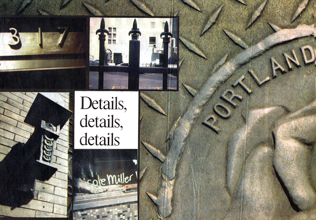
On the banks of the Willamette River in Oregon is a true city. Portland has a downtown that could be a relocated Pittsburgh, bridges and all, and walking through its sinewed city center is a glory of chattering urban detail, all screaming out that this is a real city.

For it is the details that define the urban.

a portland strip 5

Portland is filled with the tiled floors, fireplugs, storm drains, eroded curbsides, overarching trees, root-buckled sidewalks and brownstone stoops that make a city feel urban.

It is all the more significant because the Portland downtown is so tiny. You can walk almost anywhere you need to go.

Yet in those 100 miniature city blocks — less than a square mile — you can discover all the urban detail, ornament and design that you need to serve as a madeleine to your Proustian nostalgia for a citiness.

Along the sidewalk, a checkerboard of frosted glass squares underfoot illuminates an old basement.

a portland strip

A brass fire-hose connection splits like a Brancusi torso.

A dull iron streetcar track in the cobblestones is wheel-shined.

An Art Deco 317 glows above the glass doors of the Loyalty Building.

The city is built of hard, durable metals and stone, yet all its edges are softened and weathered.

There is the steep ramp of the old brick parking garage. a portland strip 2

The spear points topping the black iron fences.

The revolving clock-thermometer at the corner of the bank building.

The equestrian statue in the middle of the park, with its benches and chess players.

”Joy The Tailor” is written in mosaic on the sidewalk in front of an empty storefront. Who knows how many businesses have operated in that building since Joy left?

There is the neon ”pizza” sign in the window, a neon ”Western Union” and a neon ”color copies.” a portland strip 4 copy

In front of a blockwide pit being dug out by the steam shovel, men on their lunch hours gather in a crowd behind a fence to stand and stare. One of them is eating a Fig Newton.

The one thing all those details speak of is age. The rounded edges of the curbs, the worn writing on the manhole covers — these things come with maturity.

The younger cities of the West — or the cities such as LA that seek eternal adolescence — cannot achieve the respectable age of the Eastern cities. It is a miracle that Portland survives.

For in LA, as in Phoenix, any building older than our high-school years tends to be flattened and replaced with one of those brittle, obdurate, unweathered and machine-edged monoliths, too juvenile to know better, too inexperienced to have the wisdom time brings to sandstone and concrete.

In a real city, you see the scoops of accumulated footfalls on the marble museum steps, you see ailanthus trees growing in the unattended spaces between buildings and moss on the gutters.

A real city is a stage set for our lives. We eat at the lunch counters, recline in the grassy parks, live when we are young or very old in the plastered apartments above the storefronts, drink grappa at night in the jazz bars.

The urban city is a setting not only physically but also historically. Its worn details, visible at every turn, remind us that we live in history, too. The city was there before us and will be after us.

In a city of strident newness, such as Phoenix, we can forget the big picture and think we are all that matters. In a city full of its own past, you are always reminded of your grandparents and grandchildren.

And it is all in the details.

USACE Tillamook Bay Oregon

Tillamook has a more interesting history than most towns of its size and obscurity.

While most towns north or south of it on the Oregon coast have catered to the vacationer, with beachfront motels and seafood restaurants, Tillamook remains a working town.

And although it is situated along U.S. 101, which is the famous Coast Highway, Tillamook is back from the ocean, in a wide flat valley filled with cows and lumber.

There are also a series of prominent mud flats.

But the predominant impression is of green: vast pastures filled with cows. Tillamook is primarily a dairy town, with several cheese factories.

There is a short-line railroad with a diesel locomotive painted in the black-and-white patchwork of a Holstein cow. Tillamook Cheese Factory

Self-guided tours of the Tillamook Cheese factory are available, with samples of curd and Cheddar. The factory produces 40 million pounds of cheese each year. You can watch it being made in 40-pound cubes and then cut by automated cheese slicers into smaller familiar sizes. An small army of snood-headed women watches over the assembly line to keep track of errant chunks of cheese and misshapen cubes.

I briefly considered buying a whole 40-pound block but changed my mind when I discovered it would cost about $120.

The high school football team is known as “The Fighting Cheesemakers.”

Tillamook was also the site of the worst natural disaster in Oregon history, in 1933 with the first of a series of devastating forest fires known as the ”Tillamook Burn.”

The fire had a 15-mile front and in only two days destroyed 255,000 acres. And the fire raged for four weeks.

Fires recurred every six years until 1951, causing them to be named the ”six-year jinx.” Ultimately, 325 square miles were burned. It cost $13 million to reforest the blasted areas, which now look green and woodsy.

Natural devastation also did in the vast land speculation known as Bayocean. Beginning in 1906, a series of investors cooked up a scheme to turn a sand spit at the mouth of Tillamook Bay into a vacation paradise, with cottages, hotels and a gigantic natatorium with heated water.

Bayocean natatorium and dance hall

Bayocean natatorium and dance hall

Lots were sold, buildings were built and sales were slow, in part because there was no way to get to the development. There were neither roads nor trains, and the yacht that was supposed to carry passengers across the bay was too large to pass over the mud bars.

But more devastating was the fact that the builders hadn’t taken into account the nature of spits: They grow and shrink with the waves, and it wasn’t long before Bayocean’s cottages fell into the aggressive surf. There was a brief period of prosperity in the community during the ’20s, but by 1932 the natatorium collapsed into the sea. In 1952, a storm split the spit into three smaller islands. The last vestiges of construction on the spit were wiped out in 1960. Today, it is just a story they tell in town.

Bayocean hotel view

Bayocean hotel view

I doubt many in Tillamook still sing the popular song from 1925, Tillie From Tillamook: ”Tillamook Tillie got wild one day, packed up her things and went away. She got weary of the birds and the bees and living on Tillamook cheese.”

According to the song, she moved to Manhattan and the chorus sings out: ”Wooden shoes, a hole in her sock, knees that knock-knock, knock-knock. She’s lopsided and she got that way getting up at break of day. Tillie, Tillie, Tillie, sweeter than the new mown hay. She’s the crash of Broadway today!”

Another piece of Tillamookana, however, is still there to see, just south of town: the world’s largest wooden building. It is a blimp hangar built during World War II for the Navy. There used to be two of them, but one burned down in 1992 when its contents, $300,000 worth of straw, caught fire. The conflagration was so intense that the fire drew 80 mph winds into the hangar.

Hangar B

Hangar B

The remaining hangar for now contains the Tillamook Air Museum, with a handful of World War II-era planes, a couple of blimps and some helicopters, along with interpretive exhibits that tell the story of the hangars and the blimps that were used during the war to patrol the Pacific looking for Japanese submarines.

The building is 1,080 feet long, 300 feet wide and 195 feet high and covers 7 acres. You can’t miss it as you drive along 101. There are geological features listed on maps that are smaller than this great humpbacked mega quonset hut.

Yaquina Bay Bridge

Yaquina Bay Bridge

Forget the bridges of Madison County, the bridges worth writing about are on the Oregon coast.

As the coastline meanders in and out along the Pacific, the roadmakers were faced with two problems: how to climb the rocky headlands and how to bridge the broad, flat river estuaries. They took care of the headlands with dynamite and pick, but the rivers were something else.

First, they were unusually broad, combining, as they do, elements of river, estuary and tidal mud flat. The soft ground didn’t make it easy to anchor a bridge. Second, the usual material for building bridges in the early part of this century was iron, which tended to rust out very quickly in the salt-spray air of the coast.

Wilson River Bridge

Wilson River Bridge

Consequently, most rivers were crossed only by ferry, even after the Pacific Coast Highway was dedicated in 1923. It wasn’t until federal matching funds were made available for highway construction, and later the Works Progress Administration kicked in, that the final T’s were crossed and the last bridges were installed.

Now, bridges ordinarily don’t get me excited. I like a good bridge as much as the next guy, but I can’t claim to be a fanatic. conde mccullough

But the bridges that cross the Oregon coast are different. They are some of the most beautiful bridges ever built. And the credit goes to one exceptional man: Conde McCullough, a South Dakota-born engineer who presided over the Oregon Highway Department as bridge engineer during those critical years.

His designs are admired both for their engineering skill — he was an innovative engineer and used many new techniques, including prestressed concrete, for the first time, or very nearly so — and for their aesthetic grace.

I cannot speak with any authority on their technical aspects, but I can say that, taken as a whole, they are the most beautiful set of highway bridges I’ve ever seen.

McCullough had a few recognizable habits. He used a good deal of Art Deco ornament on the bridges. Many have decorated pylons at the entrance to the bridge. Others have abstract floral scrollwork carved into their girders.

And these certainly make the bridges distinctive.

But it isn’t the ornament that makes them so satisfying to look at; rather it is the incredible sense of proportion and rhythmic movement McCullough managed to enshrine in his steel and concrete sculptures.

Anyone who has taken notice of the mint-green steel arches between molded concrete abutments that cross the river mouths on the Oregon coast will be able to recognize McCullough’s handiwork whenever else he sees it.

Coos Bay Bridge

Coos Bay Bridge

The bridge over Coos Bay, for instance, which now is named the McCullough Memorial Bridge, is a series of long arches like the path of a bouncing ball. Over them the roadway passes, rising slightly and connected to the arches underneath with a series of vertical beams, just the same graceful thickness as the arches themselves.

Coos Bay Bridge girders

Coos Bay Bridge girders

And across the main span, an equally graceful series of steel girders crosses the roadway in a series of gothic arches, crossing themselves in a way reminiscent of the great crossed arches of Exeter Cathedral in England.

As you drive across, you can’t help but have the feeling that you are driving down some great dignified nave.

His bridge over the Rogue River is a counterpoint of tall, Roman-aqueduct-style arches against the longer bouncing-ball arches of the spans themselves. Built in 1931, it was the first structure in America to be constructed with the Freyssinet method of pre-stressing concrete and has been designated as a National Historic Civil Engineering Landmark by the American Society of Civil Engineers.

Cape Creek Bridge

Cape Creek Bridge

Three different types of arch work together in the Cape Creek Bridge at Devil’s Elbow State Park, and in the Yaquina Bay Bridge at Newport, the 3,223-foot structure is a graceful ascending line of highway supported by long, flowing arches, with a center-span arch that leaps high above the roadway. The center span is further set off by the concrete ”finials” that top off the support span.

Yaquina Bay Bridge

Yaquina Bay Bridge

A lot of money has been spent on public art, but very little is of such lasting significance as these civil projects created by an engineer who was also an artist. When McCullough died in 1946, he left a more lasting and distinct personal signature on the state than any political or social leader.

sea lion caves interior

The Pacific coast has its share of tourist traps. You can drive through the middle of redwood trees, see Paul Bunyan and Babe the Blue Ox at the Mystery Trees, or you can shop in a beached ship.

Most of these venerable stops are getting on in years and it shows in the generally seedy look of weathered paint and warped lumber.

And one of the oldest attractions on the Oregon coast had always sounded just as depressing. I had passed the Sea Lion Caves, about 10 miles north of Florence, several times, but had never deigned to go in. It was my loss. sea lion caves building

For although the caves first waylaid tourists in 1932, it is surprisingly well kept. The small shop at the top of the cliffs that serves as ticket booth and souvenir stand looks as if it were built last year.

Your ticket gets you an elevator ride 208 feet down into the cliff rock, and when you get off, you are in a subterranean cave with a gallery view of the only mainland sea-lion rookery in the world.

The star of this show is the Steller’s sea lion, the larger of the two West Coast sea lions, and you will see up to 200 of them lounging on the rock in the cave below or diving into the pounding surf that tears into the cave every few seconds.

Most people go in the summer. This is a mistake. First of all, you have to fight hoards of tourists and you are whisked down the elevator and back up in as short a time as possible to make room for the next gang.

Second, it is in the winter and spring when the sea lions come to the cave to live and breed.

I was there in December, which like most months on the Oregon coast, is the rainy season. It was 43 degrees with a steady 20 knot wind, gusting to 35 — there is a weather station on site to keep track of these things — and a constant downpour of icy rain, the kind that soaks down to the bone. sea lion caves

In the cave, you are protected from the wind, but it is just as cold and raw, and there is the added pleasure of the barks and yowls of 200 yammering sea lions, which is as loud as certain places at an airport, and the smell, which has been likened to sweat-soaked sneakers, but I say is closer to warm kimchi.

The cave itself is immense: The floor covers two acres under a cave-dome 125 feet above the surf. The waves crash into the west-facing opening and slosh and foam across the piles of rock on the cave floor, where the sea lions sit and howl at each other.

In December, too, it is very dark in the cave. The low sun and the cloudy skies make for perpetual twilight in the cave; it glows with the burnished light of a cathedral interior.

The murk hides the animals at first. It’s hard to see them, although by ear and nose, their presence is well proved.

When you adjust to the gloom, you are shocked to see hundreds of them. Some of the rocks you first saw turn out instead to be a mother and her cub. A young male stands on the peak of the highest rock and lets his throat cut loose straight up into the air.

The gallery where you stand is 50 feet above the throng, and you are separated from the main part of the cave by a chain-link fence.

I watched the goings on — which looked more than anything else I can think of like the floor of a political convention — and only later realized that one sea-lion cow was directly under me on the other side of the fence. I had thought she was a rock, but she rolled over, threw one flipper up into the air like a shark fin and used her hind flipper to scratch her ribs.

She got up and watched me watching her. She stared for some time and weaved her head back and forth, the way you see circus seals bob when performing. I weaved back at her. When she finally decided that the long nose of the big sea lion watching her was really only my ball cap, she lost interest and flopped down again to try to sleep. She must have been an insomniac, because she tossed and turned for some time trying to find the comfortable position.

The cold finally got to me. I lost feeling in my knuckles. I was the only one in the cave, except for the attendant, a genial elderly man with a cultivated New England manner of speaking.

”Not very busy today,” I ventured. ”Must be a madhouse in the summer, though.”

”It moves right along,” he said. ”Our busiest day last summer, we had 1,723 people. The elevator couldn’t get’em up and down fast enough.”

The main natural entrance to the cave was discovered by a fisherman in 1880. He later bought the property, although there wasn’t much he could do with it, as there were no roads in that part of Oregon.

It wasn’t until the Coast Highway, now U.S. 101, was built that anyone thought of developing the property. And when they did, they provided a downhill climb of a quarter mile followed by descent down 250 stairs into a secondary natural opening to the cave. It wasn’t until 1961 that an elevator was installed, making the drop to the gallery possible for anyone but the best athletes. Heceta Head Lighthouse

Now, that secondary opening is a balcony looking out to the north of the bluff where the cave is situated. And framed by the rocky window is a view of the Heceta Head lighthouse. No more archetypally Oregon coast scene could be possible: A rocky headland topped with dark green trees is crowned with the squat white shaft of the lighthouse, which beams out its flash every 10 seconds.

When I rode the elevator back up and got out into the wind at the top of the cliff, I looked out over the ocean and saw a dark gray squall moving on the surface of the water headed directly at me. I thought it a good idea to go the the souvenir shop and wait for it to pass.