Archive

Author Archives: Richard Nilsen

a portland collage

What makes a city urban?

Those who live in the Western half of the country have to wonder sometimes. For Phoenix or Los Angeles — and most trans-Mississippi cities — are fundamentally different from the core cities of the East. The Western-model cities are sprawling suburbs, spread like a great tablecloth over the landscape.

It isn’t that they don’t have character. LA has enough character for a dozen smaller cities. And even Phoenix has its personality, although it is that of a raw, unformed, undisciplined adolescent.

But for anyone who grew up near New York, Philadelphia or Boston, there is something urgently missing out here that prevents the West from becoming authentically urban.

Purists may argue that any concentration of population must be considered urban. And they are technically correct. But walk the Loop in Chicago or by the row houses of Baltimore and you instantly sense the difference.

It is true that there are small bits of citiness in the West — a neighborhood in Denver, sections of Seattle or San Francisco. But these are fragments.

There is one place that has undiluted citiness in concentration.

On the banks of the Willamette River in Oregon is a true city. Portland has a downtown that could be a relocated Pittsburgh, bridges and all, and walking through its sinewed city center is a glory of chattering urban detail, all screaming out that this is a real city.

For it is the details that define the urban.

a portland strip 5

Portland is filled with the tiled floors, fireplugs, storm drains, eroded curbsides, overarching trees, root-buckled sidewalks and brownstone stoops that make a city feel urban.

It is all the more significant because the Portland downtown is so tiny. You can walk almost anywhere you need to go.

Yet in those 100 miniature city blocks — less than a square mile — you can discover all the urban detail, ornament and design that you need to serve as a madeleine to your Proustian nostalgia for a citiness.

Along the sidewalk, a checkerboard of frosted glass squares underfoot illuminates an old basement.

a portland strip

A brass fire-hose connection splits like a Brancusi torso.

A dull iron streetcar track in the cobblestones is wheel-shined.

An Art Deco 317 glows above the glass doors of the Loyalty Building.

The city is built of hard, durable metals and stone, yet all its edges are softened and weathered.

There is the steep ramp of the old brick parking garage. a portland strip 2

The spear points topping the black iron fences.

The revolving clock-thermometer at the corner of the bank building.

The equestrian statue in the middle of the park, with its benches and chess players.

”Joy The Tailor” is written in mosaic on the sidewalk in front of an empty storefront. Who knows how many businesses have operated in that building since Joy left?

There is the neon ”pizza” sign in the window, a neon ”Western Union” and a neon ”color copies.” a portland strip 4 copy

In front of a blockwide pit being dug out by the steam shovel, men on their lunch hours gather in a crowd behind a fence to stand and stare. One of them is eating a Fig Newton.

The one thing all those details speak of is age. The rounded edges of the curbs, the worn writing on the manhole covers — these things come with maturity.

The younger cities of the West — or the cities such as LA that seek eternal adolescence — cannot achieve the respectable age of the Eastern cities. It is a miracle that Portland survives.

For in LA, as in Phoenix, any building older than our high-school years tends to be flattened and replaced with one of those brittle, obdurate, unweathered and machine-edged monoliths, too juvenile to know better, too inexperienced to have the wisdom time brings to sandstone and concrete.

In a real city, you see the scoops of accumulated footfalls on the marble museum steps, you see ailanthus trees growing in the unattended spaces between buildings and moss on the gutters.

A real city is a stage set for our lives. We eat at the lunch counters, recline in the grassy parks, live when we are young or very old in the plastered apartments above the storefronts, drink grappa at night in the jazz bars.

The urban city is a setting not only physically but also historically. Its worn details, visible at every turn, remind us that we live in history, too. The city was there before us and will be after us.

In a city of strident newness, such as Phoenix, we can forget the big picture and think we are all that matters. In a city full of its own past, you are always reminded of your grandparents and grandchildren.

And it is all in the details.

columbia river gorge panorama

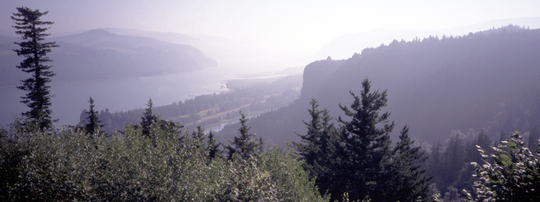
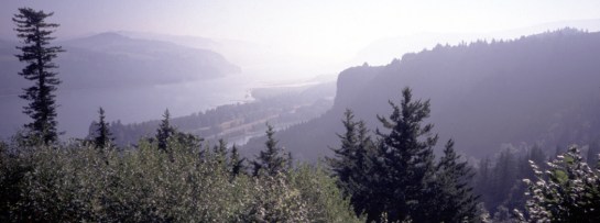
Imagine another Yosemite Valley, only 10 times larger and with a great river running through it, with twice the flow of the Nile.

The Columbia River Gorge, between Oregon and Washington, is just such a place. And if it had not been settled and its river used for commerce from its earliest discovery, it would have been a cinch to be made a national park.

Even so, it is still a National Scenic Area and runs 80 miles from near rain forest in the west to near desert in the east. It is a scenic prodigy.

Mt. Hood

Mt. Hood


You can see its immensity best perhaps from the air. Flying up the Willamette Valley into Portland, Ore., the Cascade Mountains stretch out to the east like a great rumpled bedspread, green with trees. Above the range are the white, snowcapped cones of the huge volcanoes — the Three Sisters, Mount Jefferson and Mount Hood, piled Ossa-on-Pelion above the greener peaks below.

As the plane turns west to land, you can see the Cascades continue north to Canada, and the white pyramids piled on top include Mount Adams, Mount St. Helens and, way out on the horizon, the biggest of all, Mount Rainier.

But gouged out of the mountains, running east and west in the space between Hood and Adams, the gorge looks like a giant slice taken from the middle of a continental meatloaf.

From the air, you can get some sense of the proportions of the gorge. It becomes easier to understand the geological processes that formed it, from the greenish Ohanapecosh Formation of mostly metamorphic rocks, some 40 million years old, to the many basalt flows and volcanoes that poured through the mountain valleys.

Most astonishing might be the great floods that tore through the gorge during the Ice Age, some 15,000 years ago.

Melting water had backed up across Idaho and Montana behind a dam of ice half a mile high. When the dam broke, 500 cubic miles of water — a fifth the volume of Lake Michigan — churned across eastern Washington and through the narrow gorge. Water left its mark 1,000 feet above the present-day city of The Dalles.

The Dalles

The Dalles

It is hard to comprehend the strength of the water. Nearly 10 cubic miles of water poured through the valley every hour for more than 40 hours — 10 times the flow of all the rivers in the world combined. It washed eastern Washington bare, leaving behind the area we now call the Channeled Scablands, still largely naked rock.
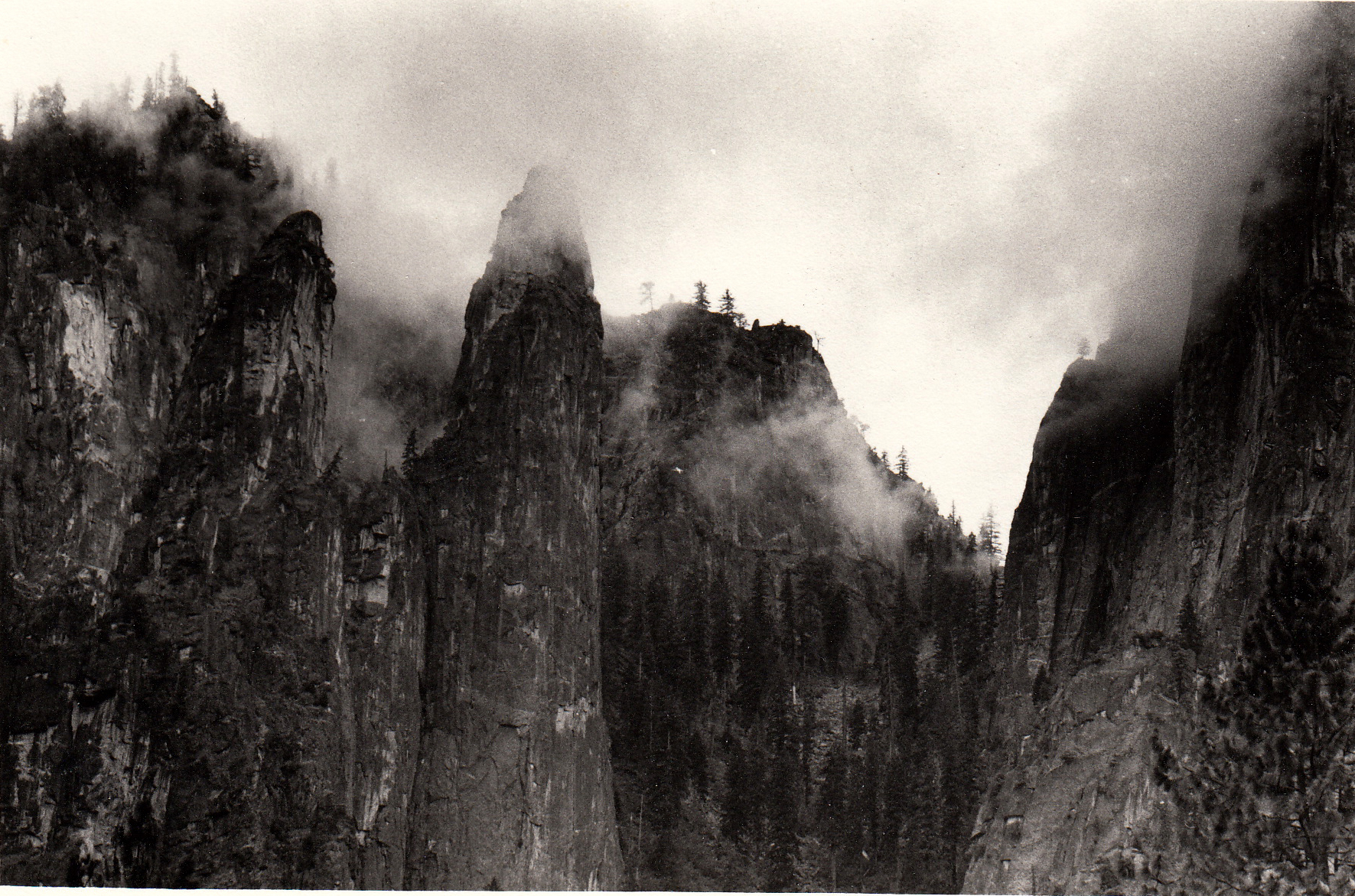
The Scablands

The Scablands

The ice dams reformed and rebroke as many as 100 times. Geologists believe the floods occurred on average about every 55 years for 2,000 years, widening and reshaping the Columbia River Gorge into its current U-shape.

Indians lived along the river as long ago as 10,000 years. Europeans first sailed up it shortly after the American Revolution and an American named the river after his ship, Columbia Rediviva, in 1792.

But it was the Lewis and Clark Expedition that literally put the river on the map.

The expedition followed the river to the coast in 1805 and camped there over winter, looking for a clear Northwest Passage from the East Coast to the West Coast.

By 1840, the Oregon Trail brought hordes of immigrants to the area, looking to farm and build new cities.

They came down the river, by road where possible, but across the watery rapids in the tighter sections where no roadbed was possible.

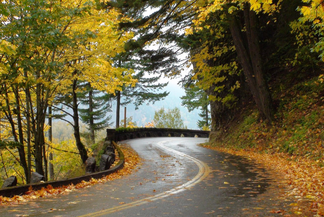
Nowadays, Interstate 84 follows the river’s south shore, or Oregon side, but it wasn’t until 1913 that anyone tried to find a way to build a continuous road through the gorge. scenic highway

That road, the Columbia River Gorge Scenic Highway, has been superseded and largely obliterated by the interstate, but sections of it are still driveable — 22 miles from Troutdale to Dodson and nine miles from Mosier to Rowena.

You can get the big picture from the air, but to really know the beauty of the gorge, you need to be on more intimate terms, and the remnants of the old highway — now called the Historic Columbia River Highway — are the best way to do that.

Beginning in Troutdale, you drive across the Sandy River toward Springdale. The road stays on the back side of the ridge, so you cannot see the river until you get to Portland Women’s Forum State Park, where a small parking lot affords a grand view up the gorge. You are on a bluff some 700 feet above the water, and the mountains pale into powdery blue as they recede. In the rake of morning light, it looks like a Chinese ink painting.

A mile or so down the road, the next outlook comes at Crown Point and the historic Vista House built in 1916. The octagonal building serves as a visitor center for the gorge and has exhibits and a very good gift shop.

View from Crown Point

View from Crown Point

It also has views for 30 miles in each direction.

The highway climbs down the river side of the ridge and begins to follow the water and the interstate. Nevertheless, this section from Latourell Falls to Horsetail Falls is the highlight of the trip.

The river is lined with a thousand-foot cliff, some 10 miles long, over which cascade more waterfalls per mile than any place in the world outside Hawaii.

They jump off the top of the cliff and pour, almost in slow, misty motion, to the pool below. With names like Mist Falls, Bridal Veil Falls and Punch Bowl Falls, they give you a sense of almost tropical richness.

Multnomah Falls

Multnomah Falls

Indeed, just above the most famous of them, Multnomah Falls — with its parking lot and lodge — sits Larch Mountain, where the annual rainfall is 200 inches.

Another 50 miles down the gorge, at The Dalles, the rainfall drops to 12 inches a year.

The best view of the dry, eastern end of the gorge is from Rowena Crest, where an overlook sits like an aerie over the dry basalt hills near The Dalles. Grass is yellow in the summer, and you sometimes can look out over the shoulders of hawks.

The eastern end of the gorge also can be quite hot. In July, the temperatures easily can top 110.

If you continue east on Interstate 84, past the Deschutes River, you can cross the Columbia on the Sam Hill Memorial Bridge at Biggs.

Once across and in Washington, there are two other Sam Hill monuments you should see.

Hill was the Washington mover and shaker who managed to get the early highway built. He also constructed a mansion for himself out in the blasted rocky grasslands. He called it Maryhill, and it is now an art museum with a respectable collection of work, specializing in Russian icons, art chess sets and the sculpture of Rodin.

But the oddest Hill monument is the concrete Stonehenge he built in 1918 as a memorial for the war dead of Washington’s Klickitat County. The imitation Stonehenge was meant to look like the original did when new, so it has a strangely antiseptic look, without the patina that age gives history. Maryhill stonehenge WWI monument

Coming back through the gorge on the north shore along Washington 14 — known as the Lewis and Clark Highway — you retrace your route with a whole different look. The desert gives way to the trees, and the smaller road twists around headlands and coves.

At Stevenson, Wash., the Columbia Gorge Interpretive Center has exhibits not only on the geography of the area but also its history and culture.

And near North Bonneville, the great Bonneville Dam blocks the river flow in five disjointed segments between four islands. It was one of the great public works projects of the Great Depression and opened in 1938.

Bonneville Dam

Bonneville Dam

There are modern visitor centers accessible from each shore.

The Bradford Island Visitor Center, reached from the Oregon side, is the larger, but the Washington Shore Visitor Center has the better view of the powerhouses with their huge generators.

Further along, Beacon Rock stands like a giant upended football, 848 feet high, with a hairpin stairway up its side for adventurous climbers. It was named by Lewis and Clark and marks the beginning of Columbia River tidewater.

Beacon Rock

Beacon Rock

The final monumental attraction of the trip is the skirting of Mount Pleasant and the section called Cape Horn, where the road barely holds onto the rock wall. Several turnouts offer a final glorious view of the gorge.

All along the way, there are state parks and nature preserves. Wildflowers are startling, hiking is popular and so is bicycling.

And above everything, you get the occasional unblocked view of white-headed Mount Hood, a beautiful, symmetrical volcano that is the symbol of the area.

fort clatsop brochure

Most people visit Fort Clatsop in the summer and so miss understanding history. The only proper way to see it is in midwinter, when the air is as raw as frozen hamburger and the rain drizzles down into the fibers of your clothing.

Fort Clatsop National Memorial is just a few miles from Astoria, Ore., and is where the Lewis and Clark expedition spent four cold months in 1805-06, waiting for the spring thaw so they could return to civilization. Meriwether Lewis and George Clark had led an expedition of 45 men up the Missouri River beginning in 1804, exploring the Louisiana Territory that President Thomas Jefferson had just bought from France. Lewis and Clark were charged with finding a way through the territory to the Pacific Ocean on the other side of the continent.

They spent two summers and a winter getting to the Pacific and another winter camped at Fort Clatsop, which they built as temporary quarters and a way to keep some of the constant rain off their heads. Of the 106 days they spent at the fort, the sun shone for six. fort clatsop fog

Life was constant misery. According to their journal entry for the day after Christmas, 1805, ”rained and blew hard last night, some hard Thunder. The rain continued as usial all day and wind blew hard from the S.E. Joseph Fields finish a Table & 2 seats for us. we dry our wet articles and have the blankets fleed, The flees are so troublesom that I have slept but little for 2 night past and we have regularly to kill them out of our blankets every day for several past. maney of the men have ther Powder wet by the horns being repeatedly wet, hut smokes verry bad.

Lewis and Clark were not hired for their spelling.

The original fort is long since returned to the soil it came out of. But a copy of the original, built from the description and plans in the expedition journals, has arisen in the original location.

The fleas have not been re-created for the modern visitor.

It is a very small fort by the standards of anyone who has seen palisaded forts in John Wayne Westerns. It is exactly 50-feet square and divided into eight rooms, three on one side and five on the other, with an open plaza between them. This was technically called the ”parade ground,” but no parade longer than a pace and a half would be possible in its Lilliputian length. Fort Clatsop interior

The largest room went to Lewis and Clark. The three smaller rooms on one side were given over to the remaining crew, up to 15 per room. And the smallest quarters, next to the commanders’, was given to the French trapper Touissant Charboneau and his Indian wife, Sacagawea, and their infant baby. The remaining small rooms were a meeting room and a supply closet. sacagawea dollar

In December, when you should visit the fort, fires crackle in the hearths of the rooms and volunteers give demonstrations of some of the things the explorers had to do.

A class of visiting high-school students was divided into a group that used rod and chain to learn primitive surveying and mapping techniques; another group that attempted to write with quill pens; a third group that made candles out of tallow; a fourth group that learned how to blow a glowing flint-and-steel spark into a flame; and a fifth group that heard about animal furs.

The smell of wood smoke penetrated everything. Hours later, I still could smell it in my coat. The smoke hung low above the log-cabin fort, which is a sign that canny weather watchers can use to predict rain. As if the prediction were necessary for an Oregon winter.

In 1805-06, the men came down with influenza and other sicknesses brought on by exposure. They managed to kill and eat 131 elk and 20 deer.

Lewis and Clark had to leave the fort earlier than planned when the early spring thaw drove the elk up into the surrounding mountains and left the men without a dependable menu. fort clatsop postcard

”We have not fared sumptuously this winter and spring,” they wrote in the journal as they prepared to break camp.

And when they reversed their route, they returned to St. Louis in half the time it took them to go out.

USACE Tillamook Bay Oregon

Tillamook has a more interesting history than most towns of its size and obscurity.

While most towns north or south of it on the Oregon coast have catered to the vacationer, with beachfront motels and seafood restaurants, Tillamook remains a working town.

And although it is situated along U.S. 101, which is the famous Coast Highway, Tillamook is back from the ocean, in a wide flat valley filled with cows and lumber.

There are also a series of prominent mud flats.

But the predominant impression is of green: vast pastures filled with cows. Tillamook is primarily a dairy town, with several cheese factories.

There is a short-line railroad with a diesel locomotive painted in the black-and-white patchwork of a Holstein cow. Tillamook Cheese Factory

Self-guided tours of the Tillamook Cheese factory are available, with samples of curd and Cheddar. The factory produces 40 million pounds of cheese each year. You can watch it being made in 40-pound cubes and then cut by automated cheese slicers into smaller familiar sizes. An small army of snood-headed women watches over the assembly line to keep track of errant chunks of cheese and misshapen cubes.

I briefly considered buying a whole 40-pound block but changed my mind when I discovered it would cost about $120.

The high school football team is known as “The Fighting Cheesemakers.”

Tillamook was also the site of the worst natural disaster in Oregon history, in 1933 with the first of a series of devastating forest fires known as the ”Tillamook Burn.”

The fire had a 15-mile front and in only two days destroyed 255,000 acres. And the fire raged for four weeks.

Fires recurred every six years until 1951, causing them to be named the ”six-year jinx.” Ultimately, 325 square miles were burned. It cost $13 million to reforest the blasted areas, which now look green and woodsy.

Natural devastation also did in the vast land speculation known as Bayocean. Beginning in 1906, a series of investors cooked up a scheme to turn a sand spit at the mouth of Tillamook Bay into a vacation paradise, with cottages, hotels and a gigantic natatorium with heated water.

Bayocean natatorium and dance hall

Bayocean natatorium and dance hall

Lots were sold, buildings were built and sales were slow, in part because there was no way to get to the development. There were neither roads nor trains, and the yacht that was supposed to carry passengers across the bay was too large to pass over the mud bars.

But more devastating was the fact that the builders hadn’t taken into account the nature of spits: They grow and shrink with the waves, and it wasn’t long before Bayocean’s cottages fell into the aggressive surf. There was a brief period of prosperity in the community during the ’20s, but by 1932 the natatorium collapsed into the sea. In 1952, a storm split the spit into three smaller islands. The last vestiges of construction on the spit were wiped out in 1960. Today, it is just a story they tell in town.

Bayocean hotel view

Bayocean hotel view

I doubt many in Tillamook still sing the popular song from 1925, Tillie From Tillamook: ”Tillamook Tillie got wild one day, packed up her things and went away. She got weary of the birds and the bees and living on Tillamook cheese.”

According to the song, she moved to Manhattan and the chorus sings out: ”Wooden shoes, a hole in her sock, knees that knock-knock, knock-knock. She’s lopsided and she got that way getting up at break of day. Tillie, Tillie, Tillie, sweeter than the new mown hay. She’s the crash of Broadway today!”

Another piece of Tillamookana, however, is still there to see, just south of town: the world’s largest wooden building. It is a blimp hangar built during World War II for the Navy. There used to be two of them, but one burned down in 1992 when its contents, $300,000 worth of straw, caught fire. The conflagration was so intense that the fire drew 80 mph winds into the hangar.

Hangar B

Hangar B

The remaining hangar for now contains the Tillamook Air Museum, with a handful of World War II-era planes, a couple of blimps and some helicopters, along with interpretive exhibits that tell the story of the hangars and the blimps that were used during the war to patrol the Pacific looking for Japanese submarines.

The building is 1,080 feet long, 300 feet wide and 195 feet high and covers 7 acres. You can’t miss it as you drive along 101. There are geological features listed on maps that are smaller than this great humpbacked mega quonset hut.

Yaquina Bay Bridge

Yaquina Bay Bridge

Forget the bridges of Madison County, the bridges worth writing about are on the Oregon coast.

As the coastline meanders in and out along the Pacific, the roadmakers were faced with two problems: how to climb the rocky headlands and how to bridge the broad, flat river estuaries. They took care of the headlands with dynamite and pick, but the rivers were something else.

First, they were unusually broad, combining, as they do, elements of river, estuary and tidal mud flat. The soft ground didn’t make it easy to anchor a bridge. Second, the usual material for building bridges in the early part of this century was iron, which tended to rust out very quickly in the salt-spray air of the coast.

Wilson River Bridge

Wilson River Bridge

Consequently, most rivers were crossed only by ferry, even after the Pacific Coast Highway was dedicated in 1923. It wasn’t until federal matching funds were made available for highway construction, and later the Works Progress Administration kicked in, that the final T’s were crossed and the last bridges were installed.

Now, bridges ordinarily don’t get me excited. I like a good bridge as much as the next guy, but I can’t claim to be a fanatic. conde mccullough

But the bridges that cross the Oregon coast are different. They are some of the most beautiful bridges ever built. And the credit goes to one exceptional man: Conde McCullough, a South Dakota-born engineer who presided over the Oregon Highway Department as bridge engineer during those critical years.

His designs are admired both for their engineering skill — he was an innovative engineer and used many new techniques, including prestressed concrete, for the first time, or very nearly so — and for their aesthetic grace.

I cannot speak with any authority on their technical aspects, but I can say that, taken as a whole, they are the most beautiful set of highway bridges I’ve ever seen.

McCullough had a few recognizable habits. He used a good deal of Art Deco ornament on the bridges. Many have decorated pylons at the entrance to the bridge. Others have abstract floral scrollwork carved into their girders.

And these certainly make the bridges distinctive.

But it isn’t the ornament that makes them so satisfying to look at; rather it is the incredible sense of proportion and rhythmic movement McCullough managed to enshrine in his steel and concrete sculptures.

Anyone who has taken notice of the mint-green steel arches between molded concrete abutments that cross the river mouths on the Oregon coast will be able to recognize McCullough’s handiwork whenever else he sees it.

Coos Bay Bridge

Coos Bay Bridge

The bridge over Coos Bay, for instance, which now is named the McCullough Memorial Bridge, is a series of long arches like the path of a bouncing ball. Over them the roadway passes, rising slightly and connected to the arches underneath with a series of vertical beams, just the same graceful thickness as the arches themselves.

Coos Bay Bridge girders

Coos Bay Bridge girders

And across the main span, an equally graceful series of steel girders crosses the roadway in a series of gothic arches, crossing themselves in a way reminiscent of the great crossed arches of Exeter Cathedral in England.

As you drive across, you can’t help but have the feeling that you are driving down some great dignified nave.

His bridge over the Rogue River is a counterpoint of tall, Roman-aqueduct-style arches against the longer bouncing-ball arches of the spans themselves. Built in 1931, it was the first structure in America to be constructed with the Freyssinet method of pre-stressing concrete and has been designated as a National Historic Civil Engineering Landmark by the American Society of Civil Engineers.

Cape Creek Bridge

Cape Creek Bridge

Three different types of arch work together in the Cape Creek Bridge at Devil’s Elbow State Park, and in the Yaquina Bay Bridge at Newport, the 3,223-foot structure is a graceful ascending line of highway supported by long, flowing arches, with a center-span arch that leaps high above the roadway. The center span is further set off by the concrete ”finials” that top off the support span.

Yaquina Bay Bridge

Yaquina Bay Bridge

A lot of money has been spent on public art, but very little is of such lasting significance as these civil projects created by an engineer who was also an artist. When McCullough died in 1946, he left a more lasting and distinct personal signature on the state than any political or social leader.

sea lion caves interior

The Pacific coast has its share of tourist traps. You can drive through the middle of redwood trees, see Paul Bunyan and Babe the Blue Ox at the Mystery Trees, or you can shop in a beached ship.

Most of these venerable stops are getting on in years and it shows in the generally seedy look of weathered paint and warped lumber.

And one of the oldest attractions on the Oregon coast had always sounded just as depressing. I had passed the Sea Lion Caves, about 10 miles north of Florence, several times, but had never deigned to go in. It was my loss. sea lion caves building

For although the caves first waylaid tourists in 1932, it is surprisingly well kept. The small shop at the top of the cliffs that serves as ticket booth and souvenir stand looks as if it were built last year.

Your ticket gets you an elevator ride 208 feet down into the cliff rock, and when you get off, you are in a subterranean cave with a gallery view of the only mainland sea-lion rookery in the world.

The star of this show is the Steller’s sea lion, the larger of the two West Coast sea lions, and you will see up to 200 of them lounging on the rock in the cave below or diving into the pounding surf that tears into the cave every few seconds.

Most people go in the summer. This is a mistake. First of all, you have to fight hoards of tourists and you are whisked down the elevator and back up in as short a time as possible to make room for the next gang.

Second, it is in the winter and spring when the sea lions come to the cave to live and breed.

I was there in December, which like most months on the Oregon coast, is the rainy season. It was 43 degrees with a steady 20 knot wind, gusting to 35 — there is a weather station on site to keep track of these things — and a constant downpour of icy rain, the kind that soaks down to the bone. sea lion caves

In the cave, you are protected from the wind, but it is just as cold and raw, and there is the added pleasure of the barks and yowls of 200 yammering sea lions, which is as loud as certain places at an airport, and the smell, which has been likened to sweat-soaked sneakers, but I say is closer to warm kimchi.

The cave itself is immense: The floor covers two acres under a cave-dome 125 feet above the surf. The waves crash into the west-facing opening and slosh and foam across the piles of rock on the cave floor, where the sea lions sit and howl at each other.

In December, too, it is very dark in the cave. The low sun and the cloudy skies make for perpetual twilight in the cave; it glows with the burnished light of a cathedral interior.

The murk hides the animals at first. It’s hard to see them, although by ear and nose, their presence is well proved.

When you adjust to the gloom, you are shocked to see hundreds of them. Some of the rocks you first saw turn out instead to be a mother and her cub. A young male stands on the peak of the highest rock and lets his throat cut loose straight up into the air.

The gallery where you stand is 50 feet above the throng, and you are separated from the main part of the cave by a chain-link fence.

I watched the goings on — which looked more than anything else I can think of like the floor of a political convention — and only later realized that one sea-lion cow was directly under me on the other side of the fence. I had thought she was a rock, but she rolled over, threw one flipper up into the air like a shark fin and used her hind flipper to scratch her ribs.

She got up and watched me watching her. She stared for some time and weaved her head back and forth, the way you see circus seals bob when performing. I weaved back at her. When she finally decided that the long nose of the big sea lion watching her was really only my ball cap, she lost interest and flopped down again to try to sleep. She must have been an insomniac, because she tossed and turned for some time trying to find the comfortable position.

The cold finally got to me. I lost feeling in my knuckles. I was the only one in the cave, except for the attendant, a genial elderly man with a cultivated New England manner of speaking.

”Not very busy today,” I ventured. ”Must be a madhouse in the summer, though.”

”It moves right along,” he said. ”Our busiest day last summer, we had 1,723 people. The elevator couldn’t get’em up and down fast enough.”

The main natural entrance to the cave was discovered by a fisherman in 1880. He later bought the property, although there wasn’t much he could do with it, as there were no roads in that part of Oregon.

It wasn’t until the Coast Highway, now U.S. 101, was built that anyone thought of developing the property. And when they did, they provided a downhill climb of a quarter mile followed by descent down 250 stairs into a secondary natural opening to the cave. It wasn’t until 1961 that an elevator was installed, making the drop to the gallery possible for anyone but the best athletes. Heceta Head Lighthouse

Now, that secondary opening is a balcony looking out to the north of the bluff where the cave is situated. And framed by the rocky window is a view of the Heceta Head lighthouse. No more archetypally Oregon coast scene could be possible: A rocky headland topped with dark green trees is crowned with the squat white shaft of the lighthouse, which beams out its flash every 10 seconds.

When I rode the elevator back up and got out into the wind at the top of the cliff, I looked out over the ocean and saw a dark gray squall moving on the surface of the water headed directly at me. I thought it a good idea to go the the souvenir shop and wait for it to pass.

Eureka flooding

Winter means rain in Northern California, and I visited when winter meant more rain than usual. Of course, it is the rain that makes the area so green.

But as I drove from Sacramento to the coast, it poured constantly. My window fogs, and I could barely see for 140 miles till I got to Willits, on U.S. 101, the ”Redwood Highway,” which I planned to take to Eureka, an additional 130 miles up the coast. US101 sign

Unfortunately, a flashing sign by the side of the road in Willits tells me, ”Road Closed 125 miles . . . no detour,” which means that I’m cut off from my destination, and the only way around the problem is to drive back to the interior of the state — a backtrack of nearly 300 miles.

So I make a calculated gamble and push on north despite the sign, hoping that whatever the problem is, it might be corrected in the 2-1/2 hours it will take me to reach it.

If my gamble fails, I have an even longer return trip, just to get back to square one. At least it would be one of the most beautiful drives in the world — 101 passes both redwood country and the Northern California coast.

Even on a day of torrential downpour, there is still much to see. Near Benbow, the road snakes leisurely through the Richardson Grove of redwoods, where even when it rains, the windshield stays dry, with the evergreen umbrella several hundred feet overhead.

The farther north I get, however, the emptier the road becomes. I can drive for miles through the green hillsides without passing another car in either direction. I must admit, it does not look promising.

As I drive past the turnoff for the Avenue of the Giants in Phillipsville, the Eel River is a swollen chocolate torrent. Each time the road crosses the river, it looks angrier.

By the time I hit Fortuna on the Sandy Prairie just south of Eureka, the rain has abated, but the road is still a sloppy mess.

And it all comes to a halt at the Loleta offramp. Another flashing sign warns, ”Road Closed,” and a line of cars and trucks a mile long is stock-still.

A friendly CalTrans worker has parked his dump truck in the middle of the road and is directing the motionless line up the offramp. I ask him what’s going on and he explains that Salmon Creek has flooded the highway, pushed back on the muddy tidal flats by the incoming tide.

”Two to three feet of water on the pavement,” he says. ”Been like that since 5 p.m. yesterday.”

The result is that the entire northwestern corner of the state is incommunicado. There is no way between the north and the south. klamath river bear

It may seem odd that a state as big as California, and one that relies as much on the tourist dollar, would allow the possibility that only a single line of asphalt might run through the area. It is true that the mountains are difficult to engineer roads through, but the fact is that there is a 90-mile stretch of mountain with no paved roads running east-west, and only the single strand of 101 going north-south.

In fact, this lack of roads has always been a sore point in Northern California. The residents have felt neglected by their state government, so much so that in 1941, the northern counties of California and the southern counties of Oregon, who felt likewise forgotten, attempted to secede from their states and form a new state called Jefferson.

Roadblocks were put up on the few highways there were, Yreka was chosen state capital and Judge John C. Childs was inaugurated as governor.

The whole thing was only half serious and half publicity stunt, and it all came to a crashing halt with Pearl Harbor. But that wasn’t the first time the region had talked secession. Earlier attempts to form the states of Shasta, and later, Klamath, came to naught in the 19th century.

There is still a feeling of independence in the area.

”For us, California doesn’t start till you get to Willits,” the CalTrans worker told me as we sat in gridlock on the road.

Then came the break: With the change of tides, the water was receding and, although the northbound lane of 101 was still underwater, the slightly higher southbound lane was passable, in convoy with a highway-patrol car in the lead. Eureka farmland

First the southbound traffic came through and passed us. A few drivers gave the CalTrans worker a big thumbs up and a smile.

”On this side, when they’re freed up, they give us the thumb, when they’re stuck going nowhere, it’s a different finger. Then we’re nobody’s friend.”

The fact is that the region has been staggered by near-record rainfall. In the 24-hour period before I drove up the highway in December, just under 5 inches of rain fell, just hundredths of an inch shy of the record. And 2 more inches had fallen this morning. Schools were closed, roads were underwater everywhere. Nearby Ferndale was partly evacuated. Power lines were out and communities were stockpiling sandbags.

Whole farms were lakes. I passed a herd of very worried cattle, which were mooing up a storm. The calves sounded frightened, up to their hocks in water.

So what could make me venture 140 miles up a road I knew to be closed? Why did I make the gamble?

Because of the Samoa Cookhouse. samoa cookhouse2

Eureka is a logging town, and the last remaining logging-company cookhouse remains in business and open to the public on the spit of sand across Humboldt Bay from Eureka.

In the building originally constructed for workers of the Hammond Lumber Co. in 1906, and now owned by Louisiana Pacific, a concessionaire operates the cookhouse as a restaurant using the original kitchen and providing authentic menus. samoa cookhouse tables

In the four huge dining rooms, up to 300 people sit 10 at a table to eat family-style meals of multiple entrees.

For $10.95, I had soup and salad, followed by roast beef and fried pork-chop steaks, with baked potato, vegetables and homemade bread cut into inch-thick slices. Dessert was apple pie.

The menu varies from day to day. You don’t have a choice, you eat what they’re cooking, but you can’t complain.

”Second helpings can be had on anything in the place,” the waitress explains.

Few people could feel the need.

Perhaps the most popular meal is breakfast, which starts at 6 a.m., and consists of flapjacks, eggs, sausage, juice, bread and jam and coffee. The cookhouse is open seven days a week for all three meals and is worth braving the possibility of a 300-mile detour.

Near Bruhel's Point, Mendocino Cty, Calif

Near Bruhel Point in northern California, the rocky cliffs look out over the Pacific Ocean in a way that is common to much of the northern coast.

From the top of the bluffs, the view is spectacular; it seems as if you can see everything. But don’t be fooled: It’s a lie.

Everywhere, when you take the time, the hidden secrets of place slowly let themselves be seen, as if they were cats waiting to test you out and see if you are friend or foe.

As the landscape allows you nearer, you find details and surprises.

The narrow sandy beach was perhaps a hundred feet below and we could see no way down but to climb. What we couldn’t tell was that the hillside was so steep and so gravelly, that we began to slip and slide, tossing pebbles every which way. They only prudent way to descend was on our backsides.

The surf crashed around the rocks that stuck out of the sand off shore. The biggest of the rocks was about 40 feet high and had trees growing on its summit. The others were smaller and grew bushes, lichen, mosses and nearer the tide line, barnacles and sea weed.

All around were poppies and a variety of succulent phlox that seemed to carpet all the drier rocks in yellow flowers.bruhel point tidal pool starfish

At the tideline the hidden world opens up in a delight of color and textures. The starfish clinging to the tide-wet rocks were maroon and ocher, with a knobbly surface that seemed artificial. They moved slowly over the crust of barnacles enjoying the tidepool version of the businessman’s lunch.

Another pool was full of anemones and purple sea urchins.

Echinoderms live on a different clock from us. They sway and move with the infinite deliberation of a bomb squad.

But for every hidden treasure you find, there is a payment to be made.

We enjoyed our visit there for about an hour and then started worrying about how we were going to climb back up to the car.

We wandered down the beach looking for an easier climb and found what looked like a good way out at the creek mouth. All along the coast, there are headlands that jut out toward the sea and coves cut back into the mainland where streams let out. The hill was less steep there, but there was small shanty built under the trees there and we didn’t know if we would be disturbing anyone.

It was then that we spotted the two large and hungry-looking German shepherd guard dogs legging it to us at an alarming speed. They bore down on us with all the fury of avenging gods, protecting the sacred center of the Earth.

So with teeth flying and paws scratching sand, they ran up to us barking like schizophrenics.

At such times, you don’t know what you will do. I stood in front of my wife to protect her, wondering if a swift kick to the nose would discourage the hounds.

When they reached a point about 10 feet from us, I heard a sound come out of my mouth, with all the authority I could muster:

“Sit!!!”

The two hounds came to a toe-nail scratching halt, looked at me quizzically for a second or two, barked, snarled, whimpered and then sat down and wagged their tails.

We edged ourselves away slowly in the shallow water and along the beach, away from the dogs; they sat for a few seconds and then retreated to the shanty.Bruhel's Point, Calif 2

Eventually, we found a spot a little less steep than the one we descended and, with hard work and diligence worthy of Horatio Alger, we scratched our way back up to the top. We swigged some water, collected our thoughts and eased the car back onto the road.

About a hundred yards down the highway, we found a set of stairs that descended all the way to the beach. It had been hidden from us by a small headland of rock.

If I were Montaigne, I might find a moral in that.

pacific coast highway

The Pacific Coast Highway travels up the western edge of the North American continent like the vein down the back of a shrimp. 

It has claim to being the single most scenic road in America, passing between the mountains and the sea for 1,500 miles from Southern California to Puget Sound in Washington. 

There may be shorter sections of other roads through the Rocky Mountains or the Appalachians that are equally stunning, but nothing approaches the Pacific Coast Highway for glory over so long a haul. 

If you pick it up in San Francisco, you cross the Golden Gate Bridge and north of the city, you take the cutoff for California Highway 1, leaving behind U.S. 101, and head for the hills. The road to the coast is so curvy and filled with switchbacks, you swear to give up driving altogether. But it finally breaks out onto the sea, and the ride is one of the best in the world.PCH north of SF

The northern half of the Pacific Coast Highway is notable for its quiet emptiness, but that doesn’t mean there is nothing to do. 

Among the attractions you will pass on the Pacific Coast Highway driving from San Francisco to Olympia, Wash.: 

Marin Headlands National Recreation Area — Within sight of the Golden Gate Bridge, the headlands rise above the frequent fog and provide hiking, beaches, history and a Nike missile silo. golden gate bridge in fog

Muir Woods National Monument — One of the great groves of redwood trees, just a short hop from the city and great place for a quiet walk in the woods. 

Bolinas — The small town at the south end of Point Reyes doesn’t encourage tourism. Its citizens have been known to take down the road sign out on the highway to mislead travelers. But it so beautiful a town you can understand why they want to keep it to themselves. 

Point Reyes National Seashore — California 1 rides literally atop the San Andreas fault along the eastern edge of Point Reyes. On the other side, a renegade tectonic plate slowly has floated from Southern California to its current location north of San Francisco. Its hills, beaches and farms eventually will move north to Alaska, but give it a few million years to do so.

We’ll take the road further north, but let’s now consider the southern part of the route. We’ve already covered the glory of the Big Sur, but not all of the southern half of the road is quite so sublime. 

It is, of course, not a single highway, but a confusion of roads, for the PCH, as it is known in LA, is not an official name but a popular one, and it covers several U.S. and state route numbers. 

It is best known, for instance, as the beach road in Santa Monica. You will hear natives say they are going to take the PCH to Point Dume or Leo Carrillo State Beach, but the map of the area shows that the road they drive actually is called Palisades Beach Road. 

What is more, when it was cut through the bluff bottom in 1929, it was called the Roosevelt Highway. That is still its secondary name. 

It is also California Route 1. Through most of the state, the PCH follows California 1 and U.S. 101, hugging the coast and its scenery. 

The PCH is born haltingly and in patches south of Los Angeles. 

If you drive north from San Diego, you will be able to skirt the ocean through the city suburbs. California S21 goes through Del Mar and Cardiff-by-the-Sea, but north of Oceanside, you have no choice: You have to get on the interstate. Interstate 5 goes through Camp Pendleton and San Clemente to the actual origin of California 1 near San Juan Capistrano. 

As it travels north through Orange County and Los Angeles, California 1 is just a city street, blocked with stoplights and suffocated with traffic. It isn’t until Santa Monica that it develops its character. The spiritual beginning of the highway is where Interstate 10 ends and dumps out on the PCH under the muddy slumping palisades past the Santa Monica Pier. PCH begins at santa monica

This is the beach California is famous for — surfers and frozen yogurt shops, lifeguard stands and parking lots crammed to the gills with shiny Hondas and Toyotas. The land of swelling bikinis and glistening sunglasses. 

On summer weekends, the traffic is bumper to bumper through Topanga Beach and Malibu. It doesn’t let up — and then only a little — till past Point Dume. But the wait is worth it as the natural world reasserts itself at El Matador, El Pescador and Leo Carrillo state beaches. PCH at_Gladstones Malibu

And if you are lucky enough to be there at midweek in midwinter, you can have the beach all to yourself. Los Angeles is just a bad urban memory. 

For the next 100 miles, the road alternates between beach and city, passing Oxnard, Santa Barbara and San Luis Obispo on one hand and Point Magu, Refugio Beach and Pismo Beach on the other. The road takes a long inland detour around Vandenberg Air Force Base, through Lompoc, beloved foil for W.C. Fields, and although the ocean is hidden, the grassy golden hills of California make a fitting substitute. 

It is north of Morro Bay, however, that the PCH earns its reputation. It would be hard to find a more stunning stretch of coast road anywhere. 

California 1 rides a shelf above the sea cliffs with the ocean on the west and the foothills of the Santa Lucia Mountains to the east. At times, the mountains crowd on the highway; elsewhere, the broad grassy plain widens out, pushing the mountains back. Farmhouses and pasture fence off the flats and some of the country’s best campsites are just beside the road. 

William Randolph Hearst’s castle, San Simeon, is the biggest single attraction in the area. The original yellow journalist and the newspaper publisher who brought us the Spanish-American War spent more than a quarter of a century building the mansion, turning it into a grandiose monument of risible bad taste. 

So much for the comic relief: The grand climax of the entire West Coast rises out of the water north of San Simeon. Big Sur, it is called, and it is the very model of the rocks and sea fighting over territory. Bixby Creek Bridge Big Sur

The highway through the area wasn’t opened until 1937. Men died cutting the road from the mountains. It corkscrews in and out of coves and headlands, up and down, with precipices to one side and breakers to the other. 

Writer Henry Miller lived in the area in a little shack on Anderson Creek for years. 

”Often when the clouds pile up in the north and the sea is churned with whitecaps, I say to myself: ‘This is the California that men dreamed of years ago, this is the Pacific that Balboa looked out on from the Peak of Darien, this is the face of the Earth as the creator intended it to look.’ ” 

Miller also said, ”It was here at Big Sur that I first learned to say amen!”  

Everything beyond the Big Sur is anticlimactic: The land slowly uncurls and flattens and the real estate becomes populated. Carmel-by-the-Sea is a town of tourists and the slumming wealthy. Coffee shops replace redwoods and couture replaces granite. 

Just outside of town, there is Point Lobos State Reserve, a jutting peninsula filled with sea-weathered rock and Monterey cypress. 

And in the town of Monterey, the aquarium is a perennial favorite. 

But the landscape seems hopelessly mercantile after the sublimity of Sur. Monterey Bay is one vast, flat, muddy estuary given over to the growing of garlic and artichokes. 

North of Santa Cruz, nature reasserts herself, though less majestically. At Point Año Nuevo, there is a state reserve where elephant seals breed each winter. Access is by ticket only, and reservations are a necessity. Pigeon Point lighthouse PCH

A few miles along the road, Pigeon Point Lighthouse is the site of a hostel run by American Youth Hostels with a hot tub perched on a rocky cliff. 

The landscape is green and wet, with creeks gathering from the mountain runoff and pouring into the ocean in sandy deltas lined with beach. There is little traffic most of the year, despite the proximity of San Jose, less than 10 miles away but shielded from the coast by impassable mountains. PCH Pacifica headland

But the closer you get to San Francisco, the more development you find. North of Half Moon Bay, there is only one more brief run of wildness, as the road has to bend around San Pedro Mountain. At the place called Devil’s Slide, where the road cuts through a very unstable portion of the mountain, the road often has been closed by landslide. It is now bypassed by the Tom Lantos Tunnels, which are more efficient, but less adventurous. 

The southern half of the Pacific Coast Highway alternates between the most asphalt-choked cities and the most untamed nature, culminating in the great crescendo of the Big Sur. 

It can be seen as a kind of symphony, building to a grand outburst of brass and timpani, then quieting down to a final city cadence. From Los Angeles to San Francisco — something like 500 miles by this circuitous route — you can forget the planet is filled to the breaking point with humanity. You can reacquaint yourself with the elemental forces of rock, water and air and recharge your batteries. 

But there are some people who say it gets even better. North of San Francisco, there is almost nothing but nature. golden gate bridge

If the southern half is a symphony of alternating moods, the northern half of the PCH is more like the Bach cello suites: solitary, quiet, sublime but reflective. At times, you may feel as if you are the only car on the only road in the hemisphere. 

There are state beaches and parks along the way, and a few towns, like Fort Ross and Albion, but for the most part, this is a road between a green interior and a rocky blue sea: a ribbon of innigkeit. At least until you come back to quasi-civilization at Eureka, and the road (now U.S. 101) heads north into Oregon. 

Along the way, there are punctuations. 

Fort Ross State Historic Park — North of the Russian River, you find explanations for the name: Russian architecture speaks of the days when that nation attempted to colonize the western rim of North America. Sonoma Valley fence

Mendocino — One of the most beautiful of the small towns along the PCH, Mendocino is in grave danger of selling out to tourism. It still is worth visiting, but it will not be long before it goes the way of Ferndale to the north. 

Fort Bragg — Much more blue-collar, and therefore much more real, than its tourist-funded neighbors, the town is home to lumber mills and commercial fishing. In it, you can catch the flavor of what actual living is like on the Northern California coast. Mendocino County, Calif Fort Bragg

Leggett — At this little town, not much more than a point on the map, California 1 rejoins U.S. 101 for the trip through the heart of Redwoodland. It is also the home of the ”original” drive-through tree (there are several others). 

Avenue of the Giants — A 33-mile side road that parallels the main highway from Phillipsville to Jordan Creek, California 254 is an old byway that takes you through the heart of the old tourist redwood areas. There are lots of places to buy clocks made from redwood, and several old-fashioned tourist traps for kids. It is hokey enough to be worth visiting. It is also beautiful. 

Humboldt Redwoods State Park — One of the largest stands of redwood, with 50,000 acres along the Eel River, this is the true heart of redwood country. Camping, hiking and just sucking in the ether makes this one of the best stops along the route. 

Scorched redwood, Humboldt Redwoods State Park

Scorched redwood, Humboldt Redwoods State Park

Ferndale — If you really, really want a place to buy souvenirs and ”old fashioned” candy, the likes of which no old-timer ever saw, Ferndale is the place to do it. Like a chunk of gingerbread Disneyland set down in paradise, it reminds us, if we are ever in danger of forgetting, that America runs on money. 

Eureka — The largest town on the route north of San Francisco, Eureka is another gritty blue-collar town, and a healthy dose of reality after the ersatz huckstering of Ferndale. It is also the home of the Samoa Cookhouse, one of the great eating places in the state, where food is served family style and in huge doses. 

Redwood National Park — Spread out in discontiguous patches through Northern California like spots on a Holstein cow, the park protects about 100,000 acres of redwood. It isn’t the best or most impressive stand of redwoods — I recommend Homboldt for that — it still is worth stopping for, especially for the parts that front the ocean. 

Oregon Dunes National Recreation Area — For 50 miles north of Coos Bay, the oceanfront consists of mountainous sand dunes. At Honeyman State Park, 10 miles south of Florence, a 150-foot dune rises over a reflecting pond. 

Sea Lion Caves — Just north of Florence, the waves have cut a monster cave in the sea cliffs and thousands of stellar sea lions come there each year to breed. It is the only such rookery on the American mainland. It is a much worthier stop than it might sound like: The tourist trap angle is played down and the animals are real and fascinating. 

US101 Near Yachats

US101 Near Yachats

Yachats — This small town is the perfect seaside vacation resort, with all the restaurants and motels, marinas and beaches that implies. Oregonians come here to rent ”cottages” for a week or two in the summer. 

Oregon Coast Aquarium — In Newport, the aquarium is an up-to-date modern facility with wonderful exhibits and a must-stop location along the highway, just under one of Oregon’s great, green bridges, this over Yaquina Bay. 

Tillamook — One of the few places where the highway steps back from the water, Tillamook is the home of a cheese factory with tours and the world’s largest all-wooden building, which is, in fact, a blimp hangar with an airplane museum inside. 

Seaside — Actually, the whole piece of coastline from Rockaway Beach through Cannon Beach to Seaside more closely mimics the New Jersey shore than anyplace else in America. It is a place for frozen yogurt, saltwater taffy and bicycle rentals. 

Fort Clatsop — When the Lewis and Clark expedition finally made it to the Pacific in 1805, they stayed in a tiny wooden fort they built and named Fort Clatsop after the local Indians. The re-creation of this fort is one of the great historic sites and gives you a chance to learn how the 40 men, one woman and a baby spent the miserable winter before heading back to civilization. 

Aberdeen — The Aberdeen, Hoquiam bi-city area is built on the lumber business, or at least it used to be. The factories and docks are still there, although not always busy. This industrial town is also the birthplace of Kurt Cobain and you can visit the high school he attended; a scholarship has been set up in his name, sort of the equivalent of a good citizenship award named for Vidmar Quisling. 

Olympic National Park seashore

Olympic National Park seashore

Hoh River Rain Forest — The western side of the Olympic Peninsula gets nearly 12 feet of rain annually, making its temperate forest of hemlock, cedar and Sitka spruce luxuriant beyond all bounds. Giant ferns catch the humidity and green out the understory and all winter long – the rainy season – drops of water spatter from the leafage. 

Olympic National Park — North of the Quinault Indian Reservation, the highway pokes out to the ocean once more, and the Olympic Coastal Strip, part of the national park, follows the shoreline for 57 miles, making this the longest wilderness coastline in the continental U.S. 

Hurricane Ridge — The northern entrance to Olympic National Park sits just south of Port Angeles and the long climb up to Hurricane Ridge is one of the great alpine drives. You likely will pass mountain goats, elk and tons of yellow marmots, and it is not unlikely you will come across snow all year long. 

Olympia — Home of Olympia beer — called ”Oh-lee” by the locals – and the end of the route. It is the state capital, but, most of all, it’s a good place to have a beer and celebrate the end of the drive.

alcatraz

It’s called “The Rock,” and its legacy is one of brutality and violence, the result of its history as a fort, military prison and federal penitentiary, but Alcatraz Island also has another, softer face.

The 22 acres of sandstone in the middle of San Francisco Bay has seen both sides of humanity.

Most people know the plug-ugly faces of the gangsters who were sent to the prison. Al Capone and Machine Gun Kelly were only two of the hundreds of miscreants who spent portions of their lives on the Rock.

But because the guards and wardens who ran the place often had families, the softer side of humanity planted roses and hung curtains. The result is a rock transformed to a garden alive with wildflowers and birds.

Of course, the birds have always been there. When the Spanish first sighted the rock in the middle of the bay in 1775, the ship’s captain wrote that the island was “so barren and craggy that it could provide no shelter even for small craft” and they named it La Isla de los Alcatraces, or the Island of the Cormorants, for the number of the birds they found there.alcatraz island 19th c

The Rock remained uninhabited — essentially uninhabitable — until 1859, when the United States Army decided it was a grand spot for a fort to protect the city. Everything necessary to make the fort function had to be imported. That includes not only food and water and building materials, but even dirt.

The dirt was not brought in to make flower gardens, but to construct breastworks around the fort, protecting gun emplacements from incoming artillery fire.

But by 1892, Alcatraz’s batteries were obsolete and the cushioning dirt was gradually moved to residences to allow officers’ wives to spruce up the place. By World War I, there was a concerted effort by the military “to improve the rock itself so that its own beauty shall be in harmony with that of its surroundings.”

And a newspaper account from 1918 reports, “the visitor who comes here expects to find a barren rock, but as he strolls over it, he is surprised to find roses in bloom, sweet peas, lilies and a large variety of other flowers in all their beauty and fragrance. … In this way, barren wastes are converted into garden spots, and ugliness is transformed into beauty.”

In 1924, the California Spring Blossom and Wildflower Association planted hundreds of trees on the island and spread wildflower seed.

But as a fort, Alcatraz had become entirely obsolete and much too expensive to run. So, in 1933, it was signed over to the Federal Bureau of Prisons.alcatraz prison on island

FBI Director J. Edgar Hoover was looking for a “superprison” to hold the most incorrigible inmates who caused trouble at other penitentiaries. And in 1934, Alcatraz opened — and shut — its doors for the first time on what became a long line of notorious hard cases.

Some, like the famous “Birdman of Alcatraz,” Robert Stroud, spent as long as six years in “segregation” or solitary confinement in what is called “D Block.” Whitey Philips spent 13 years there.

“It was cold, it was damp,” says former inmate Jim Quillen, in a tour tape offered by the National Park Service. “And the wind used to just blow through there — you could hear it. At night, you could hear it whistling through the windows.”

Cells 9 through 14 were known as “The Hole,” where inmates were often kept in the dark 24 hours a day. Quillen says he dealt with the darkness by an obsessive game he played.

“When I’d go in the Hole, what I used to do was I’d tear a button off my coveralls, I’d flip it up in the air, then I’d turn around in circles, then I’d get down on my hands and knees and I’d hunt for that button. And then when I found the button, I’d stand up and I’d do it again.”Park Avenue Alcatraz

In their tiny cells or behind the walls of the recreation yard, prisoners had only the merest glimpse of the outside world.

You can walk through the prison now as a tourist and step into a cell to imagine what it must have been like. Cold, clammy, dark and hard, surrounded by steel and concrete.

From some cells, you can see out the second-story windows, through bars, into tree branches.

And you can imagine what the inmates heard of wind, birds and people on the outside.

“The yacht club, which was directly across from the island, would always have a big New Year’s party,” Quillen says. “If the wind was blowing from that direction to the Rock, you could actually hear people laughing, you could hear music, you could hear girls laughing, you know. You could hear all the sounds that were coming from the free world.”

The history of Alcatraz is a history of decay and obsolescence. By 1963, the cell house at the top of the Rock was coming apart. Attorney General Robert Kennedy decided it cost too much to repair the prison and he ordered it closed.

It remained abandoned until a group of American Indians occupied it in 1969 and claimed it as Indian land. They remained until 1971.

In 1973, the National Park Service took it over and made it part of the Golden Gate National Recreation Area.

And it is the romance of the gangsters that brings some 750,000 visitors to the island each year.

They can tour the gray cement prison and the dour fort and residences that surround it. A tape-recorded tour lets them hear the words of some of the yeggs who lived there.

But outside the cell house, among the ruins of old houses and barracks, it is the wildflowers that have taken over, turning the rock into a paradise of blackberries, poppies, cypress and roses.

In the history of Alcatraz, no prisoner ever escaped alive. But it is a delicious irony that these flowers, once planted in housewives’ formal gardens, are known botanically as “escapes.”