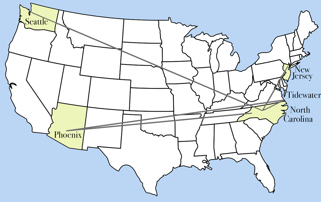
I have lived in four quarters of the continental United States. Born in New Jersey; left for college in North Carolina; moved to Seattle; returned to tidewater Virginia; spent 25 years in the desert Southwest; retiring in the mountains of N.C. In that time, I came across the fact of regional cultural differences.
Over my seven decades, though, I have seen those differences thin out. The Southern accent I heard in 1966 can still be found, but not so thickly, nor so prevalent as the one greeting me when I went to North Carolina for college.
Moving to the South when I was 17 years old was a shock. It was a completely different culture. In fact, the first thing I saw arriving at Guilford College was a huge homemade sign hanging from my dorm that read, “FORGET? HELL!” The Civil War was something in history books for Yankee me; in the South, it was in the soil.
The first time I was blindsided by these cultural differences was when my family took a summer vacation trip to Washington D.C., and on the way, in Maryland, we stopped for lunch and when I ordered a hamburger, my 8-year-old self was shocked, even horrified, that it came with mustard. At that age, you are pretty certain that what is familiar to you is what is normal, and that what is normal is “right.” Mustard did not belong on a burger. Ketchup did. Mustard was for hot dogs.

Food is a major part of the differences, especially the ones that persist. No one ate pickled herring in the South, and I couldn’t find a decent kaiser roll, to say nothing of pastrami or a real pizza. Cabbage was turned from a hot vegetable into slaw; instead of spinach, there were collards. (I later became quite fond of Eastern Carolina barbecue, hush puppies, and fried okra. In New Jersey, okra, if it ever appeared, was boiled and slimy. I now order me some “fried okree” whenever it’s on the menu.)

The regional differences have been sanded smooth over the years, as national chains supplant local businesses, nationally watched TV has blanded out the accents, and population migration has averaged out some of the distinctions. But vestiges of the flavor remains.
While the shock of easing from the North to the South is likely the greatest between regions, each section of the country had its idiosyncrasies.

When I moved to Seattle, there were salmon and giant geoduck clams (say, “gooey-duck.”) The design influence of Northwest coast Indians was common. And over the city, seen on a rare clear day, was a looming Mt. Rainier, somehow indistinguishable from the clouds. There were Rainier Beer commercials on TV. The populace was divided between Rainier drinkers and Olympia drinkers (locally known as “Oly.”)

In Arizona, there was great Mexican food everywhere, food so good that I miss it now, when eating at the ubiquitous Mexican restaurants outside the Southwest, the same way I miss New Jersey pizza. Yes, it’s still good, but nothing like the real thing. What they call “too hot” in North Carolina doesn’t even register on the tongue trained in Arizona. I’ve never had a green corn tamal anywhere that came close to those at the El Bravo restaurant in Phoenix.
But it isn’t just food that I wanted to write about. When I first came South in 1967, in my innocence, it hadn’t occurred to me that along with the change in accent from “dese” and “doze” to “y’all,” I would also confront a very different set of courtesies, different gender expectations, along with a different diet.
The most obvious was the awareness of race. In New Jersey, skin color wasn’t of much concern. By eighth grade, I habitually took the bus from the street in front of my house to Manhattan, where I spent many happy hours in the museums and book stores. The city was a vast mixture of ethnicities and the ferment was heady. It was also “normal.”

When I got to college, I learned that such a mixture was not considered normal. It wasn’t so much hatred, as it was a completely different attitude toward race. Everyone seemed aware of it at every turn. The east side of Lee Street in Greensboro, was where the “coloreds” lived. The barber near the college refused to cut the hair of our Sikh history professor because, he said, “We aren’t trained to cut black hair,” despite the fact that Dr. Suri, being Indian, was not black and the hair under his turban was notably straight. His skin was dusky.
There was obvious antagonism in some quarters. When the future NBA star M.L. Carr played on our college team (I went to a Quaker school, where segregation was not practiced, at least not overtly) and went to the local hash house with his white teammates, someone taking exception cut the brake line on their car while they were inside, causing them to crash on their way back to school.

And it could be downright ignorant and ugly. In 1968, a group of us liberal-minded Guilford students decided to visit a Ku Klux Klan rally in Liberty, N.C., to see what it was like. It was as vile as we had feared, including a cross burning and a main speaker who was also county sheriff. The smell of alcohol was in the air, along with the kerosene used to douse the rag-clad cross. I found out that they hated Catholics almost as much as they hated Jews and … you get the picture.
But most of the time, it wasn’t that obvious, just that the city bus through the upscale Starmount development left the main road to carry Black housemaids in the morning to their jobs, and in the afternoons back home. The infrastructure was designed to advantage racial expectations.
So, it wasn’t just race. Where I grew up in northern New Jersey, the populace was heavily Roman Catholic. My Boy Scout leader was Mr. Weinstein. Half the school spelled their surnames with a vowel at the end. I was best buds with Aurelio Orlandini. Some of my friends went to parochial school and had tales of nuns with rulers. Protestants went to church, Catholics went to Mass, and Jews went to temple. Just variant religious beliefs. Again, the mix seemed natural and we hardly gave a thought to it. At the Klan rally, however, even Methodists were suspect.
It was also manners. When I later married a Southern woman, she scolded me if I didn’t walk on the traffic side of the sidewalk. I wasn’t being discourteous; I had never been trained. Calling women “ma’am” or men “sir” wasn’t a thing, either. I had a lot to learn. I was used to, “Hey, Bud…”

In Jersey, the only marker of driving from one town to the next was a roadsign that said, “Entering Bogota” or “Entering New Milford.” The population was spread evenly over Bergen County, with no breaks between towns. When I got to the South, there was farmland or woods between settlements. How quaint, I thought.
People talked slower, moved slower, and while I grew up prioritizing efficiency, I learned that efficiency was considered merely rude below the Mason-Dixon line. Wait for that old lady on the corner to cross the street, even if the car can get out of her way much faster than she could get out of my way. I have lived in the South, now, longer than anywhere else, and I am now slower, too, and not just because I am old. Just yesterday, in the grocery store parking lot, I stopped the car to let a man pass in front of me. It hit me then that I have become acculturated. And it made me think again about all of this.
The plunge into the South as a callow youth may have been the biggest cultural shock, but each major move in my life gave me new surprises.

I knew snow in New Jersey, and humidity in North Carolina, but in Seattle, I learned that a constant drizzle wasn’t even considered rain. It took a downpour for anyone to consider an umbrella. Grey skies was the norm, and a sunny day was a news event. In Seattle, everything was on a hill, and a the Cascade Mountains walled the east and the Olympic Mountains dominated the west, across Puget Sound.
When my wife and I moved to Phoenix, where we lived for 25 years in the desert, instead of rain, we had endless days of sunlight, and eight months of unbearable heat. It may have been a dry heat, but when it hits 122 degrees, and the airport shuts down because of it, you aren’t much aware of the humidity index. And the so-called dry heat turns quite soggy in July and August with the advent of the monsoons, dragging humid air up from the Sea of Cortez. In most months, after taking a shower, you don’t need a towel; by the time you begin dressing, you are already dry. During monsoons, you stay indoors with AC or change shirts several times a day.

We thought nothing of driving an hour and a half to Tucson to watch an opera and then drive back when the curtain fell. Distance was felt differently from when I grew up, and the trip from Teaneck to Cliffside Park, where my grandparents lived, seemed expeditionary, although it was probably more like 7 miles. But then, I was a little kid back then and the world seemed immense to my novice brain.

I came to love the desert, although I never warmed up to Phoenix, which I used to call “Cleveland in the Desert.” Phoenix offers little charm, but lots of traffic. Still, on weekends we could drive out of the city to beautiful desert, mountains, and canyons. I got to travel almost everywhere in the state, writing for my newspaper. I wrote hundreds of travel stories.
But, I was, for the bulk of my career, an art critic. I grew up going to the Museum of Modern Art in New York, the Guggenheim, the Met, the Whitney. The city was attuned to international art. Other regions tended to feature regional myths and tastes, so, in the South, there were lots of paintings of tobacco barns and farmhouses. In Seattle, ravens and killer whales in the style of Northwest Coast Indians. Phoenix was awash in cactus and cowboy art. Of course, when I have traveled elsewhere in the U.S., those regional themes show up, too.

But after decades of increasing cultural uniformity, I see the country breaking up again, region from region. Not only red states from blue states, but rural from urban, Anglo from Hispanic. Not just the former Confederacy rebuilding the Lost Cause mythology, aiming its ire at the formerly industrial North, which spends very little time thinking about them. The working-class Northerners deriding the college-educated expertise. Everyone eyeing everyone else with suspicion.
I have come to think of the United States as comprising seven distinct regions, each with its own internal differences (i.e. barbecue vs. gumbo), but increasingly tribal allegiances. There’s the Northeast; the South; the Midwest north; the Plains states; Texas (yes, Texas is its own self-regarding region); the Southwest; and the Pacific states.

(My map has state lines as the borders of regionalism, but in reality, northern Virginia perhaps belongs now with the Northeast, and perhaps western Pennsylvania aligns better with the Midwest. My map is only a broad suggestion.)
Each has its distinct culture and folkways. Each, like me when I was eight years old, believing its own way is normal, and therefore right. Perhaps this alternating increase and watering down of cultural self-alienation is just a normal pattern of history, like the longterm shift leftward and the retrenchment shift rightward, and then back again, the breathing rhythm of culture, but the current re-stamping of regional passports seems to be making us increasingly insular. Although I’ve always enjoyed the flavor of regional difference, the regions I grew up with were largely unconcerned with other regions. The new regionalism seems to believe the others are somehow out to get them. I worry.