Archive

Tag Archives: travel

ny title

A cityscape is also a timescape.ny schist

And a visit to New York City is time travel. Roll the tape forward and back, and see the time-lapse version of the city, from the hard antediluvian schist that crops up in Central Park to the latest high-rise office complex.

We tend to think of America as a place that eats up its past, tearing down the old and erecting the new with no regard for history. And New York certainly has an energy that feeds on tomorrow.

But it is surprising how much of the past is still there, just left alone, standing in a multi-era crowd, with a brownstone wedged between a modern glass tower and a Beaux Arts library.

I suppose all of us who love the city have our defining frames in the time-lapse film. There is the fedora-topped bustle of New York in the 1940s, the World’s Fair gleam fighting the decay of the 1960s, the rhinestone Trumpification of the 1990s.

The city you remember best depends on how old you are and which version you first came to love.

But all of the versions are still there.

I first knew the city in the 1950s, and my memories are of Con Ed steam erupting from the streets in winter, diesel fumes filling the Port Authority Bus Terminal at 42nd Street like color fills a Titian, the squeal of the AA train (now the C train) as it fought the big curve between 168th and 175th streets. When I was a boy, we ice-skated at Rockefeller Center and window-shopped at Macy’s.ny in the subway

When I go back now, the subway still squeals, and the fumes are still the glorious aroma of the city, the garlic in its stew.

My city is still there, a little buried maybe, its face turned away.

That is not to say there aren’t chunks missing: Penn Station is gone; the Horn & Hardart Automat is gone; the current Madison Square Garden is a generic shadow of the old one; the Coliseum has been replaced by the gaudy Time Warner Center. Others, such as the Edward Durrell Stone Gallery of Modern Art, at Columbus Circle, have been given a new set of clothes.

Even Yankee Stadium has been torn down — Yankee Stadium, which I expected to last as long as the Roman Colosseum. (No such longing for Shea Stadium.)ny hudson river

Although some of the carcasses still exist along the Hudson River, the great ocean-liner piers are dusty, sagging, hollow or demolished.

And these don’t include the most obvious loss.

When I flew cross-country in 2005, the plane passed over Manhattan, and, from 30,000 feet, the missing place of the World Trade Center looked like nothing so much as the empty socket of a pulled tooth.

Yet, much of what I knew of New York when I grew up is still there.ny camilles

Four decades ago, I stopped at a coffeehouse just outside Columbia University. It was when coffeehouses, not Starbucks, were the natural accoutrements of student life. You had to step down from the sidewalk to the below-grade tables. Someone was playing folk songs on guitar. It was called Cafe Ole. Two years ago, I accidentally found the same spot when I stopped for breakfast. It’s now Camille’s, but the uneven brick floor was still there, and the steps. Forty years squeezed together like an accordion.

You didn’t have to be born there: New York has a historical presence for most of us. We saw it in the movies and newsreels, in gallery photographs and paintings.

The New York of the mind comes from seeing King Kong, Breakfast at Tiffany’s and The French Connection.

Not to mention the best evocation of the city ever transmuted to celluloid: Woody Allen’s Manhattan, that cinematic mash note:ny dusk

“He adored New York City. He idolized it all out of proportion — er, no, make that: He romanticized it all out of proportion. Yes. To him, no matter what the season was, this was still a town that existed in black and white and pulsated to the great tunes of George Gershwin.”

That New York of the mind is largely black and white. Or shades of gray. Even the snow in winter is gray. Like statuary, New York expresses form more than color.

Times Square sits in the mind like the black and white of Alfred Eisenstaedt, who photographed the famous V-J Day kiss there in 1945. The Staten Island Ferry does, too, and the crowds of people you pass on Sixth Avenue. (It will always be Sixth Avenue.)ny pizza

Enough people fill a block there, as lunch hour begins, to populate a ballpark, but most of them might as well be alone in the wilderness that Manhattan once was. People avoid colliding but never seem to make an effort to miss each other. There’s a subliminal awareness of the crowd, but you can see in their eyes that they aren’t primarily aware of the here and now: They are thinking of the meetings they are required to attend today or whether their husband has remembered to buy the potato salad for dinner tonight. Pairs or trios walk along talking, but they are leaves floating together downstream in a current.

In his tiny 1949 book, Here Is New York, E.B. White wrote, “New York blends the gift of privacy with the excitement of participation; and better than most dense communities, it succeeds in insulating the individual (if he wants it, and almost everybody wants and needs it) against all enormous and violent and wonderful events that are taking place every minute.”NY McDonalds

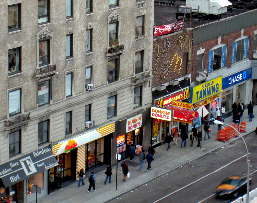
Stop at a storefront McDonald’s on a rainy November day and see the hordes lined up, warm against the cold outside, rubbing their hands as 40 people wait in ill-defined lines to be served. It’s noisy, yet quiet: The heat is steamy, the floor is worn. The bustle is enough to keep your ears electrified, but there is not much language to be heard outside the giving of food orders. The din is a roar of accelerating buses on the street, car horns, subways below the sidewalk grates and the incoherent susurrus of private conversation at tables.ny the met

It’s surprising how well people get on in New York, given the wide variety of types, ethnicities, politics and interests. The city makes room for all of them. Or, more precisely, the city takes equal lack of notice of all, so there is a kind of equality built in, an equality of negligibility.

It hasn’t always been that way. In the 1960s, the city seemed to be coming apart at the seams. The tourism slogan was “New York Is a Summer Festival,” but everyone in the city remembers it as “New York Is a Summer Fistfight.”

But now, allowing for the fact that you have 8 million people squeezed onto 300 square miles of land, the city is notably amicable: It has the lowest crime rate of the 25 largest U.S. cities, according to FBI statistics.ny grocery boxes

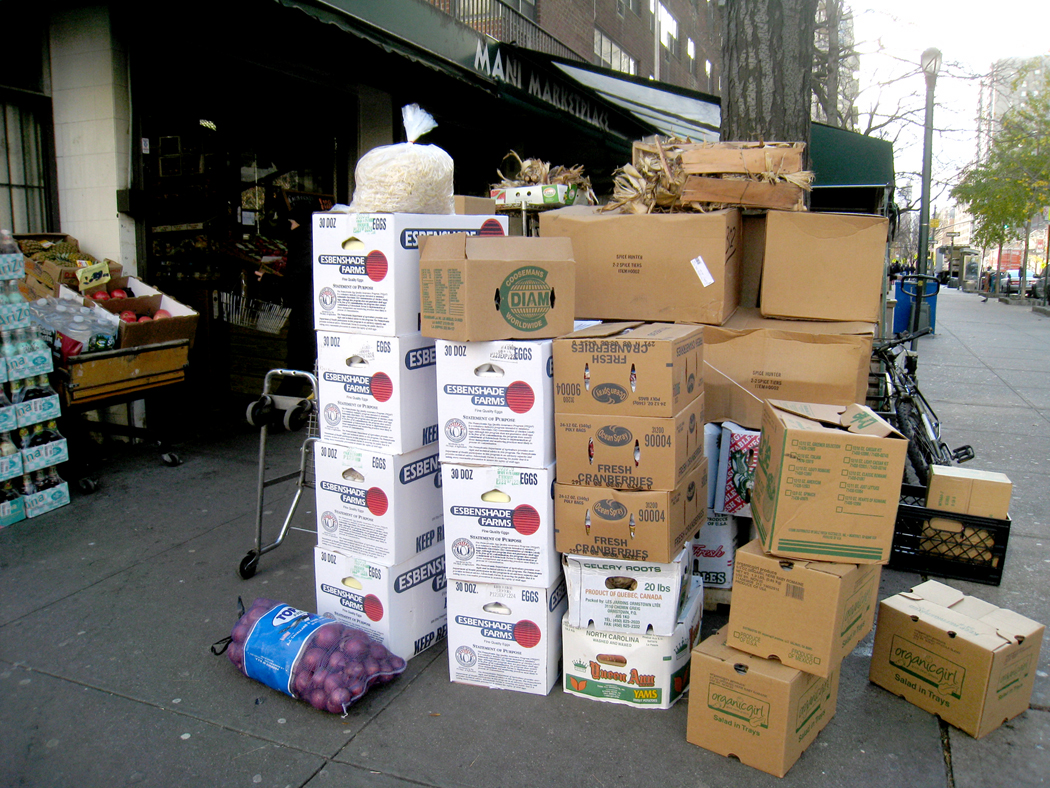
It is a city of diversity, and one that enjoys that about itself.

The last time I left the city, the hotel concierge phoned for a cab to take me to the airport. The cabbie was a large, bearded man with a black suit and an Eastern Europe accent; he drove a shiny black limo. Two blocks from the hotel, he pulled over. Another cab pulled over in front of us.

“If you please, my brother take you rest of way,” he said in a thick Boris Badenov voice. We emptied my bags into a second black limo.

The “brother,” who spoke with a Spanish, not Russian accent, explained as we drove that only one car in their fleet of cabs was authorized to pick up customers at the hotel, and so the first cab spent his day going from hotel to hotel, picking up customers and then redistributing them like a kindergarten teacher handing out cookies.

You come to expect such things in the city. It has always been this way.ny water tanks

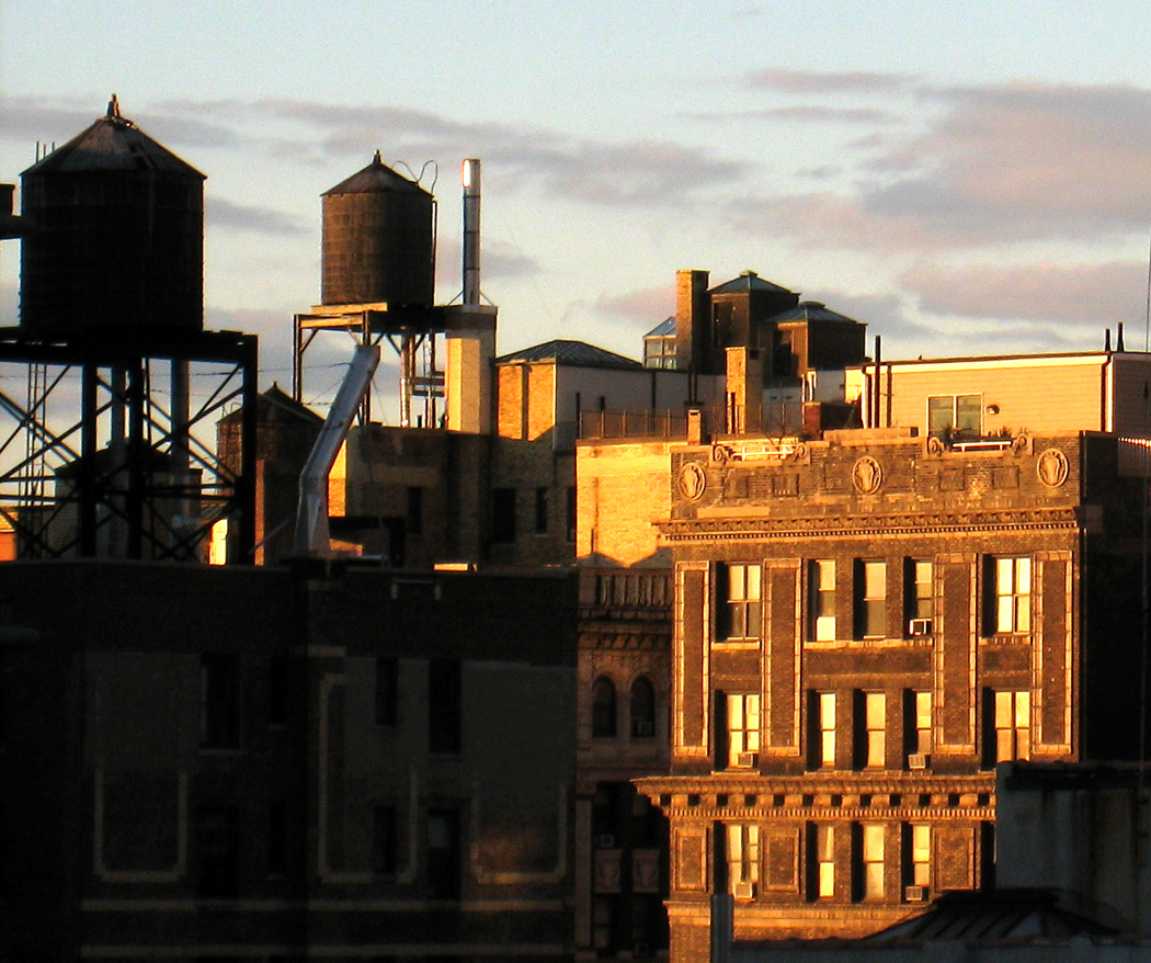
What single image can catch the essential persistence of New York? The subways, the cabbies, Mott Street? For me, it is the wooden water tanks on the roofs of high rises. One would think they would have been replaced by something modern, something in stainless steel, perhaps. But they haven’t: All over the city, roofs are defined by their wood-slat water tanks, sitting on the tops of buildings like the acroteria on Greek temples.

A tourist will never run out of things to catch his attention, or his dollar. But the Statue of Liberty, the Guggenheim and The Lion King are not the images that boil up in memory for me. It is the water tanks.ny alleyway

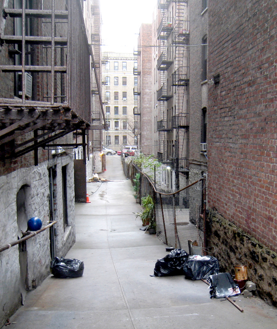
My essential New York is built of alleys between apartments on the upper West Side, their trash cans waiting to be emptied.ny 172nd st elevated station

It is the elevated train station at 125th Street, looking like some obsolete, alien spacecraft landed on stilts in the gully called Manhattan Valley.ny gwb

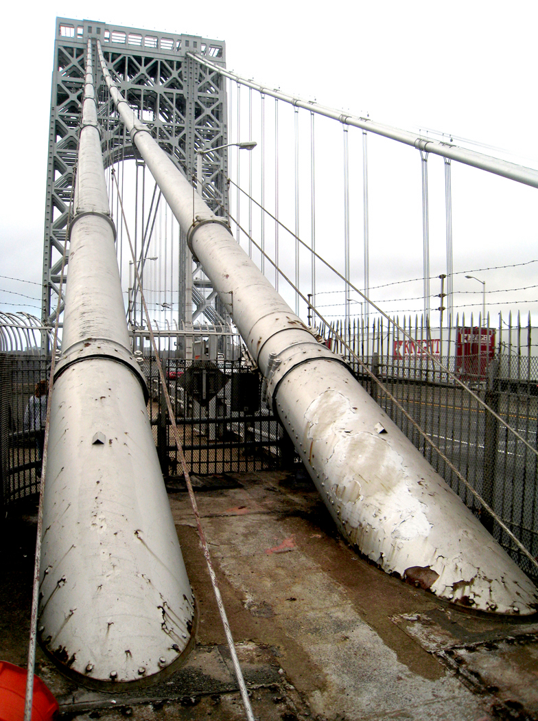
It is the George Washington Bridge, which my grandfather worked on as an engineer in the 1930s.

There is no better way to enter the city than to walk across the GWB. You get the sense of crossing some large space that defines the difference between the comfortable world you know and the beehive world of the city. The bridge is a behemoth, covered in a putty of silver paint, with leopard spots of rust. The noise of the traffic as it passes blots out awareness; it is a constant ear-splitting surf.

But you arrive at 178th Street, and the neighborhoods begin. It is important to recognize that New York isn’t a single city; it is hundreds of individual communities, each with their life-support drugstores, groceries, shoe stores, churches and pizzerias. The city may not be as medievally immobile as it used to be, when most New Yorkers rarely left their two- or three-block turf except to go to work, but those neighborhoods are still the hearts of local patriotisms, each an axis mundi.ny apartment building

The two-story 1920s frame houses that line the streets of Queens, the brownstones of Brooklyn, the awning-beaked apartments of 59th Street in Manhattan — each neighborhood has its flavor, its architecture, its private history.

I look at my life and I know that although I am a grayhair 6 decades old, the 10-year-old kid who watched the Macy’s Thanksgiving Day Parade is still there somewhere, and so is the college graduate who came back to the city, and the married man who vacationed there, and now the senex who encompasses them all. And just as my whole life is a single long memory — a single speck of meaning — the city is the same: Everything that ever happened there is still there.

oregon ice copy

I had forgotten how beautiful ice is.

But as I drove over the eastern side of the Cascade Mountains in Oregon, I saw the flat, silver surface of motionless lakes that caught the light from the sky.

And as I drove late last year past frozen creeks, I saw the shelf of white crusted a few inches above the water, caught on the reeds.

Above me at the top of the mountains, the snow scumbled across the near peaks looking like powdered sugar on a stony doughnut.

There’s a lot to be said for ice.

The only problem is that the ice is also on the road. And as I drive east into the low morning sun, it is glowing white on the blacktop, and I cannot tell what is ice from what is melted water until I am on top of it and can distinguish the wet hiss under the tires from the thudding bumps of crusted ice. It makes the trip from Bend to Silver Lake a trial of nerves.

I can remember when snow and ice hit in New Jersey, where I grew up. The snow was the color of ash and piled up on roadsides, filled with cinders and soot. Cars clanked by on tire chains, and others spun their wheels on the hill outside the house.

Ice was never a welcome event in New Jersey.

But after I lived for 10 years in the Western desert, I discovered that I missed the ice, not so much on roads, but in lakes and streams. I missed the rime on the grass early in the morning and the squeak of white powder under my boot soles.

So, as I pass near Fort Rock, coming out of Fremont National Forest, I slow to avoid the slick spots on the road, but I also slow to enjoy the concentric rings of increasing whiteness on the pond I pass that mark the nightly shrink of water. It is all solid now.

The ripples on its surface are motionless. A few slivers of straw from the bordering reeds blow across its top without getting wet. The ice is like a scab formed over the water to protect the pond and its fish and weeds from the killing cold of the air above.

In larger lakes, like Summer Lake and Goose Lake, there is a darker circle in the center, of still unfrozen water, and it shivers in the cold, breaking up the reflection of the mountains in wavelets that run across the water blown by wind. A front is coming in from the northwest. The high clouds filter a hazy, frigid sun. The forefront of the clouds is broken into stripes; it looks like fish bones.

Where the sun catches the snow patches on the slopes, it gleams with a brightness that seems of a different order of reality from the rest of the scene: almost like the psychedelic landscapes screaming by in 2001: A Space Odyssey.

And in the castellated crest of the Warner Mountains, as I enter California again, there is a bright coating of orange lichen that plays against the blue shadows in the snow so that the rocks sing out like a chorus: Kyrie Eleison.

Perhaps it is the cold, which makes the air seem as solid as crystal. Perhaps it is the sun, which even at noon comes in from such a low angle that it drowns all the landscape in the orange light of dusk. Perhaps it is the deep lapis of the sky at this altitude, which reflects off the ice of Goose Lake.

Or perhaps it is the contrast of the teeth-chattering cold against the steam that rises from the thick grasses in the meadows south of Lakeview, where thermal water boils from the ground and makes a network of streams in the valley floor.

But I had forgotten how beautiful ice is.

Pawnee Buttes 6

Space and time.

As you stand in the grassy expanse of the Great Plains, you are forced to confront them, Einstein’s two-faced god, the Janus of existence.

Time and space.

You stand at the stony edge of a low bluff and look out at a sea of grass and the cloud shadows racing over the buttes in Colorado’s Pawnee National Grassland, wetting them and drying them with shade and sun.

You feel yourself alone in the circle of the horizon — dead center in the universe of your own perception — and know, in a way you never do in the city, that you are alive on a planet. Pawnee road to horizon

Pawnee National Grassland is about 90 miles northeast of Denver. Within a 30- by 60-mile area just south of the Colorado-Wyoming state line, the Pawnee National Grassland encompasses old short-grass prairie and reclaimed farmland. The area is crossed mainly by unpaved roads, and the birds peel off from the side of the road as you drive by like the wake of a motorboat.

Sunflowers yellow the barbed wire on the shoulders of the roadway. Hordes of sunflowers, bobbing in the wind that is always exhaling. Pawnee sunflowers

It is easiest to get to the National Grassland from Denver. Usually, when we think of Denver, we think of the Rocky Mountains that loom above the city, but that is only if you face west. If you face east, Denver is the gateway to the Great Plains — the vast fifth of the United States that houses less than 3 percent of its people. Pawnee phone pole

A deeper beauty

The mountains are beautiful, but in a conventional way: Everyone can recognize their looks. But the Great Plains have a deeper beauty, and only those who spend time in this space can be gifted with seeing it.

As Walt Whitman wrote, “I am not so sure but the prairies and plains, while less stunning at first sight, last longer, fill the esthetic sense fuller, precede all the rest and make North America’s characteristic landscape. Even the prairie’s simplest statistics are sublime.” Pawnee fencepost

This region of northeastern Colorado was the subject of James Michener’s 1974 book, Centennial, and the history of the place was fictionalized in his tale.

But the real story is hardly less compelling. The prehistoric seas gave up the sea bottoms to become the middle of the continent. Dinosaurs, and later the great Cenozoic beasts, inhabited the area. Then there were Indians and buffaloes. Pronghorn, the fastest land animals in the western hemisphere

Finally, the buffalo hunter, the railroad, the cattle industry, the dry farmer, the droughts, the financial busts, the Dust Bowl, the emigrations and the land remaining like the butt end of a used cigarette.

You can feel all that history in the grass under your boot sole. windmill and sun vertical

By the mid-1930s, this portion of Weld County dropped to a tenth of its pre-Dust Bowl population.

That’s when the federal government and its Work Projects Administration tried to stabilize the economy, and the government began buying up plots of land. In 1938, responsibility for administering the land fell to the Soil Conservation Service.

In 1960, the Pawnee National Grassland was created. It is divided into two sections, each roughly square, just north of Colorado 14.

‘Rattlesnake Buttes’

The town of Briggsdale sits to the south of the road in the western sector. The towns of Buckingham and Raymer do the same in the eastern sector. They hardly qualify as towns: more like a collection of farm buildings, a few houses and maybe a grange hall.

The western sector contains the only campground, the Crow Valley Recreation Area, which sits in a depression of cottonwoods along Crow Creek. Crow Valley campgroungs

The eastern sector features the Pawnee Buttes, two erosional remnants that Michener calls “Rattlesnake Buttes” in Centennial.

“They were extraordinary, these two sentinels of the plains. Visible for miles in each direction, they guarded a bleak and silent empire,” he wrote. Pawnee Buttes 1

They tower about 350 feet over the plains at an altitude of 5,375 feet.

Getting to them requires a commitment. You have to drive on dirt roads about 15 miles, switching roads several times. It would be easy to get lost without a map. Get a map — available at a ranger station near Briggsdale.

You will pass Keota, a Dust Bowl ghost town, on the way. In its heyday, just after World War I, there were 140 people living there. Now, there are a few holdouts in the few remaining buildings. grasslands oil rig

Oil was found in the area in 1924, but that didn’t save the town. Even now, there are some oil pumps in the grasslands.

Between cattle grazing and mineral rights, the grasslands more than pay for themselves: 25 percent of oil and gas revenues are returned to Weld County for roads and schools. A similar percentage comes from grazing rights.

Wildlife treasured

But mostly the treasure to be found is in the wildlife: 301 species of birds; 400 species of plants. There are deer and pronghorns, prairie dogs, rattlesnakes.

The grasslands are not for the tourist, but for the traveler. There are no attractions in the flatness except the flatness itself. Lark Bunting

But for those who feel the atavistic call of the savanna, the veldt, the steppes, the pampas, this reminder of the tawny places in Africa that humankind came from, the grasslands speak volumes.

Grasslands, which cover 40 percent of the Earth’s surface, are home to almost 1 billion people.

Too often overlooked by tourists, who just want to get through the expanse as quickly as possible, the grassy middle of the country is, instead, what they should be looking for. Pawnee Buttes 5

Here you stand in a field of grasses that billow in the wind, with the same horizon you gaze at sea, and the same sky, and you recognize, more than in other landscapes, that each point in the endlessness is its very center.

It is the source of our national identity. It is the West we think of as our coming of age. It is the cradle of our greatest authors, the heart of our economy: the “amber waves of grain” and the “fruited plain.” Sunflower 2

And a sense of the bigness of the planet.

Time and space.

The author, Anders Vehus and old uncle Thorvald, 1966

The author, Anders Vehus and old uncle Thorvald, 1966

Old Thorvald was 87 and his jowled face was bristly with white whiskers. And like many elderly Norwegians, he was dressed in a loose-fitting black pinstriped suit with a four-button vest and starched white shirt, even though the two of us were out under the July sun with pitchforks, loading hay into the wagon.

In the southern tip of Norway, just north of Kristiansand, I was staying on a small chicken farm with a family distantly related to my own. Thorvald’s daughter, Marie, was married to Anders, who had raised money to buy his farm by working as a wood-floor layer in America. Their daughter, Ruth, was my age, and she made the rounds each afternoon, delivering eggs in their old beat-up Opel pickup truck. We ate eggs at most meals.

Thorvald smoked his pipe while leaning on the pitchfork and talked about his coming marriage, his fourth. He said he didn’t like the bachelor life and this new widow he had met was a good cook. His watery eyes brightened at the thought of food. He also said he didn’t like the weather, it was bad for haying.

It was the middle of July. Rains came every day at about 4 p.m. and left a rainbow over the rocky prominence at the edge of the property — Norway is all rock. That evening we ate fresh ham with its fat baked crisp around it — and eggs. We drank a warm, steamy ale that Anders had brewed in the kitchen. You might better have called it a ”malt cider.”

And in the evening that never seems to get dark, Anders played the fiddle and Thorvald strummed the mandolin.

Since they are Norwegian, they played hymns.

I mention all this because it is the little details that flesh out the recollection of travel: From travel years ago, I often cannot recall the major events, but I can taste, smell and hear the sensuous bits of which they are constituted.

The next morning, we drove to the little fishing town of Sogne, a tiny stone harbor ringed with immaculate red clapboard houses with white trim or white clapboard houses with dark green trim. There we boarded a bobbing fishing boat and headed out into the edges of the Skagerrak, the deep, cold rock-filled channel that separates Norway from Denmark.

Kristiansand, Norway, 1966

Kristiansand, Norway, 1966

The old boat putt-putted out into the iron-colored swell under a gunmetal sky toward a gray granite island with a single neatly painted wooden cabin on top.

In the arthritic wind, we hung a fishing line over the transom and dragged it behind us. The 25-foot boat rocked in the waves, scattering sea spray over us as its bow splashed up and down, slapping the water.

Ruth caught a 5-pound sea bass and wrapped it up in paper to bring home to her cat. Anders caught a bucketful of salmon, and I caught a chill in the salt spray.

Later that afternoon in the cabin on the rocky island, we cooked the pink-fleshed, sweet-fleshed salmon and ate them with potatoes and cucumber salad while we warmed ourselves in front of a wood fire and tried to dry out our sweaters in front of the hearth.

And when we came back to shore that evening, the sky still bright at 11 p.m., it snowed on us as we drove back to the farm.

It was the 29th day of July and we had snow. It was only a little flurry, but it was wet, clumping gobs of snow that stuck to the windshield.

Such little things, snow in July, are indelible.

We got back to the farmhouse, made the cat very happy and finally slept with the comforting, resinous smell of a wood fire in the kitchen stove.

Walpi

Walpi

The best Christmas I ever had was the Christmas of four gifts.

It happened on the Hopi Reservation a few years ago, when my wife and I left Phoenix because we just couldn’t take another holiday season under the palm trees.

Like many who lived in the desert, Carole and I grew up elsewhere, where Christmas meant freezing weather and the possibility of snow. Santa rides a sleigh, after all. But in Phoenix, Santa wears sunglasses. It just doesn’t seem right.

Not that we thought we’d find a traditional Christmas among the Hopi. Their traditions are rather different. But we thought we could at least escape the TV beer ads littered with reindeer and find something new outside the city where the backyard Christmas barbecue passes for holiday cheer.

Maybe we couldn’t have our old traditions, but we could start new ones.

If the traffic and commotion of the city get on your nerves, no better tonic exists than a visit to the three great mesas of yellow-gray sandstone that rise like gigantic library lions from the vast plains of the Colorado Plateau. Atop them the Hopi have built most of their villages, all from the stone of the hills. crow mother

From the mesa-top the view is biblical: You can see for what seems forever. The San Francisco Peaks sit on the horizon, some 75 miles to the southwest, yet they seem so close you feel you can walk to them.

On that Christmas Day, the temperature was about 29 degrees and the sun was low and cold, poking through an intermittent overcast. We stopped at the base of First Mesa to get gas at the little store in Polacca. We also bought a few gifts — some coffee and sugar — to bring to the women on the mesa-top who give tours of the village.

When we got back in the car, we discovered the woman behind the counter had quietly dropped candy and fruit into the poke with our purchases.

That was the first gift.

WALKING INTO HISTORY

The highlight of a visit to the three villages atop First Mesa is a tour of Walpi. The Hopi have lived in the community on the prow of the mesa for at least 1,000 years and some of the stone homes seem to be almost that old.

You park your car in the middle village, Sichomovi, and find a tour guide in Ponsi Hall, the community center. From there, you walk out across the narrow stone causeway to Walpi. Our guide was a woman we had met on several previous visits to the area. She is a warm, generous woman who was free with her answers to our many questions. I will not embarrass her by printing her name. walpi homes

She showed us the ancient masonry, the village layout, the meaning of the kivas and their spindly ladders that protrude from the ground. She told us of the kachinas, of blue cornmeal and of pahoes , or prayer sticks, whose feathers danced in the breeze on the edge of the mesa.

She also told us of her life in San Diego and how after years away from the mesa, she felt drawn back to it. pot carrier

And she told us how, like many Hopi women of First Mesa, she makes pottery.

Unlike most, though, she doesn’t make bowls, but effigies of turtles.

”They are like the Hopi,” she said. ”They live a slow-paced life.”

At the highest point of Walpi we came to the home of her aunt, who is one of the better-known Hopi potters. The old woman and Carole hit it off perfectly. They seemed to speak the same language.

They talked for quite a while. At one point, Carole asked if she knew where we might buy some of the blue cornmeal we had seen all over the reservation, and the woman reached a brown paper bag down from a high shelf and gave it to Carole, with instructions for cooking Hu zru’ su ki , or fried blue-corn polenta.

And when we bought one of her bowls, she smiled and whispered something in Carole’s ear and sprinkled some corn pollen into the pot.

That was the second gift.

OFF THE USUAL TOUR

Then, on our swing around the north side of the mesa top, our guide stopped in front of one small, square building and invited us in. It was her home, and inside, her daughter was putting the final touches of frosting on a batch of Christmas cookies. Hopi pot 2

The small room, with its stone floor covered with small rugs, was a toasty 75 degrees, with a fire going in the woodstove and condensation beading on the icy window glass. The family was bustling around, with Uncle in the back room attaching some down to the end of a ”lightning stick” and two boys helping the daughter with the cookies the way youngsters always help — by eating them.

A narrow shelf ran around the top of the room, about a foot below the ceiling, holding a collection of kachina dolls, lightning sticks, a toy bow and arrow and pottery.

Our guide explained what they were and handed out cookies. They were angels, and they were the best Christmas cookies I’ve ever eaten.

That was the third gift.

So, it was Christmas Day in the gracious, generous Hopi home, spending the afternoon with the family of a woman we now consider a friend.

When we stepped back out into the cold to leave, snow was falling all over Hopiland.

And that was the fourth gift: the wonderful warmth of Christmas snow, dropping gently in large flakes, catching on our hair and coats.

So, I say on leaving the mesas in my best attempt at Hopi: Quo-Quai – Thank you.hopi snow

Conclusion: In which the mountains dip into the sea

St. Georges de Malbaie Gaspe

St. Georges de Malbaie Gaspe

The Gaspe Peninsula in southern Quebec sticks out beneath the mouth of the St. Lawrence Seaway like a pouting lower lip.

It juts into the Gulf of St. Lawrence, protected from the open Atlantic by Nova Scotia and Newfoundland. There it sits, home to cod fisherman and farmers and an increasing number of vacationers. gaspesie 5

The peninsula’s interior is wild and mountainous — the last hurrah for the Appalachian chain — but its perimeter is bucolic, with small, quiet villages, each with a church steeple at its center.

Between Matane, where the peninsula begins, and Cape Gaspe, where it ends 200 miles later, there are only two roads that cross the interior.

Chic-Choc mountains

Chic-Choc mountains

From north to south, the roads leave the St. Lawrence, climb the Notre Dame and Shickshock mountains (aka Chic-Choc, in the bilingual nation) and wander down the deep river valleys lined with pine, fir and birch, only to come out on the prairie-lined towns along the Baie des Chaleurs.

The spine of the Appalachians runs the length of the Gaspe and it finally dives under the salt water at Forillon National Park, only to churn up the water beyond land’s end in a series of offshore shoals before sinking down into the sea bottom.

That last flowering of the ancient mountain chain is a splendid one, as the rock hangs over the water in a scalloped series of cliffs, each with a small semicircle of beach under it. The beach is made up, though, not of sand, but of small, smooth lozenges of stone that hiss and rattle as the breakers foam through them.

Cap Bon Ami, Forillon National Park

Cap Bon Ami, Forillon National Park

Nor does the shore slope smoothly into the water. All along the water’s edge, there are upended strata of rock that make for good clambering. At Cap Bon Ami — named for an old sea captain who spelled his own name Bonamy, and not for the scouring powder — the park road ends and you begin to hike.

A short way downhill from the parking lot, there is an observation deck and a set of several hundred stairs down to the beach. From that point, you can see the whitish cliffs spreading out in both directions. Cormorants and sea gulls swoop around you. Behind you rises Mont St. Alban, the last high peak of the Appalachians, which isn’t even 1,000 feet above the sea.

And in front of you, the sea itself spreads out like a gleaming satin tablecloth, flat and rippling with the sheen of daylight.

This is the sea that Jacques Cartier saw in 1534 when he made his first voyage to the New World. The French explorer discovered the native peoples of the area and kidnapped two of them to take back to show off to the king. On his second voyage, Cartier did not stop at Gaspe. Perhaps he knew his welcome no longer would be warm.

Gaspesie

Gaspesie

The few hardy French pioneers who took to living in the ”Gaspesie,” as the area is called by Francophones, found their towns burned down in the first half of the 18th century, when the English attempted a takeover of the whole New World. The Acadians, as the local French were known, were arrested, deported or forgotten.

In the following years, wars in Europe and North America sent migrants to Gaspe. Among them were American Loyalists fleeing the American Revolution, Irish fleeing potato famine, and merchants and fishermen from the islands of Guernsey and Jersey.

They settled in a patchwork across the peninsula, leaving towns along the coast as ethnic enclaves. That is why, in this corner of the French-chauvinist province of Quebec, you find towns named New Carlisle, Chandler and Newport, where English is the predominant language.

Mont Louis

Mont Louis

The interaction of languages produced a few oddities: What originally had been ”Hunger Point” in French, or Pointe a la Faim, was translated by the English as Point Fame, which later was retranslated into French as the current Pointe a la Renommee.

What was once ”Grande Grave” — named for the type of pebble beach called grave in French — was pronounced ”Grand Grave” in English, like a burial plot. This then later was spelled in French as Grand Greve, to match the sound of the English.

Most who lived in the region became fishermen. In the 19th century, large fishing corporations set up and ran ”company towns” that abused their workers in the same manner as mine owners in West Virginia. The families always owed money to the company store. There was no money; debts were paid in dried codfish, which the companies shipped out and resold at good profit.

Those who were lucky enough to avoid the codfish treadmill turned to subsistence farming. A few became whalers.

Peggy's Cove

Peggy’s Cove

Such a life continued unchanged until the 1920s, when roads were built, a railroad came through, and mail-order catalogs appeared. Electricity showed up after World War II, and the area, once as remote as anything in North America, began joining the 20th century.

Today, the southern and northern rims of the peninsula are very different.

Along the southern shore the towns collect around river mouths, surrounded by prairies of long grass blowing in the almost-constant wind. The land is flat, but you can look inland to the mountains.

The north shore, though, is right up against the hills, which break off into the water in bright bluffs and craggy cliffs. The one road that manages to squirrel from town to town is constantly climbing steep slopes and dropping down to the town in the next hollow.

And although the southern shore is ethnically varied, the north is almost entirely French.

There are two towns of note: Perce and Gaspe, both at the sea-end of the peninsula.

Perce

Perce

Perce is a tiny resort town parked near Perce Rock, an offshore seastack with a hole eroded through it like a giant stony donut. The town is the closest thing the Gaspe has to a tourist trap and the road through town will slow you down in summer with traffic stopping for souvenir shops and fancy restaurants.

There are also boat trips available to the large Ile de Bonaventure, sitting just offshore and one of the great bird-watching spots in the world.

Gaspe, on the other hand, is a working town and capital of the region. It is not particularly scenic, with its banks and gas stations, but it sits near the head of Gaspe Bay, the small inlet that separates the Forillon Park from the rest of the peninsula. It is at Gaspe that Cartier first landed. A museum commemorates the event.

Forillon Nationa Park

Forillon Nationa Park

And it is at Gaspe that we met the woman who runs the bookstore called the Librairie Alpha on the town’s hillside among the narrow, gray streets. She lamented the passing of the old days, and more, the old winters.

”It snows quite a lot in Gaspe,” she said in heavily accented English. ”But it doesn’t snow like it used to 20 years ago.

”I don’t know what has happened, but it isn’t so deep as it was in my childhood.”

In the winter, the bay ices over. It freezes ”as far out as the horizon,” she said. It stays frozen from December to April and people go out on the ice and fish.

”But they aren’t really there for fish,” she said. ”They bring beer and have parties on the ice.

”It freezes down two meters.”

In the winter, an icebreaker sails up into town as far as the bridge, breaking up the ice, but in a week, it is solid again, she told us.

But it doesn’t snow like it used to.

”I remember my father telling us about the really deep snows and how the snow would be so deep that everyone in the village would slide down their own rooftops into the snow.”

She said she remembered doing that when she was a child, but except once, the snow doesn’t pile up to the eaves anymore.

”Two years ago, it snowed so much, I took my children up to the roof to slide down. They may never have that chance again.”


L’ENVOI

 house montage

Gaspe is the ”roof of the Appalachians.” It is the final glory of the mountain range that begins in Alabama and rises like a spine through the East.

It is also a place of roofs. The old houses with their clapboard siding and double-insulated windows sport shingles of many bright colors. There are some that are royal blue, others Kelly green. If there are no shingles, but a tin roof, it is painted. I saw one that was the color of lilacs. Orange and red are also popular. house 5

But it isn’t only the roofs. The houses themselves are often quite garish. One two-story house we passed in Grande Vallee was green on the bottom and pink on the top, with corner accents of opposing hues. house 1

There was a green barn in Perce that was the color of mint. Its owner must have had a little left over, because he painted only one face of his house, sitting next to the barn, with the same breath-mint shade. The other three sides of the house were a peeling white. house 8

There were yellow houses, purple houses, pink houses and orange ones. The shades of green were staggering, sometimes two shades on the same building. house 10

Not all houses were oddly colored; the majority remained white and their roofs remained black or gray. Yet enough houses were tarted up to prove that it is a folkway on the Gaspe. house 2

It is true, however, that the majority of garish houses were on the south shore of the peninsula. Once we hit the northern shore, the strange colors nearly disappeared. Only once or twice in each village would you find a tin roof painted sky blue or vermilion.

Part 5: In which we consider living in Maine

front door

Maine is poor and that makes it rich.

Compare it with suburban Massachusetts and you see the difference. In the hills around Boston, the old homes have added jalousie windows — large panes of plate glass — and behind them you can see a collection of things bought in antiques shops. Out front is a Volvo or a Beemer.

But in backwoods Maine, the same antiques have gathered dust in the old farmhouse since they were new. Out front is a rusted Chevrolet or a Ford pickup. Barn

The New England homes, with their thin clapboards, are thickly painted and repainted their chalky white, and the paint nevertheless peels back on the window trim, showing gray, weathered wood underneath. The foundations are wavy with age and the lines of clapboard match them, looking like uneven topographic lines of a map. Screen doors have holes; barn doors sag on their hinges. But it is the sagging of use, not of neglect. In Rumford Point, for instance, many homes proudly tell the date they were built. You see ”1762” on one door, ”1780” on another. On one small building, you see ”1964,” which is a joke. Lubec hillside

Along the Androscoggin River are tall-steepled churches left over from the middle of the past century, still with their signs out front: Services held 10:30 a.m. Sunday. House side

One of the characteristics you notice is that the farmhouses are connected to the barns by a covered series of adjacent outbuildings. The winters are so severe that no one wants to go outside to tend the livestock, so you pass from the kitchen to the garage to the toolshed to the barn, all in toasty comfort. Well, as toasty as you can be when the siding boards are as loose as lattice and don’t always come down to the dirt, leaving an ankle-high draft. Yellow house

There are scrollwork on the eaves, wide fans over the door transoms, white fences along the sidewalks and, even in midsummer, storm windows. For even in July, on a wet, rainy day, it can be a raw, humid 70 degrees and it gets into your joints, so you feel arthritic. Or perhaps they are needed for protection against mosquitoes as big as hailstones that gather in swarms in cool, muggy air. Maine Schoodic door

But the countryside is poor, or if not poor — because that brings to mind inner-city malnourishment and anomie — certainly not well-off. As in much of southern Appalachia, the poverty is misleading. The people own their homes, grow their own food, know their own land. There is a Yankee self-sufficiency that grows with the spartan winters, lack of amenities and isolation.

NEXT: The Appalachians enter Canada

Part 4: In which we enter the landscape of the mind

Sorrento dock

Each of the United States has its own flavor, its own existence as myth. It is the sense one has, if one does not live in that state, but imagines what it would be like to visit.

One imagines what Arizona must be like, with its cowboys and cactus, but the reality of Phoenix — “Cleveland in the Desert” — negates that myth. That is the nature of myth.

Some states have bigger personae. California, for instance, which existed as myth both for “Forty-Niners” and for Okies. Montana offers big skies and clean air. Oregon had its trail and Mississippi has its Yoknapatawpha County.

Texas claims for itself the largest myth, although it is hard to warrant such big ideas if you have actually been to Midland or Odessa. Texas is only big in hectares. Otherwise, it is the state of large hats as substitutes for small manhood.

Each state has its mythic presence, although it is hard to make the case for Delaware as anything but the “gateway to New Jersey,” and the Garden State gains any resonance it has only from Tony Soprano and Bruce Springsteen.

But one state led all the rest historically in this landscape of the mind, as a special place in the American imagination, a place you dream about when you think your daily life is too mundane.

Lubec

Lubec

Historically, the state that has had the longest claim on the American spirit is Maine, with its deep woods and rocky coast, its taciturn, independent people and its echoing loons. Maine is the original great escape, the place to go to return to nature and feel what it is like canoeing across a backwoods lake with a mist rising from the water.

Maine is the place Henry David Thoreau went when his Walden Pond seemed too citified. Maine is the place that dozens of American artists went to find some glimmer of inspiring wilderness.

It’s also the place the 19th-century robber barons went for summer vacations.

As America has expanded westward, Maine has lost some of its magic, but it is still a mythical place, drawing millions of visitors every year.

But there isn’t a single Maine. Regionally, there are at least four Maines.

The first is the southern coast, which first attracted a wealthy clientele a hundred years ago. This is where old money came for the summer. It is where former President George H.W. Bush had his place in Kennebunkport. It is also home to the new Yuppie tourism centers on Penobscot Bay, where you can always get a good brioche: Camden and Rockport. They are not much different, in their way, from Carmel, Calif., or Sedona, Ariz. — all trendy shops and new museums. You visit L.L. Bean in Freeport, and see a hundred other factory outlet stores.

Mooselookmeguntic Lake

Mooselookmeguntic Lake

Then, there is the mountainous Maine of the western part of the state with its thousand lakes, from Rangeley Lake to Mooselookmegunticook. This is the part of Maine famous for its out-of-place town names: Mexico, Norway, Paris. It is a place to go for fishing and camping or renting a cabin for a week.

The large northern part of the state is especially impressive. Vast tracts of woodland crisscrossed by narrow logging roads down which rumble the most frightening, earthshaking pulpwood trucks, piled high and tenuously with rattling bundles of spruce trunks. It is the north of Baxter State Park and Mount Katahdin. This is the Maine that Thoreau wrote about in his book, The Maine Woods. It is also the part of the state, on its eastern side, where they grow potatoes.Maine tree

But it is the fourth Maine that I love the most: the upper coast, from Mount Desert Island to the Canadian border.

This is Down East. It is the least touched by commercialism. It is still composed of blue-collar working towns where men go out to fish or pull lobsters from the rocky-bottomed sea. It is old wooden houses on granite foundations and cars rusted out from wet, salty winters.

Otter Cove, Acadia NP

Otter Cove, Acadia NP

It is called Down East because when 19th-century sailing packets traveled up the coast from Boston, they sailed downwind, with the prevailing breezes abaft. Back then, Maine was still part of Massachusetts. Maine owes its statehood to slavery: The Missouri Compromise of 1820 let the slave state Missouri enter the union, but separated Maine from Massachusetts and entered it as a state at the same time to keep a balance of free and slave states in Congress.

The coast of Maine is about 250 miles long, as the crow flies, but it must have been a very drunken crow that first flew the distance. With all the bays and headlands, the actual distance of that zig-zag coastline is closer to 3,000 miles. And that’s not counting the islands, thousands of them.

Mount Desert Island is the largest of them. It is properly pronounced Mount “Dessert,” as if it were filled with chocolate moose, but most people just call it MDI and be done with it. MDI is the home of Acadia National Park, one of the most beautiful in America.

Monument Cove, Acadia NP

Monument Cove, Acadia NP

It is also the home of Bar Harbor, one of the most congested towns. In the summer, Bar Harbor is a vacation nightmare, with no parking, crowded restaurants and no room at the inn.

Acadia National Park covers about half the island and includes Cadillac Mountain, the tallest mountain on the East Coast north of Rio de Janeiro. At 1,530 feet, it catches the first rays of sunlight to hit the U.S. each day.

A road to the top provides splendid views.

But it is the view of Cadillac Mountain, rather than the view from it that is best. And the best views are from the coast roads that continue farther down east.

The real Down East begins beyond MDI. From Ellsworth — which may look like one unending K mart and KFC — you drive east and north on U.S. 1 and you leave all the tourists and development behind.

Fox Lake

Fox Lake

The towns you pass are small and picturesque: Sullivan, Gouldsboro, Sorrento, Winter Harbor, Jonesport. You see tall church steeples and town squares with bronze statues of World War I soldiers.

This is Maine for the traveler rather than the tourist. You won’t find many fancy restaurants, and the motels are all low-dollar. Look instead for breakfast in the local lunch counter with the lobstermen. There are no “destination locations.” You have to be interested in the place for itself, and not for an amusement park.

If you are looking to get away from it all, Down East is the definition of the phrase.

Machias

Machias

There are mountains to be climbed, woods to be hiked, lakes to be canoed. There are heaths to be gleaned of their blueberries and birds to scout out and listen to.

Blueberry heath

Blueberry heath

If you hike in the woods behind Sullivan, off Taunton Bay, you will find the abandoned granite quarries that used to provide curbstones for the cities of the East Coast.

Climb 1,069-foot Schoodic Mountain for the panoramic view. Or if that is too high, try 397-foot Tucker Mountain. A walk through the birches and alders will bring you to a splendid view of Frenchman Bay and Cadillac Mountain.

Schoodic Point, Acadia NP

Schoodic Point, Acadia NP

From Gouldsboro, head south to Schoodic Point, which is part of Acadia, but without the crowds. The waves boom on the rocks and a cold ocean separates you from Cadillac in the west. If there is one perfect place to visit Down East, Schoodic Point is it.

Quoddy Head Lighthouse

Quoddy Head Lighthouse

Or take the narrow road south of Lubec and you will come to the West Quoddy Head lighthouse, the easternmost point in the U.S. Out on the horizon you will see Canada’s Grand Manan Island. It might as well be China.

Take a look at any map of the eastern bump of Maine and see how the web of roads thin out. Hancock and Washington counties are nearly unpaved. It is empty. It is beautiful. It is the real Maine.

NEXT: Maine redux

Part 3: In which a previous president gets some work done

plymouth notch

As in the rest of the country, the modern world of CVS pharmacies, Burger Kings and Pep Boys has superseded the old neighborhood stores and previous ways of life in New England. Vermont has pushed back more than other states, but life is modernizing there, too.

Silent Cal

Silent Cal

But if you want to find out what old country life was really like, the best place to get a hint is at the Calvin Coolidge State Historic Site in Plymouth Notch. There, you can see the house where the taciturn and much-maligned 30th president was born, and a second where he grew up. You also can see the giant woodshed needed to keep the house marginally above freezing in the winter; you can see the two-hole privy and the smelly kerosene lanterns.

For Calvin Coolidge grew up in old country Vermont. It was hard work, and there were no potpourris nestled in the corner with the perfumed smell of herbs and spices. The smell of the house must have been a little closer to horse manure, which was collected in the stable — attached to the house like a modern-day garage — and was shoveled through a trapdoor to a collection pit under the house. coolidge 14

His quilt didn’t have cute children printed on it. In fact, when he was 10 years old, Coolidge made a quilt for himself. It is a very good quilt, too. Old Cal was pretty good with his hands. In his house, there is a chest of drawers he made when he was a little older. He would have been a right good carpenter if he had chosen that line of work.

”After the winter work of laying in a supply of wood had been done,” Coolidge wrote in his autobiography, ”the farm year began about the first of April with the opening of the maple-sugar season. This was the most interesting of all the farm operations to me.”

In a good season, they processed as much as a ton of maple syrup. But that is not all. ”After that, the fences had to be repaired where they had been broken down by the snow, the cattle turned out to pasture, and the spring planting done. Then came sheep-shearing time, which was followed by getting in the hay, harvesting and threshing of the grain, cutting and husking the corn, digging the potatoes and picking the apples. Just before Thanksgiving, the poultry had to be dressed for market, and a little later, the fattened hogs were butchered and the meat salted down. Early in the winter, a beef creature was slaughtered.

Coolidge works the horses

Coolidge works the horses

”The work of the farm was done by the oxen, except running the mowing machine and horse rake. I early learned to drive oxen and used to plow with them alone when I was 12 years old. Of course, there was the constant care of the domestic animals, the milking of the cows and taking them to and from pasture, which was especially my responsibility.”

And all around the village of Plymouth Notch, maintained as a state park, you can see the results of that self-reliance, which is the hallmark of the mountain population. coolidge 6

You can see the dark room where Coolidge, then vice president, learned of Warren Harding’s death. Coolidge’s father, a notary public, swore his son in as president using the oath Calvin had typed out on the family typewriter.

Asked how he knew he could swear in his son, old Col. Coolidge said, ”I didn’t know I couldn’t.”

NEXT: Remembering Maine

Part 2: In which certain suggestions are made

Kancamagus Highway

Kancamagus Highway

One of the best ways to see the wild parts of New England is via the Kancamagus Highway, which runs between Lincoln and Conway, N.H. Along its 35 miles, you pass white-water rivers, towering granite and long views from the mountain passes.

The road, which was opened only in 1968, climbs from the Pemigewasset River to Kancamagus Pass, crossing the crest at 2,850 feet and following the Swift River down the other side.

Rocky Gorge on the Swift River

Rocky Gorge on the Swift River

Near the Bear Notch Road turnoff is the Passaconaway Historic Site, with a nature center and summer demonstrations by craft workers in period costume. In the Rocky Gorge Scenic Area are waterfalls, hiking paths and camping in the Covered Bridge Campground.

But it isn’t the only road worth taking. The road up Mount Washington is a thrill ride of declivities and chasms, bound together with the coil of roadway.

To be sure, there are three choices for getting up Mount Washington.

Appalachian Trail, Presidential Range

Appalachian Trail, Presidential Range

The first is to climb on foot; the Appalachian Trail winds up the rocky slopes, but it is probably too strenuous for most visitors.

Mt. Washington Auto Road, with cog railway tracks in foreground.

Mt. Washington Auto Road, with cog railway tracks in foreground.

The second choice is to drive up the Mount Washington Auto Road, opened in 1861. It is a harem-scarem eight-mile drive that averages 12 percent grades and snakes around hairpin turns, and when you get back down, you probably will buy the popular bumper sticker that reads ”I survived the Mt. Washington Auto Road.” cog railway

The easiest way up is the Mount Washington Cog Railway, which climbs the other side of the mountain from Crawford Notch. The 3 1/2-mile trip, which climbs grades up to 37 percent, takes a little longer, but is great fun.

Both road and rail have what may seem ”steep” admission prices.

The New England states are small, but each offers something for the traveler.

In Vermont, the countryside itself is reason to visit, and just about anywhere you go is scenic, though more gentle than New Hampshire. Popular tourist stops include Queechee Gorge, Woodstock and Weston, all of which are filled with places to separate the tourist from his money.

Ben and Jerry factory

Ben and Jerry factory

For some people, the most magnetic draw of the state will be Ben and Jerry’s Ice Cream Factory in Waterbury, with half-hour tours and samples. It is now the No. 1 tourist attraction in the state.

The Massachusetts portion of the Appalachians highlights Mount Greylock and the Berkshires. But there is also historic Stockbridge and its Norman Rockwell Museum — and, if you can find it, the former Alice’s Restaurant.

Arrowhead

Arrowhead

Author Herman Melville wrote several short stories about the Berkshire Mountains, and you can visit his home, Arrowhead, in Pittsfield, where his notorious “piazza” on the north side of his home, looks out on Mt. Greylock — “Charlemagne among his peers.”

And in Maine, Baxter State Park is a treasure. A few nights in a wood-heated cabin beside Daicey Pond, under the shadow of Mount Katahdin, will fix what ails you and set the universe right.

Reich Museum

Reich Museum

But if that doesn’t work, try the Wilhelm Reich Museum, in Rangely, which its tenant called his ”Orgone Energy Observatory.” In a nutshell, so to speak, Reich believed that you could use great sex to make it rain.

NEXT: Cool Calvin Coolidge